

-
Products -PCBA Manufacturing RF Connectors RF Cable Assemblys Embedded Antennas External Antennas Positioning Chips and Modules
RF Connectors

RF Cable Assemblys
Embedded Antennas
External Antennas
Positioning Chips and Modules


 Language


Language


Global Navigation Satellite System (GNSS) Real-Time Kinematic (RTK) technology has revolutionized precision positioning, enabling centimeter-level accuracy for a wide range of professional applications—from surveying and construction to agriculture and maritime operations. At the core of any high-performance GNSS RTK setup is the antenna, which captures satellite signals and transmits them to the RTK receiver for processing. For applications that operate in harsh, wet environments (e.g., outdoor construction sites, coastal surveys, agricultural fields during rainfall), a waterproof GNSS RTK external antenna system is not just a convenience but a necessity.
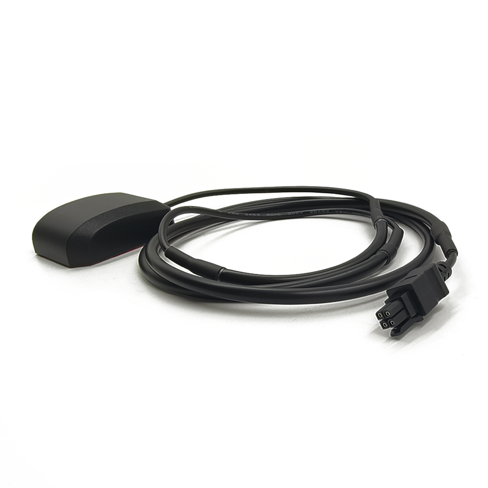
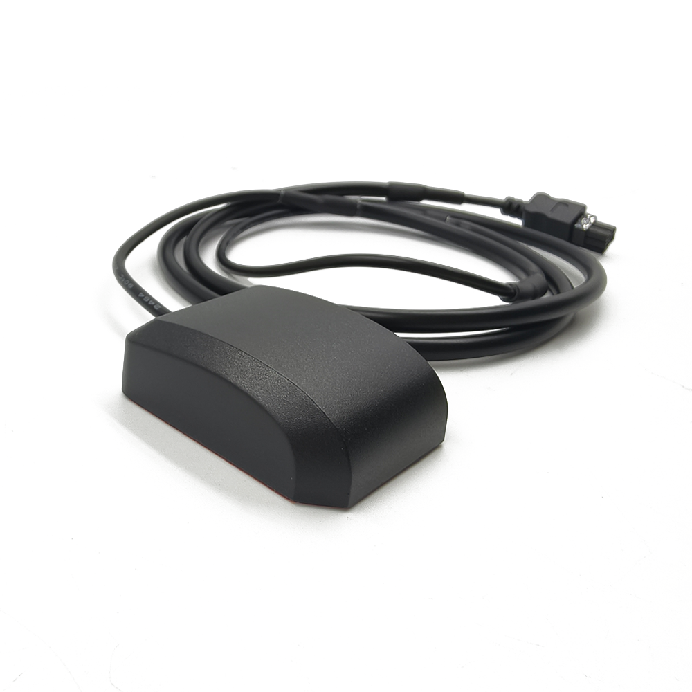
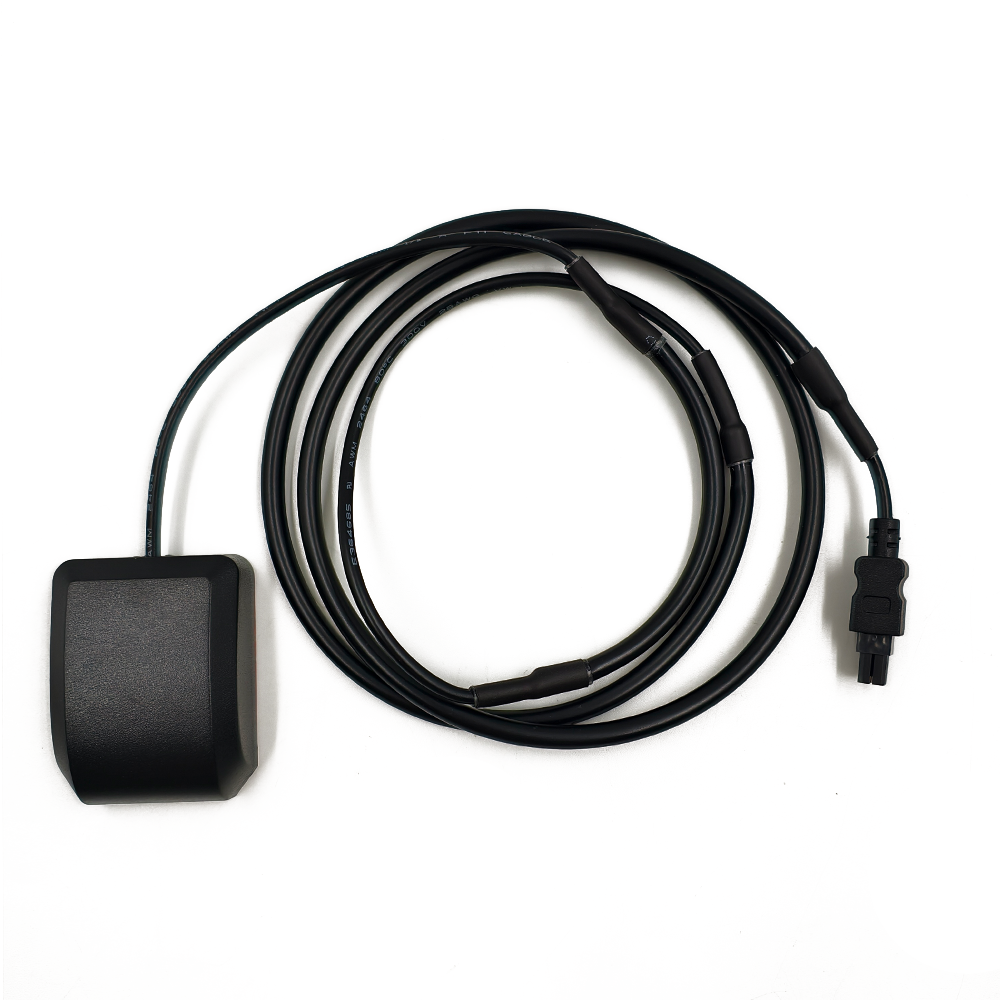
Unlike internal antennas (which are embedded within devices like smartphones or wearables) or non-waterproof external antennas, waterproof GNSS RTK external systems are designed to withstand prolonged exposure to water, moisture, dust, and extreme temperatures while maintaining uncompromised signal reception and RTK precision. The term “external” here is critical: these antennas are mounted outside the receiver (e.g., on a survey pole, vehicle roof, or maritime vessel) to avoid signal blockage from the receiver’s chassis or surrounding structures, ensuring maximum visibility to GNSS satellites (including GPS, Galileo, BeiDou, and GLONASS).
The primary goal of a waterproof GNSS RTK external antenna system is to deliver consistent, high-quality satellite signals to the RTK receiver, which uses them to calculate precise position data in real time. RTK technology relies on two components: a base station (fixed at a known location) and a rover (the mobile unit with the antenna). The base station transmits correction data to the rover, which combines this with its own satellite signal data to achieve centimeter-level accuracy. For this process to work in wet conditions, the rover’s antenna must remain functional even when exposed to rain, splashes, or temporary submersion—hence the need for robust waterproofing.
Key specifications define these systems: waterproof ratings (typically IP67, IP68, or IP69K, indicating resistance to dust and water ingress), operating temperature ranges (-40°C to 85°C for industrial-grade models), and multi-constellation/multi-band support (to capture signals from multiple satellites and frequency bands, e.g., L1, L2, L5, for improved accuracy and reliability). Additionally, these antennas are often designed with low noise figures (NF < 1.5 dB) to minimize signal interference, ensuring that even weak satellite signals are captured and processed effectively.
In recent years, the demand for waterproof GNSS RTK external antenna systems has grown rapidly, driven by the expansion of precision industries. For example, in smart agriculture, farmers use these antennas to guide autonomous tractors with centimeter-level precision, even during heavy rain; in maritime navigation, they enable precise positioning of ships and offshore platforms in rough seas. As industries continue to prioritize accuracy and reliability in harsh environments, these antenna systems have become indispensable tools for professional users.
The design and construction of waterproof GNSS RTK external antenna systems require a meticulous blend of precision engineering, durable materials, and robust waterproofing techniques. Unlike standard GNSS antennas, these systems must balance three critical priorities: uncompromised signal reception (for RTK’s centimeter-level accuracy), resistance to harsh environmental conditions (water, dust, temperature extremes), and mechanical stability (to withstand vibration or physical impact). This section breaks down the key design considerations, materials, and construction processes that define these high-performance systems.
Core Design Considerations for RTK Performance
At the heart of a waterproof GNSS RTK external antenna system is its ability to capture weak satellite signals with minimal noise—a requirement for RTK’s precision. To achieve this, the antenna’s radiating element is designed to support multiple GNSS constellations (GPS, Galileo, BeiDou, GLONASS) and frequency bands (L1, L2, L5). Multi-band support is particularly important: L2 and L5 bands offer better resistance to interference (e.g., from atmospheric disturbances or radio frequency noise) than L1, making them critical for maintaining accuracy in challenging environments.
The antenna’s radiation pattern is another key design factor. RTK applications require a hemispherical radiation pattern (covering the entire sky above the antenna), ensuring that signals from satellites in all azimuths and elevations are captured. This is achieved through the use of patch antenna designs (e.g., microstrip patches or array patches) or helical antennas, which provide wide coverage while maintaining compact dimensions. For example, a patch antenna array—consisting of multiple small radiating elements—can be tuned to capture signals from multiple bands, with each element optimized for a specific frequency.
Mechanical design also plays a role in performance. The antenna is typically mounted on a low-profile housing to reduce wind resistance (critical for applications like drone surveying or maritime navigation) and to minimize signal blockage. The housing is also designed to be compatible with standard mounting hardware (e.g., 5/8-inch threads for survey poles, magnetic mounts for vehicles), ensuring flexibility across use cases.
Waterproofing and Environmental Protection
Waterproofing is the defining feature of these systems, and it is achieved through a combination of sealed housings, gaskets, and potting materials. The most common waterproof rating for these antennas is IP68, which means they are dust-tight and can withstand submersion in water up to 1.5 meters for 30 minutes; industrial-grade models may have an IP69K rating, indicating resistance to high-pressure, high-temperature water jets (used for cleaning in harsh environments like construction sites).
The antenna’s housing is typically made from durable, non-conductive materials like polycarbonate or fiberglass-reinforced plastic (FRP). These materials are lightweight, resistant to UV radiation (to prevent degradation from sunlight), and have low dielectric constants (to minimize signal attenuation). The housing is sealed using rubber gaskets (e.g., silicone or EPDM) at all entry points—such as the cable connector or mounting holes—to prevent water ingress. For critical components (e.g., the low-noise amplifier, or LNA), potting compounds (e.g., epoxy resin) are used to encapsulate the electronics, creating a waterproof barrier that also protects against vibration and shock.
The antenna’s cable is another critical component for waterproofing. Most systems use a coaxial cable (e.g., RG-58 or RG-174) with a waterproof jacket (e.g., PVC or TPU) and a sealed connector (e.g., SMA, TNC, or N-type). The connector is often equipped with an O-ring seal to prevent water from entering the antenna housing through the cable entry point. Some high-end models also use armored cables to withstand physical damage (e.g., from being dragged across rough terrain in construction sites).
Materials for Durability and Signal Integrity
The choice of materials directly impacts the antenna’s performance and lifespan. The radiating element is typically made from high-conductivity metals like copper or silver, which ensure efficient signal capture. The element is etched onto a dielectric substrate (e.g., Rogers 4350 or FR-4), which has a low loss tangent (tanδ < 0.005) to minimize signal loss. For high-temperature applications, ceramic substrates may be used, as they offer better thermal stability than organic substrates.
The LNA— a critical component that amplifies weak satellite signals before they are sent to the RTK receiver— is designed with low-noise components (e.g., GaAs or SiGe transistors) to maintain a low noise figure (NF < 1.5 dB). The LNA is mounted inside the antenna housing, close to the radiating element, to reduce signal loss between the element and the amplifier. To protect the LNA from temperature extremes, the housing may include thermal management features (e.g., heat sinks or thermal pads) to dissipate heat, ensuring consistent performance even in high-temperature environments.
Manufacturing and Quality Control
The manufacturing process for waterproof GNSS RTK external antenna systems involves strict quality control to ensure reliability. After assembly, each antenna undergoes a series of tests: waterproofing tests (e.g., submersion in water for IP68 compliance), signal performance tests (measuring gain, noise figure, and impedance matching), and environmental tests (exposure to temperature cycles, vibration, and UV radiation). Antennas that fail any test are rejected, ensuring that only high-quality systems reach the market.
For example, a manufacturer may subject an antenna to a “temperature shock test,” cycling it between -40°C and 85°C to simulate extreme weather conditions, and then measure its signal performance to ensure no degradation. Similarly, a “vibration test” (following IEC standards) ensures that the antenna remains functional after exposure to the vibration levels experienced in vehicle or drone applications. These rigorous tests are critical for professional users, who rely on the antenna to perform consistently in mission-critical environments.
To understand how waterproof GNSS RTK external antenna systems deliver centimeter-level accuracy in wet environments, it is essential to break down their core working principles—from signal capture and waterproof signal transmission to integration with the RTK receiver and correction data processing. Unlike standard GNSS antennas, these systems must maintain signal integrity even when exposed to water, dust, or temperature extremes, while enabling the real-time correction process that defines RTK technology. This section explains the key mechanisms that drive their performance.
Signal Capture and Multi-Band/Multi-Constellation Support
The primary function of a waterproof GNSS RTK external antenna is to capture electromagnetic (EM) signals from multiple GNSS satellites and frequency bands. RTK technology requires signals from at least four satellites to calculate a precise 3D position (latitude, longitude, elevation), but for centimeter-level accuracy, the antenna must capture signals from as many satellites and bands as possible. This is why these antennas are designed to support multi-constellation (GPS, Galileo, BeiDou, GLONASS) and multi-band (L1, L2, L5) reception.
Each frequency band serves a specific purpose: L1 (1575.42 MHz for GPS) is the most widely used band but is more susceptible to interference; L2 (1227.60 MHz for GPS) offers better resistance to atmospheric errors (e.g., ionospheric delays); L5 (1176.45 MHz for GPS/Galileo) is a newer band with even higher accuracy and interference resistance. The antenna’s radiating element—typically a patch array or helical design— is tuned to resonate at these frequencies, ensuring that signals from each band are captured efficiently. For example, a multi-band patch antenna may have separate radiating elements for L1, L2, and L5, each optimized for their respective frequencies, allowing the antenna to capture signals from all bands simultaneously.
The antenna’s hemispherical radiation pattern is critical here: it ensures that signals from satellites in all parts of the sky (from low elevations near the horizon to high elevations overhead) are captured. This is particularly important in urban or forested areas, where satellite visibility may be limited, but even more so in wet environments—where rain or fog can weaken signals, making it essential to capture as many signals as possible.
Low-Noise Amplification and Signal Conditioning
Once the antenna captures satellite signals, they are passed to a low-noise amplifier (LNA) — a critical component mounted inside the waterproof housing. GNSS signals are extremely weak when they reach the Earth’s surface (typically -130 dBm to -160 dBm), so they must be amplified before they are sent to the RTK receiver. However, amplification can introduce noise, which degrades signal quality. To avoid this, the LNA is designed with a low noise figure (NF < 1.5 dB), meaning it amplifies the signal while adding minimal noise.
The LNA is positioned close to the radiating element to minimize signal loss during transmission from the element to the amplifier. This is especially important for weak signals: even a small amount of loss (e.g., 1 dB) can reduce the receiver’s ability to process the signal, leading to lower accuracy. After amplification, the signal is filtered to remove unwanted interference (e.g., from nearby radio transmitters or industrial equipment) using band-pass filters that allow only GNSS frequencies to pass through.
Waterproof Signal Transmission to the RTK Receiver
The amplified and filtered signal is then transmitted from the antenna to the RTK receiver via a waterproof coaxial cable. The cable’s design is critical for maintaining signal integrity in wet conditions: it has a conductive core (to carry the signal), a dielectric insulator (to prevent signal leakage), a shielding layer (to block interference), and a waterproof outer jacket (to prevent water ingress). The connector at the antenna end (e.g., SMA or TNC) is sealed with an O-ring, ensuring that water cannot enter the antenna housing through the cable entry point.
The RTK receiver — whether mounted on a survey pole, vehicle, or drone — processes the signal to extract raw satellite data (e.g., time of flight, satellite position). But RTK accuracy requires more than just raw data: it needs correction data from a base station.
RTK Correction Data Integration
The RTK process relies on two units: a base station (fixed at a known location) and a rover (the mobile unit with the waterproof antenna). The base station uses its own high-precision antenna to capture satellite signals and calculate its position. Since the base station’s true location is known, it can determine the error in the satellite signals (e.g., due to atmospheric delays or satellite clock errors) and generate correction data.
This correction data is transmitted to the rover via a wireless link (e.g., radio, cellular, or satellite). The rover’s receiver combines the correction data with the raw satellite data from its waterproof antenna to correct for errors, resulting in centimeter-level accuracy. For example, if the base station detects a 1-meter error in the satellite signals, it sends this correction to the rover, which adjusts its position calculation accordingly.
Performance in Wet Environments
The waterproof design of the antenna ensures that this entire process remains functional even when exposed to water. The IP-rated housing, sealed connectors, and potted electronics prevent water from damaging the LNA or radiating element, while the durable materials resist corrosion from saltwater (critical for maritime applications). Additionally, the antenna’s low-noise design ensures that even in wet conditions—where rain or fog may weaken signals—the LNA amplifies the remaining signals sufficiently for the receiver to process them, maintaining RTK accuracy.
For example, in a construction site during heavy rain, the waterproof antenna continues to capture satellite signals, amplify them with minimal noise, and transmit them to the rover. The rover combines these signals with correction data from the base station, allowing construction workers to lay concrete or install structures with centimeter-level precision—even in the rain. Without a waterproof antenna, water ingress would damage the electronics, disrupting the signal and making accurate positioning impossible.
Waterproof GNSS RTK external antenna systems offer a unique set of advantages that make them indispensable for precision applications in harsh, wet environments. However, they also face inherent challenges—from cost and size to environmental limitations—that users and manufacturers must address. Understanding these pros and cons is critical for selecting the right system for specific use cases and for driving future improvements. This section explores both sides of the spectrum, highlighting how these systems deliver value while navigating key obstacles.
Advantages
Uncompromised Precision in Wet Conditions
The most significant advantage of waterproof GNSS RTK external antenna systems is their ability to maintain centimeter-level accuracy even when exposed to water, rain, or moisture. For industries like surveying, construction, and maritime navigation, where work cannot stop for inclement weather, this is a game-changer. For example, a land surveyor using a waterproof RTK antenna can continue mapping a site during heavy rain, ensuring that project timelines are met without sacrificing accuracy. In maritime applications, these antennas enable precise positioning of ships and offshore wind turbines in rough seas, where splashes or temporary submersion are common. Without waterproofing, standard antennas would fail, leading to costly delays or inaccurate data.
Multi-Constellation/Multi-Band Support for Reliability
Unlike basic GNSS antennas, waterproof RTK external systems are designed to support multiple satellite constellations (GPS, Galileo, BeiDou, GLONASS) and frequency bands (L1, L2, L5). This multi-constellation/band support significantly improves reliability, especially in challenging environments. For example, in urban canyons or forested areas, where satellite visibility is limited, the antenna can capture signals from multiple constellations, ensuring that the RTK receiver has enough data to calculate a precise position. Multi-band support (e.g., L2 and L5) also reduces the impact of interference and atmospheric errors, further enhancing accuracy. For professional users, this reliability is critical: a single loss of signal can lead to rework (e.g., in construction) or safety risks (e.g., in maritime navigation).
Durable Design for Harsh Environments
Waterproof GNSS RTK external antenna systems are built to withstand more than just water—they are designed for industrial-grade durability. Most models have IP67, IP68, or IP69K ratings, meaning they are dust-tight and resistant to temperature extremes (-40°C to 85°C), vibration, and physical impact. For example, in agriculture, an antenna mounted on a tractor can withstand vibration from the vehicle’s movement and exposure to dust and mud, while still delivering accurate signals for autonomous plowing. In mining, these antennas can operate in dusty, high-temperature environments, enabling precise positioning of mining equipment. This durability reduces maintenance costs and downtime, as the antenna does not need to be replaced frequently due to environmental damage.
Flexible Mounting for Versatile Applications
These antennas are designed with versatile mounting options, making them suitable for a wide range of use cases. Common mounts include 5/8-inch threads (for survey poles), magnetic mounts (for vehicles), and drone-compatible mounts (for aerial surveying). For example, a surveyor can mount the antenna on a pole for ground mapping, while a farmer can attach it to a tractor for precision seeding. This flexibility means that a single antenna can be used across multiple projects, reducing equipment costs for users. Additionally, the external mounting design ensures that the antenna has unobstructed visibility to the sky, unlike internal antennas which may be blocked by the receiver’s chassis.
Challenges
Higher Cost Compared to Standard Antennas
One of the most significant challenges of waterproof GNSS RTK external antenna systems is their higher cost. The robust waterproofing materials (e.g., IP68-rated housings, sealed connectors, potting compounds), multi-band/multi-constellation hardware, and low-noise amplifiers (LNAs) all add to the manufacturing cost. For example, a high-quality waterproof RTK antenna can cost 2–5 times more than a non-waterproof, single-band GNSS antenna. This cost barrier can be prohibitive for small businesses or individual users (e.g., independent surveyors) who may not have the budget for industrial-grade equipment. While the long-term durability of these systems can offset replacement costs, the initial investment remains a deterrent for many potential users.
Size and Weight Constraints
Waterproofing and multi-band support often result in larger, heavier antennas compared to standard models. For example, a compact waterproof RTK antenna may measure 10–15 cm in diameter and weigh 200–300 grams, while a non-waterproof single-band antenna could be half that size and weight. This can be problematic for applications where space and weight are critical, such as drone surveying or portable handheld devices. A heavier antenna mounted on a drone can reduce flight time (by increasing power consumption) or limit maneuverability, while a bulky antenna may be difficult to carry for field surveyors working long hours. Manufacturers are working to miniaturize components (e.g., smaller LNAs, thinner waterproof housings), but balancing size, weight, and performance remains a key challenge.
Signal Attenuation in Extreme Wet Conditions
While waterproofing protects the antenna’s electronics from water damage, extreme wet conditions (e.g., heavy rain, thick fog, or submersion) can still cause signal attenuation. Water droplets in the air absorb and scatter GNSS signals, reducing signal strength before it reaches the antenna. This is particularly problematic for RTK systems, which rely on weak signals to achieve centimeter-level accuracy. For example, in heavy rain, signal strength can drop by 5–10 dB, making it harder for the antenna to capture enough satellite signals for reliable positioning. While multi-band support helps mitigate this (e.g., L5 signals are less affected by rain than L1), it does not eliminate the issue entirely. In submersion scenarios (e.g., a maritime antenna temporarily underwater), signal loss is even more severe, as water is a far more effective signal absorber than air.
Maintenance and Repair Complexity
Waterproof GNSS RTK external antenna systems are designed for durability, but they are not immune to wear and tear—especially in harsh environments. Over time, waterproof seals (e.g., O-rings, gaskets) can degrade due to UV radiation, temperature cycles, or chemical exposure (e.g., saltwater in maritime applications), compromising waterproofing. Repairing these systems is often more complex and costly than repairing standard antennas. For example, replacing a damaged waterproof seal requires specialized tools and knowledge to ensure the antenna remains IP-rated after repair. In some cases, if the internal electronics (e.g., LNA) are damaged, the entire antenna may need to be replaced—since opening the waterproof housing to repair components can the seal and render the antenna non-waterproof. This increases maintenance costs and downtime for users who rely on the antenna for daily operations.
Compatibility with Legacy RTK Systems
Many industries (e.g., construction, surveying) have existing RTK systems that were designed for non-waterproof or single-band antennas. Integrating a new waterproof multi-band antenna with these legacy systems can be challenging due to compatibility issues. For example, older RTK receivers may not support newer frequency bands (e.g., L5) or may have different impedance requirements (e.g., 75 ohms instead of the standard 50 ohms for modern antennas). This means users may need to upgrade not just the antenna, but also the receiver—adding to the overall cost. Additionally, some legacy systems use proprietary communication protocols for correction data, which may not work seamlessly with newer waterproof antennas. Manufacturers are working to improve backward compatibility (e.g., producing antennas with switchable impedance, supporting older protocols), but this remains a barrier for users with established systems.
Waterproof GNSS RTK external antenna systems are deployed across a wide range of industries, where precision positioning in wet or harsh environments is critical. From guiding autonomous tractors in the rain to enabling safe maritime navigation, these systems have become essential tools for professional users. As technology advances, emerging trends are poised to expand their capabilities further—addressing current challenges and unlocking new use cases. This section explores the key applications of these systems today and the trends shaping their future.
Current Applications
Precision Agriculture
In agriculture, waterproof GNSS RTK external antenna systems are the backbone of precision farming techniques—enabling farmers to optimize crop yields while reducing resource waste. These antennas are mounted on autonomous tractors, harvesters, and drones, providing centimeter-level accuracy for tasks like seeding, fertilizing, and spraying—even in wet conditions (e.g., post-rainfall or early-morning dew). For example, a tractor equipped with a waterproof RTK antenna can plant seeds in straight rows with less than 2 cm of deviation, ensuring uniform crop growth and maximizing land use. In regions with frequent rainfall (e.g., the U.S. Midwest, Southeast Asia), these antennas allow farming operations to continue without interruption, avoiding delays that could reduce yields. Additionally, drones fitted with waterproof RTK antennas can conduct crop health surveys in the rain, capturing high-resolution images that help farmers identify pest infestations or nutrient deficiencies early.
Surveying and Geospatial Mapping
Land surveyors and geospatial professionals rely on waterproof GNSS RTK external antenna systems to collect accurate data in all weather conditions. Whether mapping a construction site during a downpour, surveying a coastal wetland at high tide, or measuring a mountainous region in fog, these antennas ensure that position data remains precise and reliable. For example, in coastal surveying—where antennas are often exposed to saltwater splashes—the IP68 or IP69K rating of these systems prevents corrosion and water damage, while multi-band support captures signals even when fog weakens L1 bands. Surveyors also use these antennas for applications like boundary mapping and topographic surveys, where accuracy is critical for legal or engineering purposes. Without waterproofing, a single rainstorm could damage the antenna and force the survey to be redone—costing time and money.
Maritime Navigation and Offshore Operations
The maritime industry is one of the largest users of waterproof GNSS RTK external antenna systems, where they enable precise positioning for ships, offshore platforms, and underwater vehicles. For commercial ships, these antennas are mounted on the bridge, providing centimeter-level accuracy for tasks like docking, collision avoidance, and navigating narrow waterways (e.g., canals or coastal channels)—even in rough seas with waves splashing over the deck. Offshore oil and gas platforms use RTK antennas to position drilling rigs and supply vessels, ensuring that operations are conducted safely and efficiently in saltwater environments. Underwater remotely operated vehicles (ROVs) also use these antennas (mounted on their surface controllers) to track their position relative to the seabed, enabling precise underwater inspections or repairs. The saltwater resistance of these systems is critical here: standard antennas would corrode quickly in saltwater, but waterproof RTK antennas use materials like marine-grade aluminum and corrosion-resistant coatings to withstand harsh maritime conditions.
Construction and Infrastructure Development
In construction, waterproof GNSS RTK external antenna systems are used to guide heavy machinery (e.g., excavators, bulldozers, concrete pavers) with precision—even in rainy or dusty conditions. For example, during the construction of a highway, an excavator equipped with a waterproof RTK antenna can dig trenches to exact depths and widths, ensuring that the road base meets engineering specifications. These antennas also play a role in high-rise construction, where they are mounted on cranes to track the position of building materials (e.g., steel beams) as they are lifted to upper floors. In wet weather, when construction schedules are often delayed, these antennas allow work to continue—reducing project timelines and costs. Additionally, these antennas are used for as-built surveys, where they capture the exact position of completed infrastructure (e.g., bridges, tunnels) for documentation and maintenance purposes.
Search and Rescue (SAR) Operations
Search and rescue teams rely on waterproof GNSS RTK external antenna systems to locate missing persons or vehicles in remote or harsh environments—including forests, mountains, and flood zones. These antennas are mounted on SAR vehicles, drones, and handheld receivers, providing precise positioning data even in heavy rain or snow. For example, in a flood scenario, a drone fitted with a waterproof RTK antenna can map the affected area, identifying safe routes for rescue teams and locating survivors stranded on rooftops. Handheld RTK receivers with waterproof antennas allow rescuers to navigate through flooded terrain with centimeter-level accuracy, avoiding hazards like submerged debris. The durability of these systems is critical here: SAR operations often involve rough handling and exposure to extreme weather, so the antenna must withstand impacts, water, and temperature extremes.
Future Trends
Miniaturization and Weight Reduction
One of the most promising trends in waterproof GNSS RTK external antenna systems is the miniaturization of components—enabling smaller, lighter antennas without sacrificing performance. Manufacturers are using advanced materials (e.g., thin-film ceramics for substrates, micro-LNAs) to reduce the size of the antenna’s radiating element and electronics. For example, a next-generation waterproof RTK antenna could measure just 5–8 cm in diameter and weigh less than 100 grams—making it ideal for drone surveying and portable devices. Miniaturization also reduces wind resistance, which is critical for drones (as it extends flight time) and maritime applications (where strong winds can damage larger antennas). Additionally, lighter antennas are easier for field workers to carry, improving usability in remote areas.
Integration with 5G and Satellite Communication
The integration of waterproof GNSS RTK external antenna systems with 5G and satellite communication networks is set to revolutionize precision positioning. 5G networks offer high-speed, low-latency data transmission, which is critical for RTK systems—especially in applications like autonomous driving or drone swarms, where correction data must be delivered in real time. For example, a 5G-enabled waterproof RTK antenna can receive correction data from a base station in milliseconds, ensuring that autonomous tractors or drones adjust their position instantly. Satellite communication integration will extend this capability to remote areas (e.g., deserts, oceans) where 5G coverage is unavailable. By combining GNSS RTK with satellite communication, these antennas can provide precise positioning anywhere on Earth—even in the most isolated environments.
AI-Powered Signal Optimization
Artificial intelligence (AI) and machine learning (ML) are being integrated into waterproof GNSS RTK external antenna systems to optimize signal reception in challenging conditions. AI algorithms can analyze real-time signal data (e.g., strength, noise levels, satellite visibility) and adjust the antenna’s parameters (e.g., radiation pattern, frequency band selection) to maximize performance. For example, in heavy rain, an AI-powered antenna can switch from L1 to L5 bands (which are less affected by rain) or adjust its radiation pattern to focus on satellites with stronger signals. ML algorithms can also learn from past performance data, predicting which parameters will work best in specific environments (e.g., fog, saltwater) and adapting automatically. This will reduce the need for manual adjustments by users and improve the antenna’s reliability in extreme conditions.
Eco-Friendly and Sustainable Designs
As industries prioritize sustainability, manufacturers are developing waterproof GNSS RTK external antenna systems with eco-friendly materials and designs. This includes using recycled plastics for housings, biodegradable potting compounds, and lead-free solders for electronics. Additionally, some manufacturers are designing antennas with modular components—allowing users to replace damaged parts (e.g., seals, cables) instead of replacing the entire antenna. This reduces electronic waste and extends the antenna’s lifespan. For example, a modular waterproof RTK antenna could have a replaceable O-ring seal, which can be swapped out when it degrades—instead of discarding the entire antenna. These sustainable designs not only benefit the environment but also reduce long-term costs for users.
Enhanced Submersion Resistance
While current waterproof GNSS RTK external antenna systems can withstand temporary submersion (e.g., IP68-rated antennas can be submerged up to 1.5 meters for 30 minutes), future systems will offer enhanced submersion resistance for underwater applications. This includes using pressure-resistant housings that can withstand depths of 10 meters or more, as well as materials that are immune to corrosion from saltwater or chemicals. These advanced underwater antennas will enable new applications, such as positioning underwater ROVs for deep-sea exploration or monitoring underwater infrastructure (e.g., pipelines, cables) with centimeter-level accuracy. Additionally, enhanced submersion resistance will benefit maritime applications, where antennas may be submerged for longer periods during storms or high tides.
Conclusion
Waterproof GNSS RTK external antenna systems represent a critical intersection of precision engineering and environmental resilience, enabling centimeter-level positioning in the harshest wet and harsh environments. Throughout this analysis, we have explored how these systems address the unique needs of industries ranging from agriculture to maritime navigation—delivering uncompromised accuracy even when exposed to rain, saltwater, dust, and temperature extremes. From their robust design and construction to their integration with RTK technology, these antennas have become indispensable tools for professional users who cannot afford downtime or inaccurate data.
The overview section established the core purpose of these systems: to bridge the gap between RTK’s precision requirements and the challenges of wet environments. The design and construction segment highlighted the meticulous choices—from IP-rated housings and low-noise amplifiers to multi-band radiating elements—that enable their performance. The working principles explained how these components collaborate to capture, amplify, and transmit signals, while integrating RTK correction data to achieve centimeter-level accuracy. The advantages and challenges section balanced the benefits of durability and reliability against the realities of cost, size, and signal attenuation. Finally, the applications and future trends section demonstrated their versatility across industries and outlined how emerging technologies like AI and miniaturization will expand their capabilities.
Key takeaways from this exploration include the critical role of waterproofing in maintaining RTK performance, the value of multi-constellation/multi-band support for reliability, and the potential of emerging trends to address current limitations (e.g., size, signal attenuation). For users, these systems are more than just antennas—they are enablers of efficiency, safety, and innovation. For example, a farmer using a waterproof RTK antenna can optimize crop yields by continuing operations in the rain, while a maritime navigator relies on these systems to avoid collisions in rough seas.
Looking ahead, the future of waterproof GNSS RTK external antenna systems is defined by progress: miniaturization will make them more versatile, AI will enhance their adaptability, and sustainability will reduce their environmental impact. These advancements will unlock new applications—from deep-sea positioning to autonomous drone swarms—while making precision positioning more accessible to small businesses and individual users.
In conclusion, waterproof GNSS RTK external antenna systems are a testament to how technology can adapt to the demands of the natural world. By combining precision with resilience, they empower industries to work smarter, safer, and more efficiently—regardless of the weather or environment. As these systems continue to evolve, they will remain at the forefront of precision positioning, driving innovation and progress in the industries that rely on them.

 86 0755 2819 9597
Lucy Yang | lucy.y@toxutech.com
Nicole Li | nicole@toxutech.com
Dotty Zhao | sales04@toxutech.com
Global Business Director / Sales Team / Global Operations


 En
En Cn
Cn Korean
 Home >


