

-
Products -PCBA Manufacturing RF Connectors RF Cable Assemblys Embedded Antennas External Antennas Positioning Chips and Modules
RF Connectors

RF Cable Assemblys
Embedded Antennas
External Antennas
Positioning Chips and Modules


 Language


Language


Multi-band Real-Time Kinematic (RTK) Global Navigation Satellite System (GNSS) modules represent a paradigm shift in drone navigation, enabling centimeter-level positioning accuracy in real time. Traditional GNSS receivers, such as those relying solely on GPS L1 signals, suffer from meter-level inaccuracies due to ionospheric delays, multipath errors, and satellite clock biases. RTK technology addresses these limitations by using differential corrections from a ground-based reference station, while multi-band receivers enhance robustness by processing signals across multiple frequencies (e.g., L1, L2, L5, E1, E5a, B1I, B2a) and constellations (GPS, GLONASS, Galileo, BeiDou, QZSS).
1.1 Introduction to Multi-Band RTK GNSS Technology
Multi-band Real-Time Kinematic (RTK) Global Navigation Satellite System (GNSS) modules represent a paradigm shift in drone navigation, enabling centimeter-level positioning accuracy in real time. Traditional GNSS receivers, such as those relying solely on GPS L1 signals, suffer from meter-level inaccuracies due to ionospheric delays, multipath errors, and satellite clock biases. RTK technology addresses these limitations by using differential corrections from a ground-based reference station, while multi-band receivers enhance robustness by processing signals across multiple frequencies (e.g., L1, L2, L5, E1, E5a, B1I, B2a) and constellations (GPS, GLONASS, Galileo, BeiDou, QZSS).
The integration of multi-band RTK GNSS modules into drones has revolutionized industries requiring high-precision positioning, including surveying, agriculture, construction, and infrastructure inspection. Unlike Post-Processed Kinematic (PPK) systems, which require offline data processing, RTK provides instantaneous corrections, enabling real-time decision-making and dynamic mission adjustments.
1.2 Market Dynamics and Growth Drivers
The global market for RTK GNSS-enabled drones is experiencing exponential growth, driven by:
Increasing demand for precision agriculture: Farmers leverage RTK drones for variable-rate application of fertilizers and pesticides, optimizing resource use and reducing environmental impact.
Urbanization and infrastructure development: Construction and mining companies use RTK drones for volumetric measurements, terrain modeling, and progress monitoring with sub-5 cm accuracy.
Regulatory push for safety and compliance: Aviation authorities mandate RTK for Beyond Visual Line of Sight (BVLOS) operations, ensuring safe navigation in congested airspace.
Technological advancements: Miniaturization of multi-band receivers, coupled with AI-driven error correction algorithms, has made RTK viable for small UAVs (under 250g).
According to MarketsandMarkets, the RTK GNSS drone market is projected to grow from
500millionin2025to
1.2 billion by 2030, at a CAGR of 15%. Key players include u-blox, CubePilot, Septentrio, Swift Navigation, and DJI, with products like the CubePilot Here4, u-blox ZED-F9P, and DJI D-RTK 2 dominating the high-precision segment.
1.3 Key Features of Multi-Band RTK GNSS Modules
Modern multi-band RTK modules for drones incorporate the following features:
Multi-Constellation Support: Tracking 100+ channels across GPS, GLONASS, Galileo, BeiDou, and QZSS ensures signal redundancy in obstructed environments.
Dual-Band or Tri-Band Processing: Simultaneous use of L1/L2 or L1/L5 frequencies mitigates ionospheric errors and accelerates ambiguity resolution.
High Update Rates: Positional data at 20 Hz or higher enables stable flight in dynamic conditions (e.g., wind gusts, rapid maneuvers).
Compact Form Factor: Modules like the Here4 (16×68mm, 60g) integrate GNSS, IMU, and barometer functions, minimizing payload impact.
Open-Source Compatibility: DroneCAN and MAVLink support facilitate integration with autopilots like ArduPilot and PX4, reducing development costs.
1.4 Challenges and Limitations
Despite their advantages, multi-band RTK GNSS modules face challenges:
High Cost: Premium modules (e.g., Here4) retail at
800–
1,200, limiting adoption in budget-conscious markets.
Base Station Dependency: RTK requires a nearby reference station or network correction service (e.g., NTRIP, u-blox PointPerfect), which may be unavailable in remote areas.
Signal Vulnerability: Heavy rain, dense foliage, or urban canyons can degrade signal quality, necessitating fallback to IMU-based dead reckoning.
Security Risks: Open RTCM protocols are susceptible to spoofing attacks, though encryption and authentication mechanisms are emerging.
2.1 Core Components of Multi-Band RTK GNSS Modules
A typical multi-band RTK GNSS module consists of:
2.1.1 GNSS Receiver Chipset
The chipset is the module’s brain, processing raw satellite signals and performing RTK calculations. Leading solutions include:
u-blox ZED-F9P: A dual-band (L1/L2) receiver supporting GPS, GLONASS, Galileo, and BeiDou with 184-channel tracking.
Septentrio AsteRx-m3 Pro: A tri-band (L1/L2/L5) receiver with advanced anti-jamming and spoofing detection.
STMicroelectronics Teseo-LIV3F: A low-power dual-band chipset optimized for battery-powered drones.
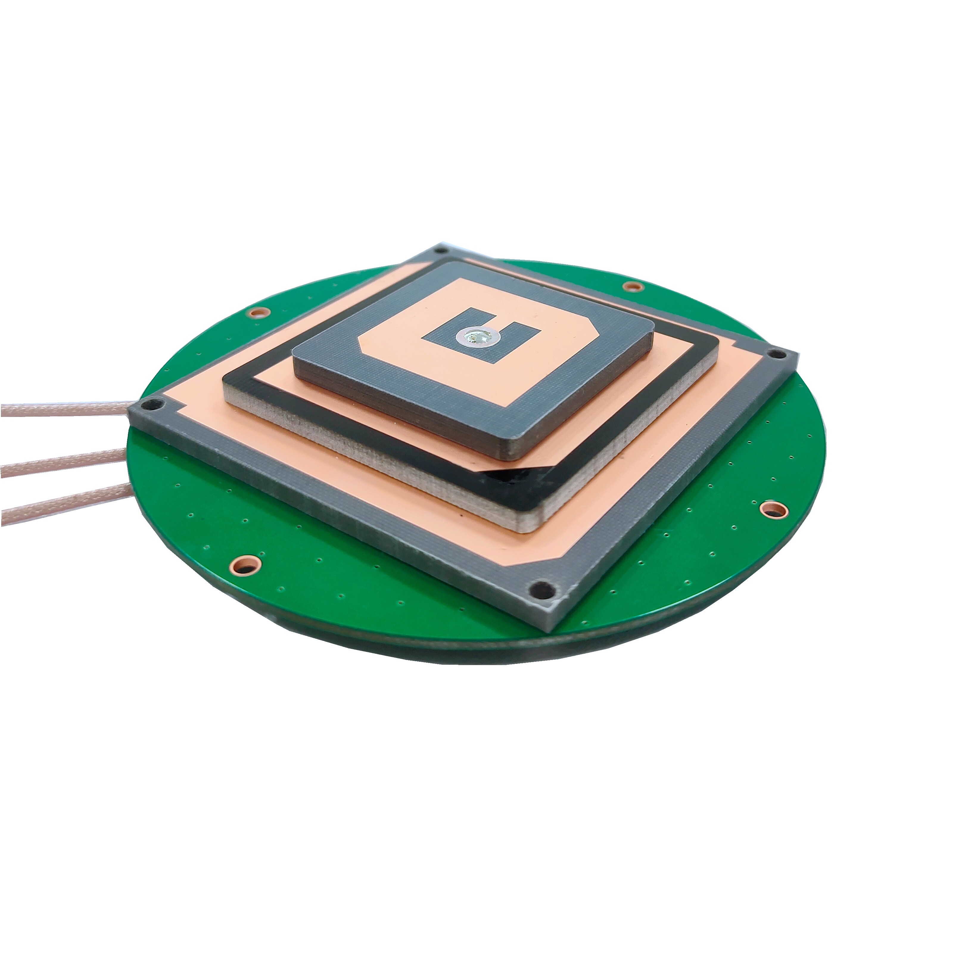
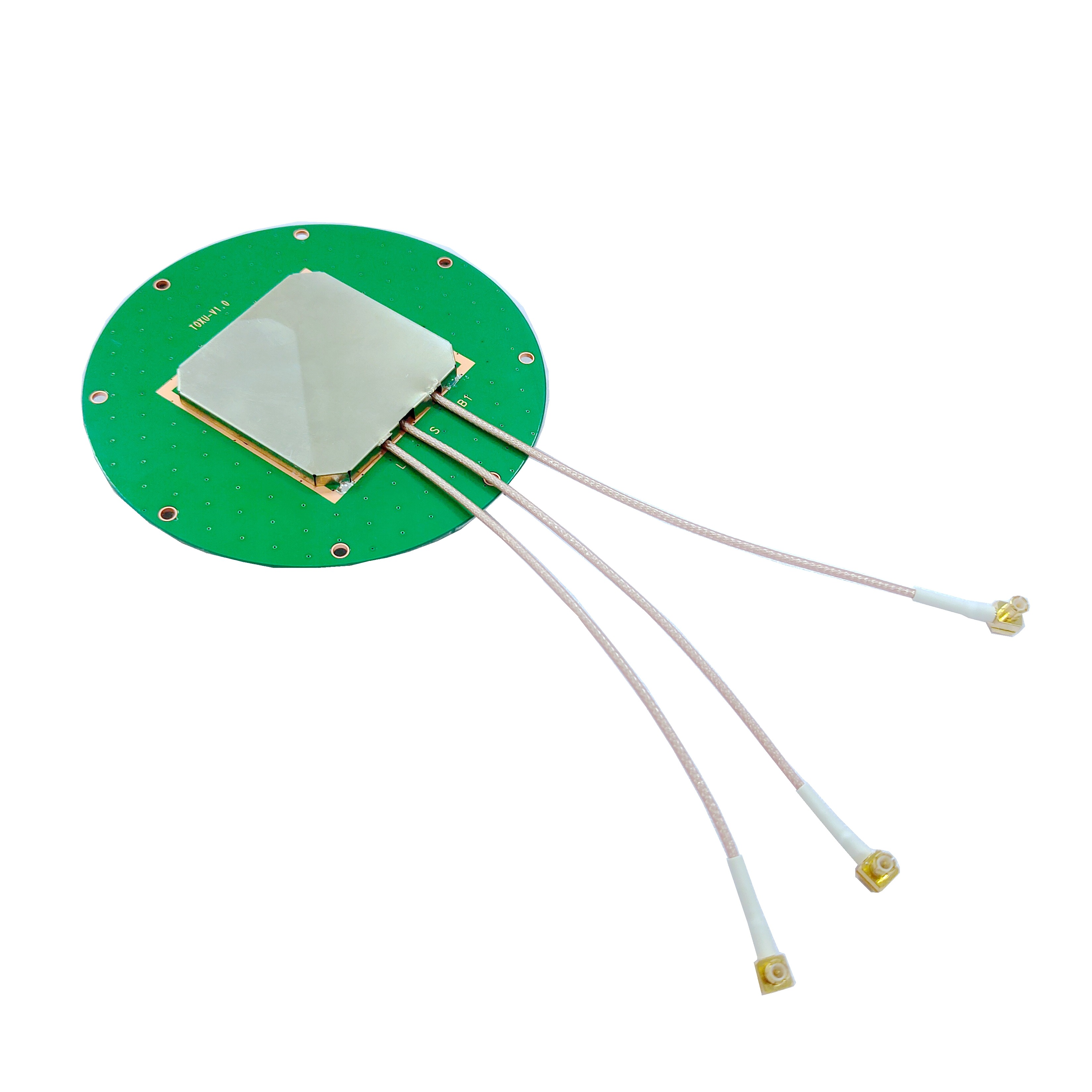
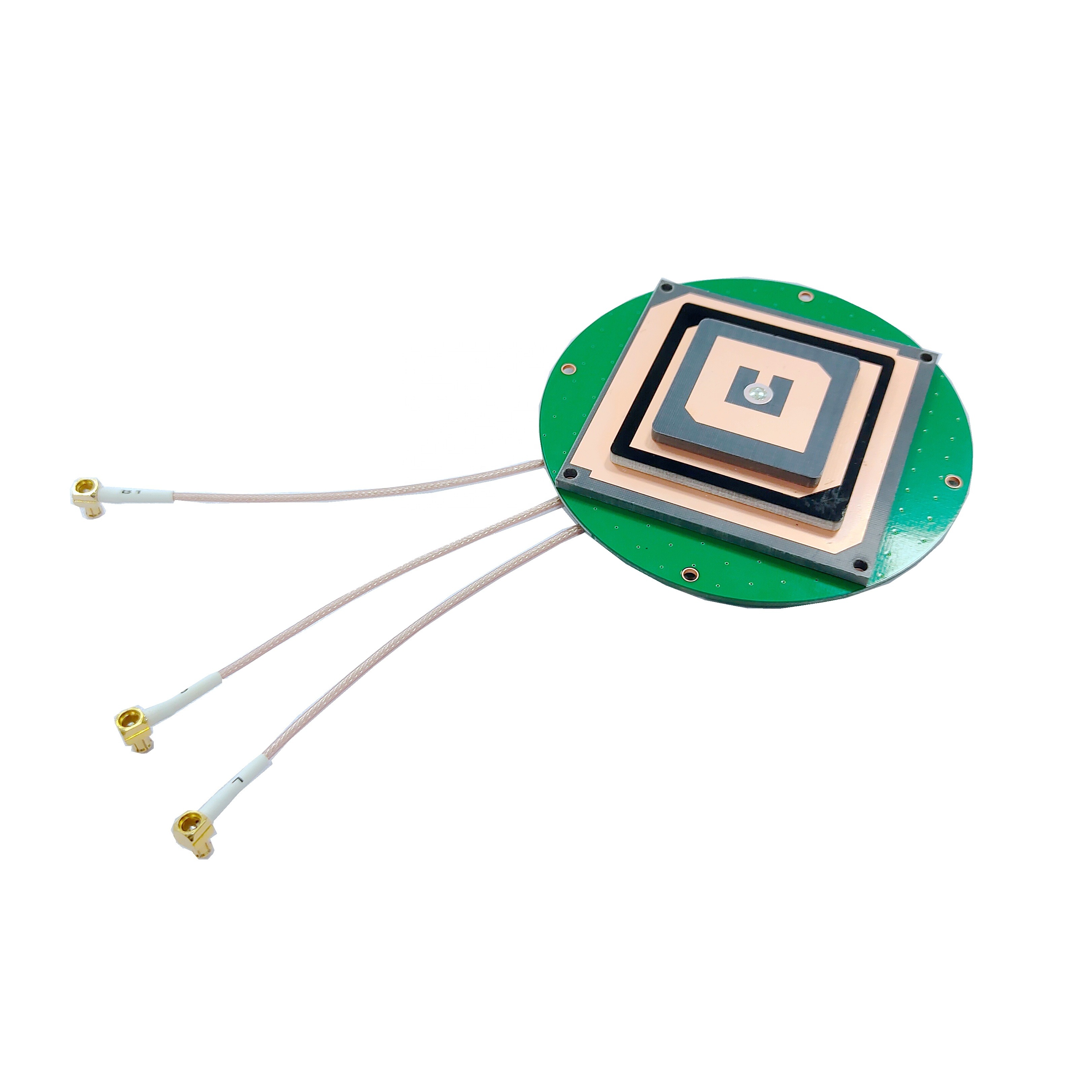
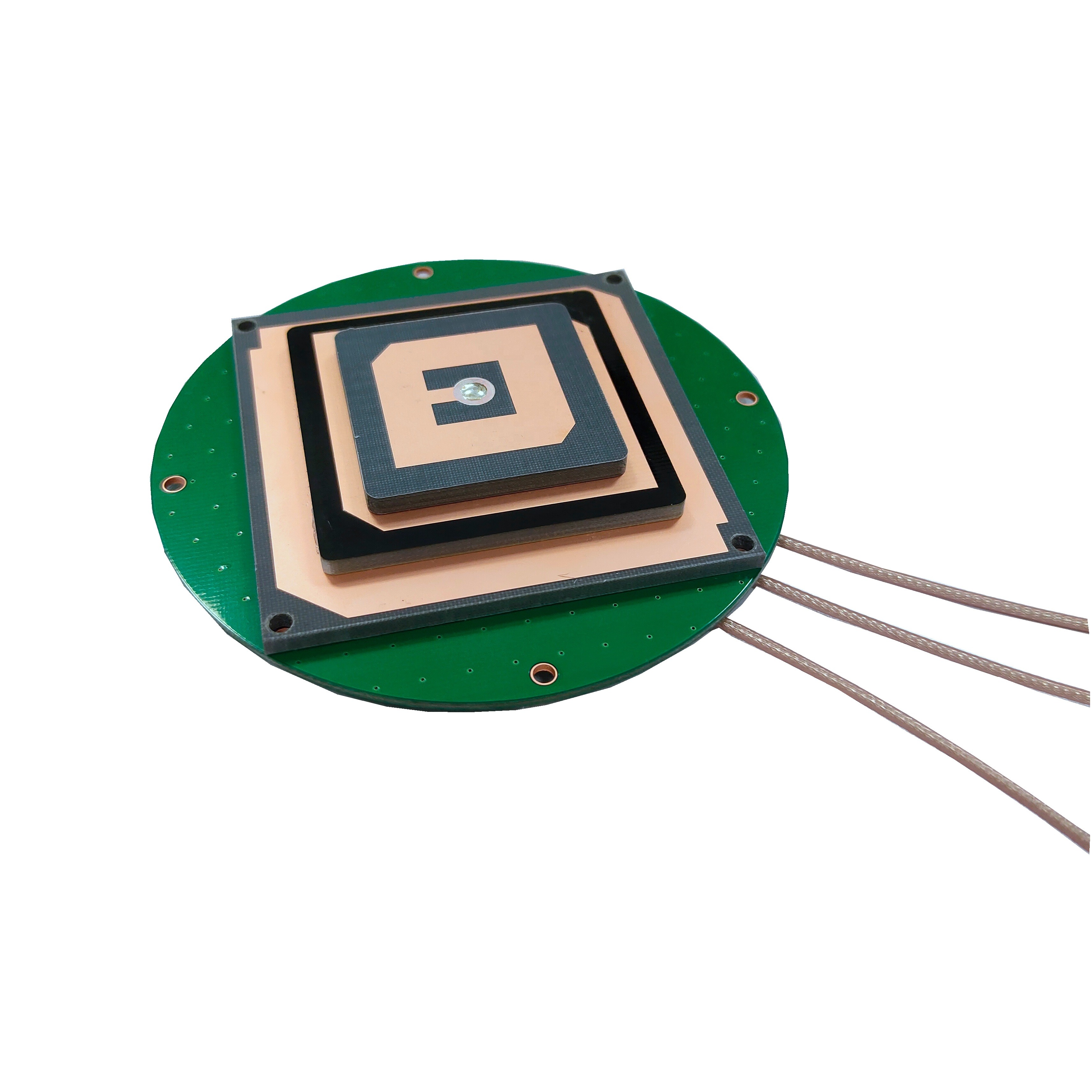
2.1.2 Antenna Design
Antennas must efficiently capture multi-band signals while rejecting multipath interference. Common designs include:
Dual-Band Patch Antennas: Stacked layers for L1/L2 or L1/L5 frequencies, often with a ground plane to minimize reflections.
Helical Antennas: Compact and omnidirectional, suitable for small drones but less efficient than patch antennas.
Choke Ring Antennas: Advanced designs with corrugated edges to suppress multipath errors in urban environments.
2.1.3 Processor and IMU Integration
Microcontroller Unit (MCU): High-performance MCUs (e.g., STM32H757) handle RTK calculations, sensor fusion, and communication with the flight controller.
Inertial Measurement Unit (IMU): A 6-axis IMU (accelerometer + gyroscope) and magnetometer (e.g., ICM42688 + RM3100) provide inertial data for dead reckoning during GNSS outages.
Barometer: A MEMS barometer (e.g., MS5611) measures altitude for vertical positioning stability.
2.1.4 Communication Interface
CAN FD / UART: High-speed interfaces (up to 8 Mbps) ensure low-latency data transfer to the flight controller.
Wi-Fi / Bluetooth: Optional wireless connectivity for configuration and firmware updates.
NTRIP Client: Built-in support for receiving RTCM corrections via cellular or radio links.
2.1.5 Power Management
Low-Dropout Regulators (LDOs): Stabilize voltage inputs to sensitive components.
Sleep Modes: Reduce power consumption during idle periods (e.g., landing or hovering).
Battery Monitoring: Some modules include voltage sensors to prevent brownouts during high-current maneuvers.
2.2 Example: CubePilot Here4 Module
The Here4 exemplifies state-of-the-art design:
Dimensions: 16 × 68 × 10 mm, weighing 60g.
Chipset: u-blox ZED-F9P with STM32H757 MCU.
Antenna: Dual-band patch antenna with choke ring for multipath suppression.
Sensors: ICM42688 IMU, RM3100 magnetometer, MS5611 barometer.
Interfaces: DroneCAN, UART, I2C, SPI, and ProfiLED status indicators.
Power: 3.3–5.5V input, 1.2W typical consumption.
2.3 Thermal and Environmental Considerations
Thermal Management: Heat sinks or conductive pads dissipate heat from the MCU and RF front-end.
IP Rating: Modules are often rated IP67 or higher for dust and water resistance.
Shock Resistance: Vibration-damping mounts protect sensitive components during rough landings.
3.1 RTK Fundamentals
RTK achieves centimeter accuracy by comparing measurements from a rover (drone-mounted receiver) and a base station (fixed reference receiver):
Base Station Setup: The base station, positioned at a known coordinate, receives GNSS signals and calculates errors (e.g., ionospheric delay, satellite clock bias).
Correction Transmission: Errors are broadcast to the rover via radio (e.g., 915 MHz/2.4 GHz) or cellular networks (NTRIP protocol).
Rover Processing: The rover applies corrections to its raw measurements, resolving integer ambiguities in carrier-phase data to determine precise relative positioning.
3.2 Multi-Band Enhancements
Multi-band receivers improve RTK performance by:
Mitigating Ionospheric Errors: L1/L2 or L1/L5 signals travel at different speeds through the ionosphere; their differential delay provides correction terms.
Accelerating Ambiguity Resolution: Redundant measurements across frequencies reduce the time to achieve a "RTK fix" (from minutes to seconds).
Improving Multipath Rejection: Higher frequencies (e.g., L5) are less susceptible to reflections from buildings or terrain.
3.3 Sensor Fusion and Kalman Filtering
To maintain stability during GNSS outages, RTK modules fuse IMU and barometer data with GNSS positions using a Kalman filter:
Prediction Step: The filter estimates the drone’s next state (position, velocity, attitude) based on IMU readings.
Update Step: GNSS measurements correct the prediction, improving accuracy over time.
Adaptive Tuning: The filter dynamically adjusts noise parameters based on environmental conditions (e.g., urban vs. open sky).
3.4 Example Workflow: Drone Surveying Mission
Pre-Flight Setup: The base station is placed at a surveyed point; the drone’s RTK module connects to the correction stream.
RTK Fix Acquisition: Within 10–30 seconds, the module achieves centimeter accuracy.
Flight Execution: The drone follows a pre-programmed path, capturing geotagged images or LiDAR data with 2 cm horizontal accuracy.
Post-Flight Processing: No corrections are needed; data is immediately exportable to GIS software.
4.1 Advantages
Unmatched Precision: Centimeter-level accuracy enables applications like 3D mapping, volumetric calculations, and structural inspection.
Real-Time Operation: Eliminates the need for post-processing, saving hours of labor.
Redundancy: Multi-constellation support ensures signal availability even if one system fails.
Scalability: Modules can be integrated into drones of all sizes, from sub-250g micro-UAVs to heavy-lift platforms.
4.2 Challenges
High Initial Cost: Multi-band RTK modules are 3–5x more expensive than single-frequency receivers.
Infrastructure Dependency: RTK networks require base stations or cellular coverage, which may be lacking in rural areas.
Complexity: Setting up and maintaining RTK systems demands technical expertise.
Signal Obstruction: Dense foliage or urban canyons can cause temporary outages, forcing reliance on IMU dead reckoning.
5.1 Current Applications
Surveying & Mapping: Drones generate 3D models with GSD as fine as 1 cm/pixel, replacing traditional LiDAR in many cases.
Precision Agriculture: Variable-rate applications and crop health monitoring optimize yields while reducing costs.
Construction & Mining: Drones monitor stockpile volumes, track progress, and detect deviations from blueprints.
Infrastructure Inspection: High-resolution imaging identifies cracks in bridges, pipelines, and wind turbines.
5.2 Future Trends
Miniaturization: Advances in chipset integration will shrink modules to fit sub-250g drones, expanding applications in delivery and surveillance.
AI-Enhanced Processing: Onboard neural networks will improve ambiguity resolution in challenging environments, reducing reliance on base stations.
5G Integration: Low-latency 5G networks will enable cloud-based RTK corrections, eliminating the need for local base stations.
Quantum GNSS: Emerging quantum sensors promise sub-millimeter accuracy, though commercialization remains decades away.
Conclusion
Multi-band RTK GNSS embedded modules are transforming the drone industry by delivering unprecedented precision and efficiency. While challenges like cost and infrastructure persist, advancements in miniaturization, AI, and 5G are poised to overcome these barriers, unlocking new use cases in autonomous logistics, smart cities, and environmental monitoring. As the technology matures, RTK-equipped drones will transition from niche tools to mainstream enablers of a data-driven world, where every centimeter counts. Manufacturers like CubePilot, u-blox, and DJI are at the forefront of this revolution, proving that the future of navigation is not just about knowing where you are—but knowing it with absolute certainty.

 86 0755 2819 9597
Lucy Yang | lucy.y@toxutech.com
Nicole Li | nicole@toxutech.com
Dotty Zhao | sales04@toxutech.com
Global Business Director / Sales Team / Global Operations


 En
En Cn
Cn Korean
 Home >


