

-
Products -PCBA Manufacturing RF Connectors RF Cable Assemblys Embedded Antennas External Antennas Positioning Chips and Modules
RF Connectors

RF Cable Assemblys
Embedded Antennas
External Antennas
Positioning Chips and Modules


 Language


Language


In the ever - evolving landscape of geospatial technology, Waterproof Precision Surveying GNSS Antennas have emerged as crucial components for accurate and reliable positioning in a wide range of applications. GNSS, which stands for Global Navigation Satellite System, encompasses constellations like GPS (Global Positioning System), GLONASS (Globalnaya Navigatsionnaya Sputnikovaya Sistema), Galileo, and BeiDou. These systems rely on a network of satellites orbiting the Earth to provide location, velocity, and time information to receivers on the ground.
Precision surveying demands the highest level of accuracy in determining positions, often down to the centimeter or even millimeter level. This is essential for applications such as land surveying, construction of large - scale infrastructure projects (bridges, buildings, and roads), and monitoring of geological movements. However, surveying activities are frequently carried out in diverse environmental conditions, including rain, snow, and high humidity. This is where waterproof GNSS antennas play a pivotal role.
Waterproof precision surveying GNSS antennas are designed to withstand harsh weather conditions while maintaining their high - performance capabilities. They are engineered with specialized materials and construction techniques to prevent water ingress, ensuring the integrity of the internal components. These antennas are not only waterproof but also often dust - proof and resistant to other environmental factors such as temperature variations and UV radiation.
The market for waterproof precision surveying GNSS antennas has been growing steadily, driven by the increasing need for accurate geospatial data in various industries. As technology continues to advance, these antennas are becoming more compact, lightweight, and energy - efficient, while also offering enhanced accuracy and reliability.
2.1 Enclosure Materials
The enclosure of a waterproof precision surveying GNSS antenna is typically made from materials with excellent water - resistant and durable properties. Common materials include high - grade plastics such as polycarbonate and acrylonitrile butadiene styrene (ABS), which offer a good balance of strength, impact resistance, and water tightness. In some high - end models, metal enclosures, often aluminum alloys, are used. Aluminum is lightweight yet strong, and it can be anodized to provide additional protection against corrosion.
The enclosure is designed with a seamless or highly - sealed structure. Gaskets made from rubber or silicone are commonly used to create a watertight seal around openings such as cable entries and access panels. These gaskets are compressed between mating surfaces to prevent water from seeping in. In addition, some antennas use epoxy or other sealants to further enhance the water - proofing at critical joints.
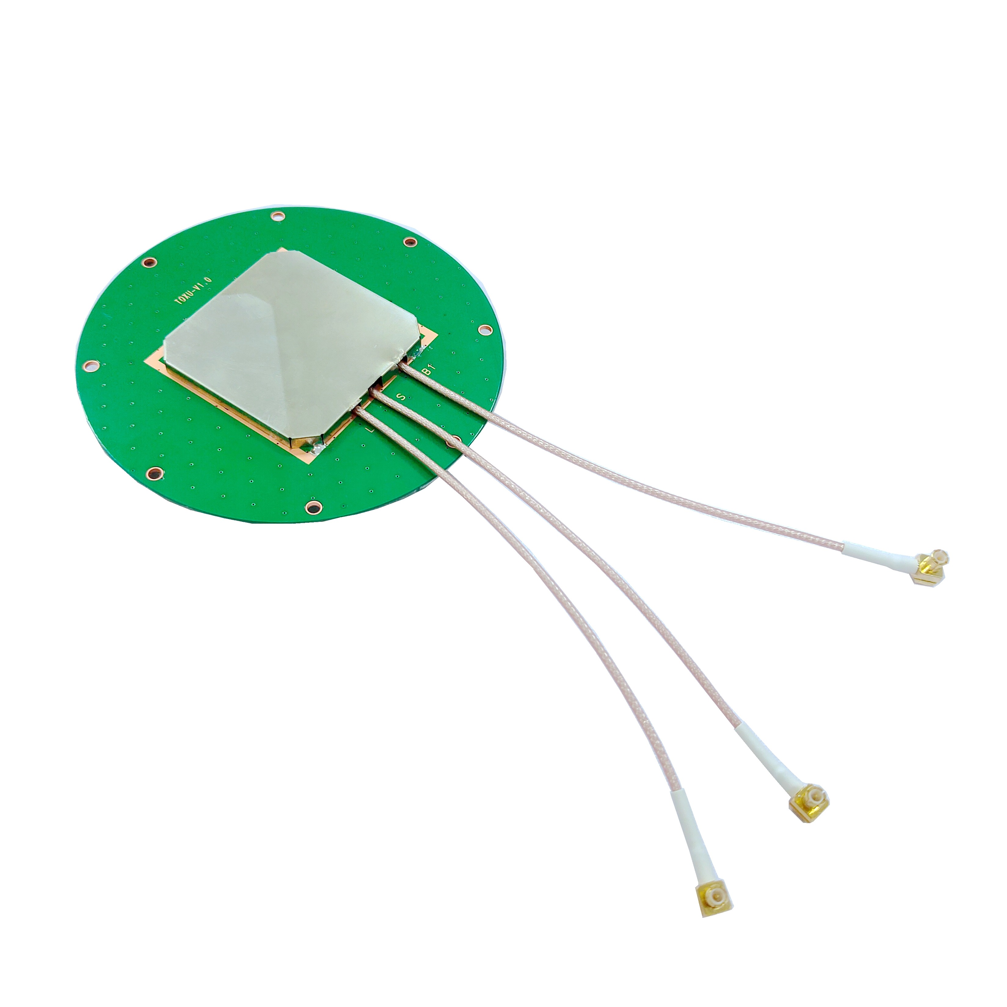
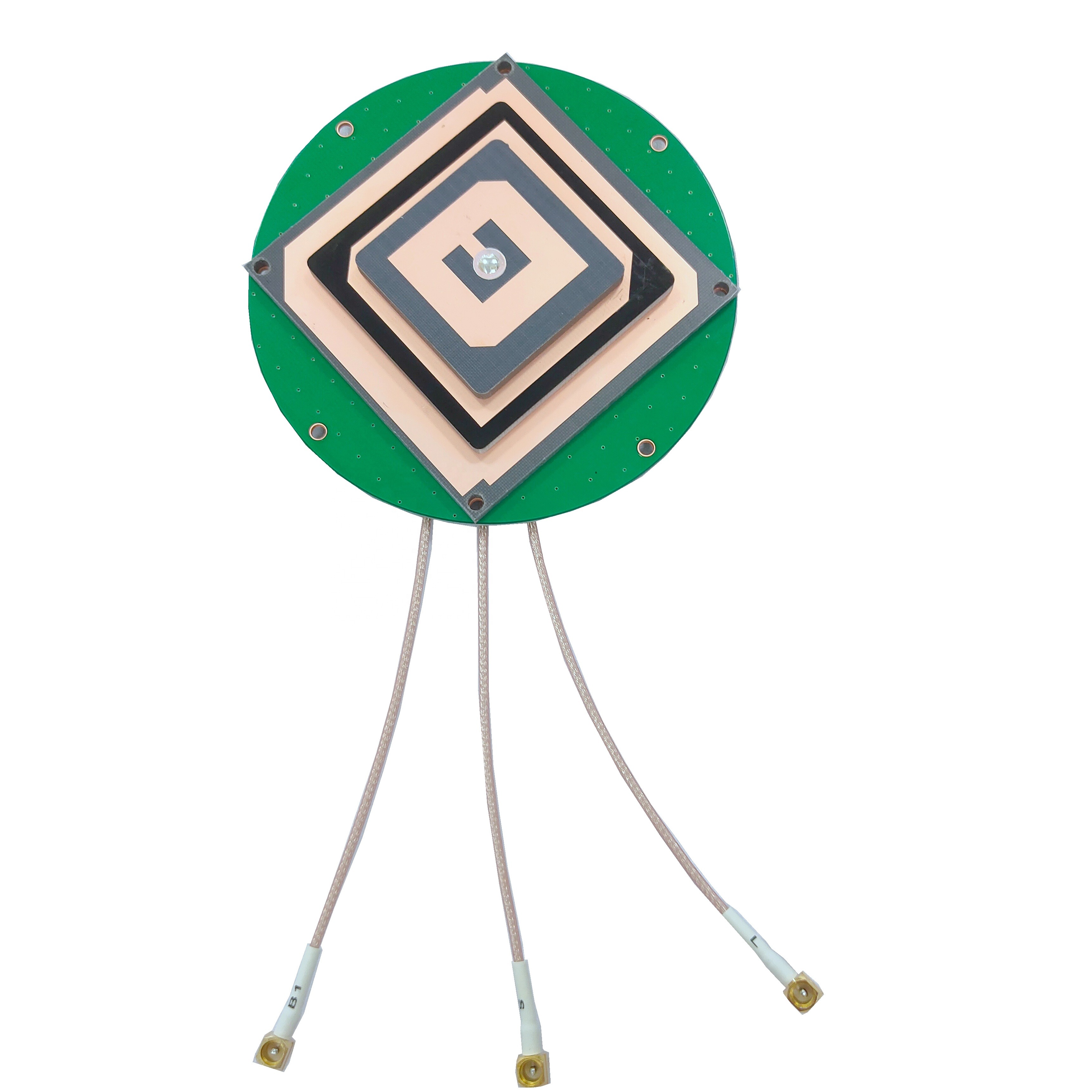
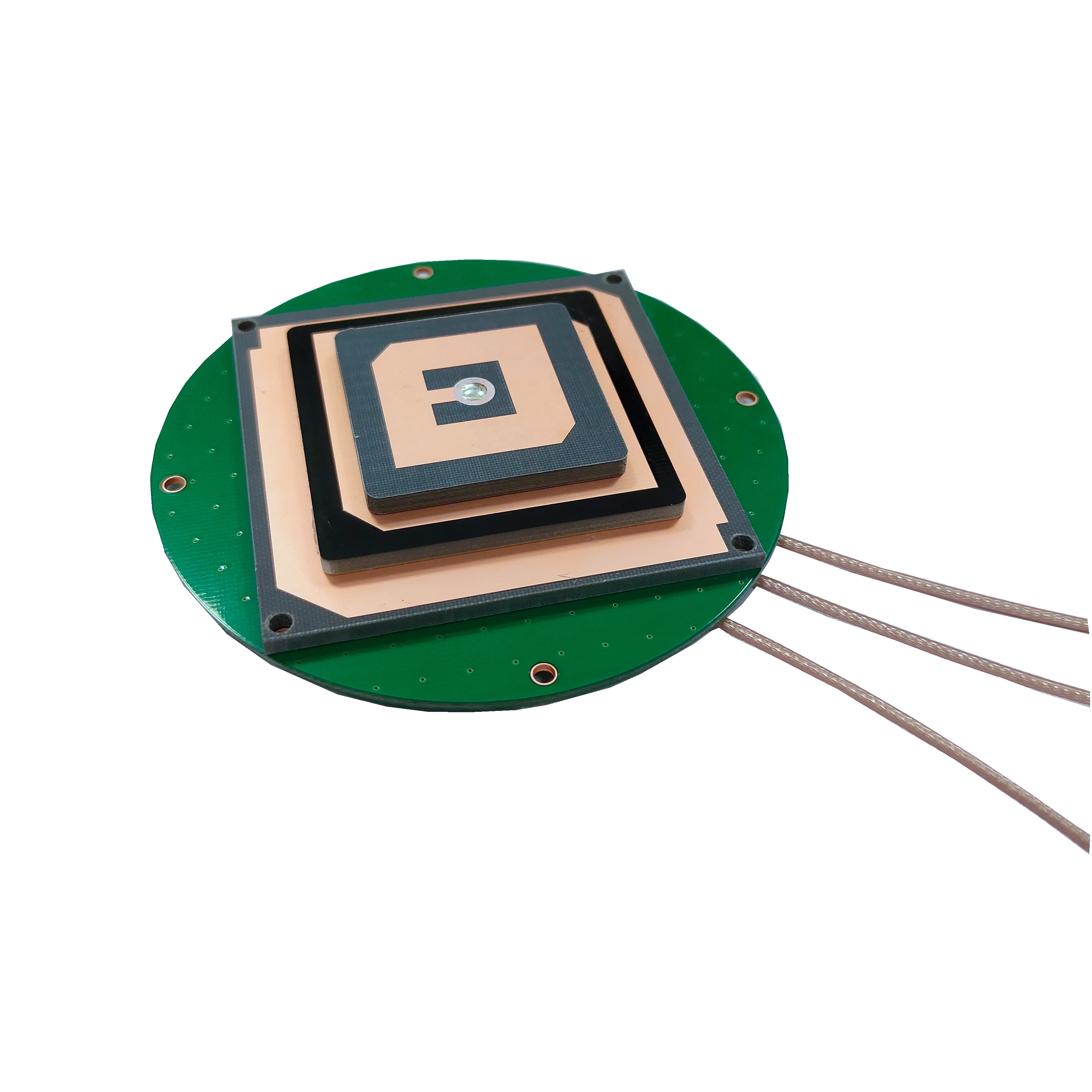
2.2 Antenna Elements
The antenna elements within the enclosure are responsible for receiving the satellite signals. These elements are designed to be highly sensitive to the specific frequencies used by GNSS satellites. For multi - frequency antennas, which are common in precision surveying, multiple sets of antenna elements are integrated. Each set is tuned to a different frequency band, such as L1, L2, and L5 for GPS, or their equivalent in other GNSS constellations.
The antenna elements are often arranged in a specific pattern to optimize signal reception. For example, a circularly - polarized antenna design is widely used in GNSS antennas. Circular polarization helps in reducing the impact of signal reflections (multipath interference), which can degrade the accuracy of the positioning. The antenna elements are carefully designed to have a consistent phase center, which is crucial for achieving high - precision measurements. Any variation in the phase center can introduce errors in the calculated position.
2.3 Internal Electronics
Inside the antenna, there are various electronic components that play important roles. A low - noise amplifier (LNA) is one of the key components. The LNA boosts the weak satellite signals received by the antenna elements without adding significant noise. This is essential as the signals from satellites are extremely weak by the time they reach the Earth's surface. The LNA is carefully shielded within the antenna enclosure to protect it from electromagnetic interference (EMI) and water.
There are also filters to select the desired GNSS frequencies and reject unwanted signals from other sources. These filters help in improving the signal - to - noise ratio and ensuring that only the relevant satellite signals are processed. In some advanced antennas, there are additional components for signal conditioning and pre - processing before the signals are sent to the GNSS receiver for further processing.
2.4 Mounting and Installation Features
Waterproof precision surveying GNSS antennas are designed to be easily mounted and installed in different environments. They often come with standard mounting interfaces, such as tripod mounts or pole - mounting brackets. These mounts are designed to be stable and secure, ensuring that the antenna remains in the correct orientation for optimal signal reception.
Some antennas are equipped with leveling features, such as built - in spirit levels or electronic leveling sensors. This allows the surveyor to quickly and accurately level the antenna, which is important for maintaining consistent signal reception. Additionally, the cable connections are designed to be waterproof and easy to connect and disconnect. They often use specialized connectors with rubber seals to prevent water from entering the cable and reaching the internal components of the antenna.
3.1 Satellite Signal Reception
GNSS satellites orbit the Earth at high altitudes and continuously transmit radio signals. These signals carry information about the satellite's position, time, and other data necessary for positioning. Waterproof precision surveying GNSS antennas are designed to capture these signals. The antenna elements, as mentioned earlier, are sensitive to the specific frequencies of the GNSS signals. When a satellite signal reaches the antenna, it induces a small electrical current in the antenna elements.
The antenna is designed to be highly efficient in receiving signals from satellites at different elevation and azimuth angles. A wide - beamwidth design is often employed to ensure that signals from satellites across a large portion of the sky can be received. This is important as the position of the satellites relative to the antenna on the ground is constantly changing. By being able to receive signals from multiple satellites simultaneously, the antenna provides the necessary data for accurate positioning calculations.
3.2 Signal Processing within the Antenna
Once the satellite signals are received by the antenna elements, they are fed into the internal electronics of the antenna. The low - noise amplifier (LNA) immediately boosts the weak signals. As the signals are extremely weak, typically in the range of nanovolts, the LNA is crucial for making the signals strong enough to be processed further. After amplification, the signals pass through filters.
The filters are designed to select the specific GNSS frequencies of interest and reject other unwanted signals. For example, in a multi - frequency GNSS antenna, there are filters for each frequency band (L1, L2, L5, etc.). This filtering process helps in improving the signal - to - noise ratio. The filtered and amplified signals are then pre - processed within the antenna. This pre - processing may include tasks such as signal conditioning to make the signals more suitable for transmission to the GNSS receiver.
3.3 Interaction with GNSS Receivers
The pre - processed signals from the antenna are transmitted to a GNSS receiver via a coaxial cable or other suitable means of communication. The GNSS receiver is responsible for the more complex processing of the signals to determine the position of the antenna. The receiver measures the time it takes for the signals to travel from the satellites to the antenna. This time measurement is based on the principle of time - of - flight.
By knowing the position of the satellites (which is transmitted as part of the satellite signals) and the time it takes for the signals to reach the antenna, the receiver can calculate the distance (range) between the antenna and each satellite. Using a process called trilateration (or multilateration when more than three satellites are involved), the receiver determines the position of the antenna on the Earth's surface. The antenna and the receiver work in tandem, with the antenna providing the raw satellite signals and the receiver performing the calculations to obtain the accurate position.
4.1 Advantages
4.1.1 High Precision
Waterproof precision surveying GNSS antennas are capable of providing extremely accurate positioning data. In many cases, they can achieve centimeter - level or even sub - centimeter - level accuracy. This high precision is essential for applications such as land surveying, where accurate boundary determination is crucial. In construction projects, it enables precise alignment of structures, reducing errors and costly rework. For example, in the construction of a high - rise building, the use of a waterproof precision surveying GNSS antenna can ensure that the foundation is laid exactly where it should be, with minimal deviation.
4.1.2 Weather Resistance
The waterproof design of these antennas allows them to operate effectively in various weather conditions. Whether it is heavy rain, snow, or high humidity, the antenna can continue to receive satellite signals without any degradation in performance. This is a significant advantage over non - waterproof antennas, which may malfunction or experience reduced signal reception in wet conditions. For instance, in a long - term geological monitoring project in a mountainous area where rain is frequent, a waterproof GNSS antenna can provide continuous and reliable data on ground movements.
4.1.3 Durability
These antennas are built to be durable. The materials used in their construction, such as high - grade plastics or aluminum alloys, can withstand harsh environmental conditions, including temperature variations, UV radiation, and mechanical stress. This durability ensures a long service life, reducing the need for frequent replacements. In a large - scale infrastructure project that may span several years, a durable waterproof GNSS antenna can be relied upon to provide consistent performance throughout the project.
4.1.4 Versatility
Waterproof precision surveying GNSS antennas are versatile and can be used in a wide range of applications. They are suitable for land surveying, construction, agriculture (precision farming), marine navigation, and even in some aerospace applications. Their ability to work with different GNSS constellations (GPS, GLONASS, Galileo, BeiDou) further enhances their versatility. For example, a farmer can use a waterproof GNSS antenna in precision agriculture to accurately map the boundaries of fields and apply fertilizers and pesticides precisely.
4.2 Challenges
4.2.1 Multipath Interference
Multipath interference is a major challenge in GNSS signal reception, and it also affects waterproof precision surveying GNSS antennas. Multipath occurs when the satellite signals bounce off nearby objects (such as buildings, trees, or water surfaces) before reaching the antenna. These reflected signals can interfere with the direct signals, causing errors in the time - of - flight measurements and thus reducing the accuracy of the positioning. In urban areas with many tall buildings or in areas with a lot of vegetation, multipath interference can be particularly severe. Antenna designers use various techniques such as circular polarization and multi - path rejection boards to mitigate this problem, but it remains a persistent challenge.
4.2.2 Signal Blockage
Another challenge is signal blockage. Obstacles such as mountains, large buildings, or dense forests can block the satellite signals from reaching the antenna. In such cases, the antenna may not be able to receive signals from enough satellites to perform accurate positioning. For example, in a deep - valley surveying project, the surrounding mountains may block some of the satellite signals, making it difficult to obtain a reliable position fix. To overcome this, surveyors often need to find suitable locations with a clear view of the sky or use additional techniques such as differential GNSS or inertial navigation systems in combination with the GNSS antenna.
4.2.3 Cost
High - performance waterproof precision surveying GNSS antennas can be relatively expensive. The use of advanced materials, complex manufacturing processes, and high - quality internal components contribute to the cost. This cost factor may limit their adoption in some applications, especially in budget - constrained projects. For example, a small - scale land surveying company may find it difficult to invest in a large number of these high - end antennas. Manufacturers are constantly working on ways to reduce the cost without sacrificing performance, such as through economies of scale and the development of more cost - effective manufacturing techniques.
4.2.4 Compatibility
With the increasing number of GNSS constellations and the development of new technologies, ensuring compatibility can be a challenge. Waterproof precision surveying GNSS antennas need to be compatible with different GNSS receivers and software. In some cases, there may be issues with signal compatibility, especially when using antennas with older or less - common receivers. Additionally, as new features and capabilities are added to GNSS systems, antennas need to be updated to take advantage of these improvements, which may require additional investment and development efforts.
5.1 Applications
5.1.1 Land Surveying
In land surveying, waterproof precision surveying GNSS antennas are indispensable. They are used to accurately measure property boundaries, create topographic maps, and establish control points. Surveyors can use these antennas to quickly and precisely determine the elevation and coordinates of points on the ground. This data is then used for various purposes, such as urban planning, infrastructure development, and land - use management. For example, when planning a new residential area, surveyors use GNSS antennas to accurately map the terrain and determine the best locations for roads, buildings, and utilities.
5.1.2 Construction
In the construction industry, these antennas play a crucial role in ensuring the accuracy of large - scale projects. They are used for site layout, foundation setting, and the alignment of structures during construction. For instance, in the construction of a bridge, a waterproof GNSS antenna can be used to precisely position the bridge piers, ensuring that they are in the correct location and at the right elevation. This helps in preventing structural problems and ensures the safety and durability of the finished bridge.
5.1.3 Precision Agriculture
Precision agriculture has seen a significant increase in the use of GNSS technology, and waterproof precision surveying GNSS antennas are at the heart of this application. Farmers use these antennas to precisely map their fields, monitor crop growth, and apply fertilizers and pesticides more efficiently. By knowing the exact location of different areas within the field, farmers can adjust their farming practices based on the specific needs of the crops. For example, they can apply more fertilizer in areas where the soil is less fertile, reducing waste and increasing crop yields.
5.1.4 Marine Navigation
In marine applications, waterproof GNSS antennas are used for ship navigation, offshore surveying, and underwater mapping. They provide accurate position information, which is essential for safe navigation, especially in areas with complex coastlines or shallow waters. For example, a fishing vessel can use a GNSS antenna to precisely locate fishing grounds, while a research ship can use it for underwater mapping and exploration.
5.2 Future Trends
5.2.1 Higher Precision
The trend in the future is towards even higher precision in GNSS positioning. New technologies and algorithms are being developed to further reduce the errors in positioning. For example, advancements in multi - frequency and multi - constellation processing are expected to improve the accuracy of waterproof precision surveying GNSS antennas. In addition, the use of real - time kinematic (RTK) and precise point positioning (PPP) techniques is likely to become more widespread, enabling sub - centimeter - level accuracy in more applications.
5.2.2 Integration with Other Technologies
There is a growing trend of integrating GNSS antennas with other technologies. For example, combining GNSS with inertial navigation systems (INS) can provide more continuous and reliable positioning, especially in situations where GNSS signals are blocked. Integration with sensors such as LiDAR (Light Detection and Ranging) and cameras can also enhance the capabilities of geospatial data collection. In the future, we may see more smart devices that integrate GNSS antennas with other sensors to provide a comprehensive solution for various applications.
5.2.3 Miniaturization and Energy Efficiency
As technology advances, there is a demand for smaller and more energy - efficient GNSS antennas. Miniaturization will make it easier to integrate these antennas into smaller devices, such as drones and handheld surveying equipment. At the same time, improving energy efficiency will reduce the power consumption of the antennas, extending the battery life of portable devices. New materials and design techniques are being explored to achieve these goals.
5.2.4 Enhanced Compatibility
With the continued development of new GNSS constellations and the evolution of existing ones, enhanced compatibility will be a key trend. Waterproof precision surveying GNSS antennas will need to be able to work seamlessly with a wider range of GNSS signals and receivers. This will require manufacturers to invest in research and development to ensure that their antennas can adapt to the changing technological landscape.
Conclusion
Waterproof precision surveying GNSS antennas have become an essential part of modern geospatial technology. Their ability to provide accurate positioning data in harsh environmental conditions has made them indispensable in various industries, including land surveying, construction, agriculture, and marine navigation. Through careful design and construction, these antennas are able to withstand water, dust, and other environmental factors while maintaining high - performance capabilities.
The working principles of these antennas, from satellite signal reception to interaction with GNSS receivers, are well - understood and continuously refined. They offer significant advantages such as high precision, weather resistance, durability, and versatility. However, they also face challenges such as multipath interference, signal blockage, cost, and compatibility, which the industry is actively working to overcome.
Looking to the future, the applications of waterproof precision surveying GNSS antennas are expected to expand further, driven by trends such as higher precision, integration with other technologies, miniaturization, energy efficiency, and enhanced compatibility. As technology continues to advance, these antennas will play an even more crucial role in enabling accurate and reliable geospatial data collection and positioning, opening up new possibilities for a wide range of industries and applications.

 86 0755 2819 9597
Lucy Yang | lucy.y@toxutech.com
Nicole Li | nicole@toxutech.com
Dotty Zhao | sales04@toxutech.com
Global Business Director / Sales Team / Global Operations


 En
En Cn
Cn Korean
 Home >


