

-
Products -PCBA Manufacturing RF Connectors RF Cable Assemblys Embedded Antennas External Antennas Positioning Chips and Modules
RF Connectors

RF Cable Assemblys
Embedded Antennas
External Antennas
Positioning Chips and Modules


 Language


Language


In the field of geospatial measurement and land surveying, accuracy and reliability are paramount. Surveying Global Navigation Satellite System (GNSS) antennas serve as the critical interface between satellites and surveying equipment, enabling the capture of precise location data that forms the foundation of mapping, construction, and land management projects. These specialized antennas are designed to receive signals from multiple GNSS constellations—including GPS, GLONASS, Galileo, and BeiDou—with exceptional sensitivity and stability, even in challenging environmental conditions.
In the field of geospatial measurement and land surveying, accuracy and reliability are paramount. Surveying Global Navigation Satellite System (GNSS) antennas serve as the critical interface between satellites and surveying equipment, enabling the capture of precise location data that forms the foundation of mapping, construction, and land management projects. These specialized antennas are designed to receive signals from multiple GNSS constellations—including GPS, GLONASS, Galileo, and BeiDou—with exceptional sensitivity and stability, even in challenging environmental conditions.
Surveying GNSS antennas differ significantly from consumer - grade antennas used in smartphones or navigation devices. They are engineered to minimize errors caused by signal interference, multipath effects, and environmental factors, ensuring sub - centimeter to meter - level positioning accuracy depending on the surveying method (such as Real - Time Kinematic (RTK) or Precise Point Positioning (PPP)). Their robust construction allows them to withstand harsh outdoor conditions, including extreme temperatures, rain, dust, and vibrations, making them indispensable tools for field surveyors.
The evolution of surveying GNSS antennas has paralleled advancements in satellite navigation technology. Early antennas were large, heavy, and limited to single - frequency reception, restricting their accuracy and versatility. Modern antennas, by contrast, are compact, lightweight, and support multiple frequencies and constellations, enabling faster signal acquisition, improved accuracy, and operation in diverse geographic regions. Today, surveying GNSS antennas are integral to a wide range of applications, from cadastral surveying and infrastructure development to environmental monitoring and disaster response.
Design and Construction
Core Design Features
Surveying GNSS antennas are meticulously designed to prioritize accuracy, signal stability, and durability. Key design features include:
Multi - Frequency Support: Unlike single - frequency antennas, modern surveying antennas operate across multiple GNSS frequency bands, such as GPS L1/L2/L5, GLONASS G1/G2, Galileo E1/E5a/E5b, and BeiDou B1/B2. This multi - frequency capability allows for the mitigation of ionospheric and tropospheric errors, which are major sources of positioning inaccuracy. By comparing signals across different frequencies, surveying receivers can model and correct these atmospheric disturbances, significantly improving measurement precision.
Low Phase Center Variation: The phase center of an antenna is the point where the received satellite signals are electrically processed. For surveying applications, it is critical that the phase center remains stable regardless of the satellite's elevation or azimuth angle. Surveying GNSS antennas are designed with minimal phase center variation (often less than 1 mm), ensuring that measurements are consistent across all satellite positions. This stability is achieved through careful design of the radiating element and ground plane, as well as calibration during manufacturing.
Omnidirectional Radiation Pattern: To receive signals from satellites in all parts of the sky, surveying antennas feature a nearly omnidirectional radiation pattern, with particularly strong reception in the upper hemisphere. This ensures that signals from low - elevation satellites (near the horizon) are captured as effectively as those from high - elevation satellites, maximizing the number of usable satellites and improving positioning reliability in challenging environments such as urban canyons or mountainous terrain.
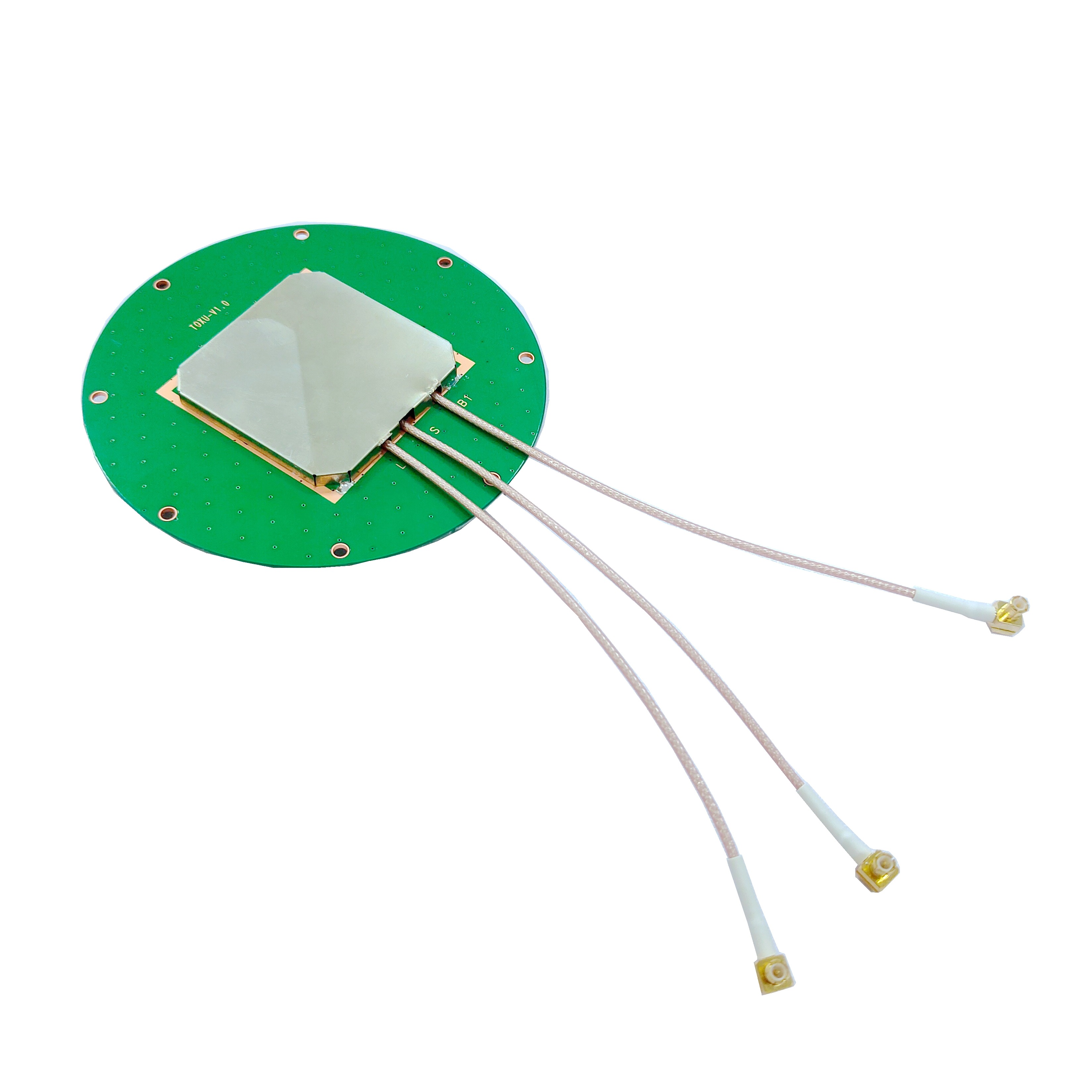
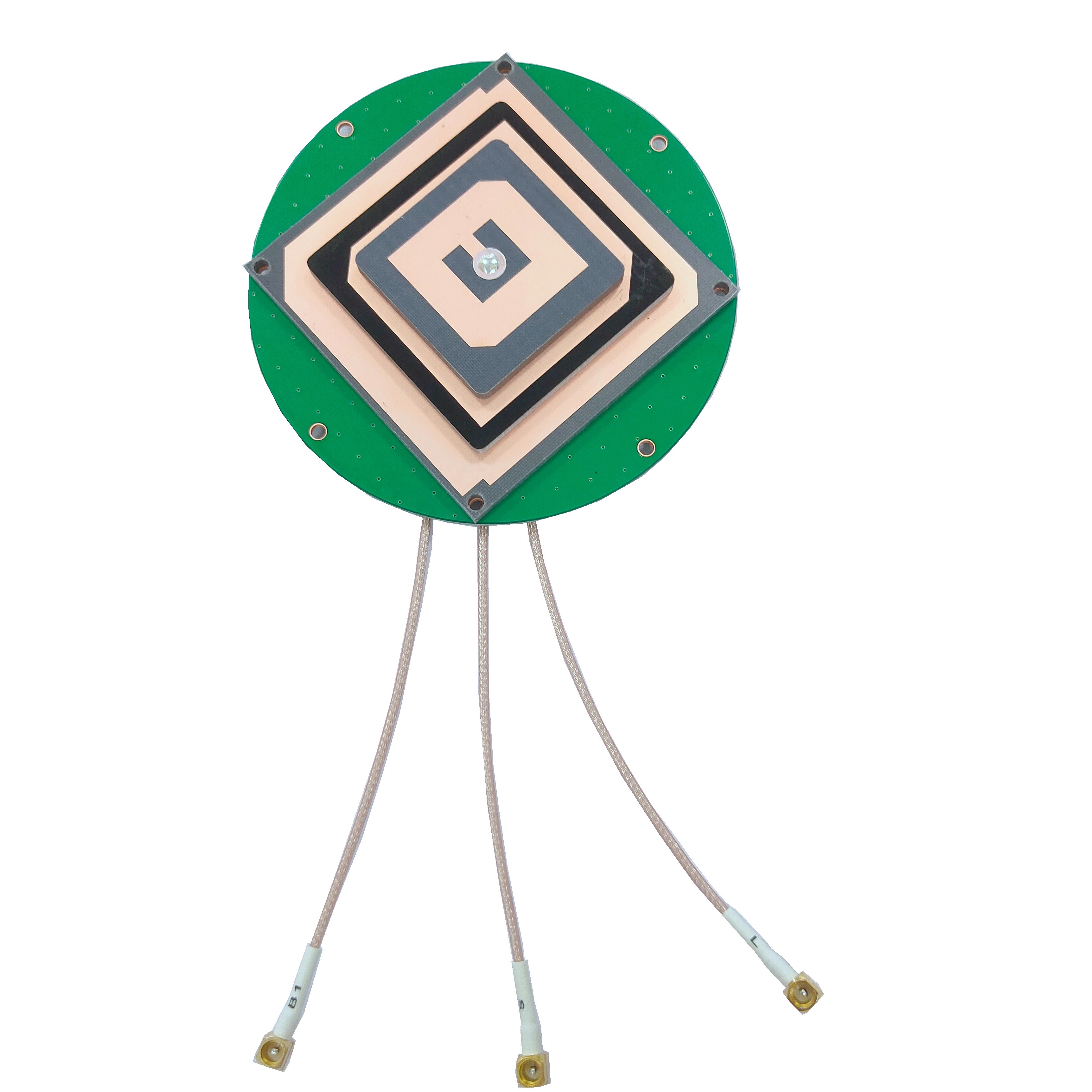
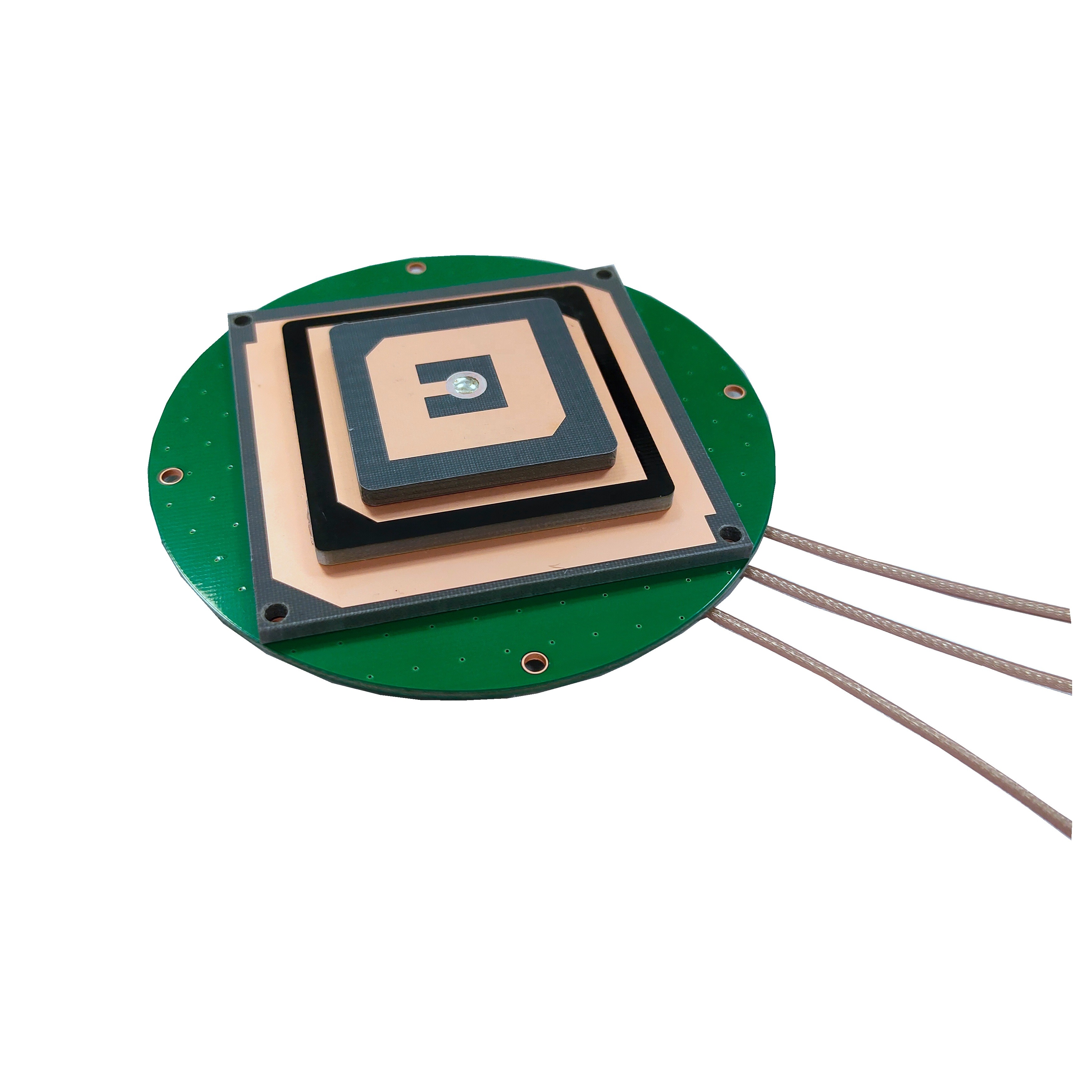
The construction of a surveying GNSS antenna involves several key components working in harmony to achieve high performance:
Radiating Element: The radiating element is typically a planar patch or array of patches made from high - conductivity materials such as copper or gold - plated copper. These patches are mounted on a dielectric substrate (e.g., ceramic or fiberglass - reinforced plastic) with a high dielectric constant, which allows for compact design while maintaining efficient signal reception. The shape and arrangement of the patches are optimized to resonate at the target GNSS frequencies, ensuring maximum signal capture.
Ground Plane: A large, flat ground plane (usually aluminum or stainless steel) is positioned beneath the radiating element. The ground plane serves multiple purposes: it reflects downward - traveling signals back to the radiating element, enhancing gain; it shields the antenna from electromagnetic interference (EMI) from the surveying equipment or the ground; and it provides mechanical stability. In some designs, the ground plane is integrated into the antenna's base, which may also include mounting hardware for attaching to surveying poles or tripods.
Radome: The radome is a protective cover that encloses the radiating element and ground plane. Made from materials such as fiberglass, plastic, or composite materials, the radome is designed to be transparent to GNSS frequencies while protecting the internal components from dust, water, UV radiation, and physical damage. The radome's shape is aerodynamically optimized to minimize wind resistance during fieldwork, and it often features a low - profile design to reduce interference with the antenna's radiation pattern.
Low - Noise Amplifier (LNA): Integrated into the antenna housing, the LNA amplifies weak satellite signals before they are transmitted to the surveying receiver via a coaxial cable. The LNA is designed with a very low noise figure (typically less than 1.5 dB) to ensure that the amplified signals retain a high signal - to - noise ratio (SNR), which is critical for accurate positioning. Some antennas also include band - pass filters to suppress out - of - band interference from sources such as cellular towers or radio transmitters.
Cable and Connector: Surveying GNSS antennas are connected to receivers via low - loss coaxial cables, which minimize signal attenuation over long distances (up to 10 meters or more). The cables are often ruggedized to withstand bending, stretching, and exposure to the elements. High - quality connectors (such as TNC or SMA) ensure a secure, weatherproof connection between the antenna and the cable, preventing signal loss or degradation.
Surveying GNSS antennas operate on the fundamental principle of capturing and processing electromagnetic signals transmitted by GNSS satellites, but their design ensures that this process is optimized for high - precision measurement. Here is a detailed breakdown of their working principles:
Signal Reception: GNSS satellites orbit the Earth at altitudes of approximately 20,000 km, transmitting continuous radio frequency (RF) signals in the L - band. These signals contain timing information (from atomic clocks on board the satellites) and orbital data (ephemeris) that describe the satellite's position in space. The surveying antenna's radiating element is tuned to resonate at the specific frequencies of these signals, allowing it to efficiently absorb the electromagnetic energy.
Signal Amplification and Filtering: The received signals are extremely weak (typically around - 130 dBm) when they reach the antenna, due to the long distance they travel. The integrated LNA amplifies these signals by 20 - 30 dB to a level that can be processed by the surveying receiver. Simultaneously, band - pass filters remove unwanted frequencies and interference, ensuring that only the desired GNSS signals are passed to the receiver.
Phase Measurement: Unlike consumer antennas, which primarily use code - phase measurements (based on the satellite's pseudorandom noise code) for positioning, surveying antennas focus on carrier - phase measurements. The carrier wave of the GNSS signal is a continuous sine wave with a known frequency, and by measuring the phase of this wave at the antenna, surveyors can determine the distance to the satellite with much greater precision. The phase center stability of the antenna ensures that these phase measurements are consistent across all satellite angles, minimizing errors.
Error Mitigation: Surveying GNSS antennas are designed to mitigate common sources of positioning error:
Multipath Interference: Signals reflected off nearby surfaces (such as buildings, trees, or the ground) can reach the antenna at the same time as the direct signal, causing constructive or destructive interference. The antenna's ground plane and radome design help to reduce multipath by absorbing or reflecting unwanted signals, and the receiver uses algorithms to further filter out multipath effects.
Atmospheric Errors: Ionospheric and tropospheric delays affect the speed of GNSS signals as they pass through the Earth's atmosphere. By receiving signals on multiple frequencies, the antenna and receiver can model these delays and correct for them. For example, the ionospheric delay is frequency - dependent, so comparing L1 and L2 signals allows the receiver to calculate and remove this error.
Thermal and Mechanical Effects: Changes in temperature or mechanical stress (such as wind or vibration) can cause minor shifts in the antenna's phase center. High - quality construction materials and thermal stabilization techniques minimize these effects, ensuring that the phase center remains stable during measurements.
Data Transmission to Receiver: The amplified, filtered, and phase - measured signals are transmitted to the surveying receiver via the coaxial cable. The receiver uses these signals from multiple satellites (typically 4 or more) to calculate the antenna's position using trilateration. By measuring the difference in phase between signals from different satellites, the receiver can achieve centimeter - level accuracy in RTK mode (when paired with a base station) or decimeter - level accuracy in PPP mode (using correction data from global networks).
Advantages
Surveying GNSS antennas offer numerous advantages that make them indispensable in geospatial measurement:
High Precision: The primary advantage of surveying GNSS antennas is their ability to provide high - precision positioning data, often at the sub - centimeter level when used with RTK technology. This level of accuracy is essential for applications such as cadastral surveying (defining property boundaries), construction staking (marking positions for infrastructure), and deformation monitoring (tracking small movements in buildings or bridges).
Efficiency and Productivity: Compared to traditional surveying methods (such as total stations), GNSS - based surveying with specialized antennas is faster and more efficient. Surveyors can collect data from multiple points in a single setup, reducing the time spent moving equipment and setting up benchmarks. This increased productivity is particularly valuable for large - scale projects, such as mapping vast rural areas or monitoring extensive infrastructure networks.
Versatility Across Environments: Surveying GNSS antennas are designed to perform reliably in diverse environments, from open rural areas to dense urban centers. Their multi - frequency support and omnidirectional radiation patterns allow them to capture signals even in challenging conditions, such as under tree canopies or near tall buildings. This versatility reduces the need for additional equipment or manual adjustments, streamlining the surveying process.
Compatibility with Multiple Constellations: Modern surveying antennas support multiple GNSS constellations, including GPS, GLONASS, Galileo, and BeiDou. This multi - constellation capability increases the number of visible satellites, improving positioning reliability and reducing the risk of signal loss. In regions where one constellation is weak (e.g., GPS in high - latitude areas), signals from other constellations (e.g., GLONASS) can be used to maintain accuracy.
Durability and Longevity: Built to withstand harsh field conditions, surveying GNSS antennas are rugged and durable. Their weatherproof radomes, corrosion - resistant materials, and robust construction ensure that they can operate in extreme temperatures (- 40°C to + 70°C), heavy rain, snow, and dust. This durability reduces maintenance costs and ensures that the antennas can be used for years, even in demanding environments.
Challenges
Despite their advantages, surveying GNSS antennas face several challenges that must be addressed to ensure accurate measurements:
Multipath Interference: While designed to mitigate multipath, surveying antennas can still be affected by strong reflections in urban canyons, near water bodies, or around large structures. Multipath can cause positioning errors of several centimeters, which is problematic for high - precision applications. Surveyors often need to take additional measurements or use specialized software to filter out multipath effects, adding time to the surveying process.
Signal Blockage: In dense forests, narrow valleys, or indoors, the antenna may receive too few satellite signals to calculate a precise position. This is known as "GNSS denial" and can halt surveying work until the antenna is moved to a location with better sky visibility. In such cases, surveyors may need to use alternative methods (e.g., total stations) or deploy additional equipment (e.g., repeaters) to extend signal coverage.
Cost: High - quality surveying GNSS antennas are significantly more expensive than consumer - grade antennas, with prices ranging from several hundred to several thousand dollars. This cost can be a barrier for small surveying firms or organizations with limited budgets, though the long - term benefits in accuracy and productivity often justify the investment.
Calibration Requirements: To maintain accuracy, surveying GNSS antennas must be regularly calibrated to account for phase center variations and other environmental factors. Calibration involves comparing the antenna's performance to a known standard, which can be time - consuming and costly. Failure to calibrate can lead to systematic errors in measurements, compromising the quality of survey data.
Power and Cable Management: The LNA in surveying antennas requires a power source (typically provided by the surveying receiver via the coaxial cable), and long cables can introduce signal loss. Surveyors must ensure that the cable is properly routed and protected from damage, and that the receiver provides a stable power supply to the antenna. In remote areas, battery - powered receivers may struggle to maintain power for extended periods, limiting surveying time.
Applications
Surveying GNSS antennas are used in a wide range of applications across various industries, leveraging their precision and reliability:
Cadastral Surveying: Cadastral surveys define property boundaries, land ownership, and legal descriptions of land parcels. Surveying GNSS antennas provide the high accuracy needed to establish these boundaries, ensuring that they are legally defensible and free from disputes. In many countries, cadastral surveys using GNSS technology have replaced traditional methods, reducing time and costs while improving accuracy.
Construction and Infrastructure: In construction, surveying GNSS antennas are used for staking out foundations, roads, bridges, and other structures. They ensure that infrastructure is built according to design specifications, minimizing errors and rework. During construction, antennas are also used to monitor the alignment and elevation of structures, ensuring that they meet safety standards. For example, in road construction, GNSS - equipped graders use surveying antennas to maintain precise slopes and elevations, improving the quality of the finished road.
Topographic Mapping: Topographic maps depict the natural and man - made features of a landscape, including elevation, vegetation, and buildings. Surveying GNSS antennas enable efficient data collection for these maps, allowing surveyors to quickly capture the coordinates of thousands of points. This data is then used to create 3D models and maps, which are essential for urban planning, environmental management, and disaster response.
Deformation Monitoring: Structures such as dams, bridges, and skyscrapers can shift over time due to factors like tectonic activity, soil settlement, or environmental stress. Surveying GNSS antennas are used to monitor these deformations with millimetric precision, providing early warning of potential failures. By collecting regular measurements, engineers can assess the structural health of a facility and take corrective action if necessary.
Agriculture and Precision Farming: In agriculture, surveying GNSS antennas are used to create precise field maps, guide farm equipment, and monitor crop health. By mapping soil properties and crop yields, farmers can apply fertilizers and pesticides more efficiently, reducing costs and environmental impact. GNSS - guided tractors and harvesters use surveying antennas to follow precise paths, ensuring uniform planting and harvesting.
Disaster Response and Emergency Management: After natural disasters such as earthquakes, floods, or landslides, surveying GNSS antennas are used to assess damage, map affected areas, and plan relief efforts. They can quickly provide accurate coordinates of damaged infrastructure, displaced populations, and safe zones, helping emergency responders allocate resources effectively.
Future Trends
The future of surveying GNSS antennas is shaped by advancements in satellite technology, materials science, and data processing. Key trends include:
Increased Constellation Support: As new GNSS constellations (such as India's NavIC and Japan's QZSS) expand their coverage, surveying antennas will support an even broader range of frequencies and satellites. This will further improve positioning reliability, especially in regions with historically limited GNSS coverage, such as the polar regions or remote areas.
Integration with Artificial Intelligence (AI): AI algorithms will be integrated into surveying systems to enhance antenna performance. For example, AI can predict and mitigate multipath interference by analyzing historical data and real - time signal patterns, improving accuracy in challenging environments. AI - powered calibration tools may also automate the calibration process, reducing downtime and ensuring consistent performance.
Miniaturization and Portability: Advances in materials science (such as the use of metamaterials and nanotechnology) will lead to smaller, lighter surveying antennas without sacrificing performance. These compact antennas will be easier to transport and deploy, making them ideal for drone - based surveying and backpack - mounted systems used in remote areas.
Enhanced Anti - Jamming Capabilities: With the growing threat of GNSS jamming and spoofing, future surveying antennas will incorporate advanced anti - jamming technologies. These may include adaptive beamforming (which focuses reception on legitimate satellites), frequency hopping (which avoids jammed frequencies), and encryption (which verifies the authenticity of satellite signals). These features will ensure that surveying operations can continue even in hostile electromagnetic environments.
Energy Harvesting: To extend the battery life of portable surveying equipment, future antennas may integrate energy harvesting technologies. For example, solar - powered LNAs or antennas that capture ambient RF energy could reduce reliance on external power sources, enabling longer surveying missions in remote areas.
Integration with 5G and IoT: The convergence of GNSS with 5G and the Internet of Things (IoT) will enable new surveying applications. 5G's low latency and high bandwidth will allow for real - time data transmission and processing, enabling collaborative surveying projects where multiple antennas share data simultaneously. IoT - connected antennas could also provide continuous, autonomous monitoring of structures or landscapes, sending alerts when changes are detected.
Conclusion
Surveying GNSS antennas are essential tools in modern geospatial measurement, enabling precise, efficient, and reliable positioning across a wide range of applications. Their sophisticated design—incorporating multi - frequency support, low phase center variation, and robust construction—allows them to overcome environmental challenges and deliver the accuracy required for critical projects in construction, land management, and disaster response.
While challenges such as multipath interference, signal blockage, and cost remain, ongoing advancements in technology are addressing these issues. Future trends, including increased constellation support, AI integration, and miniaturization, promise to further enhance the capabilities of surveying GNSS antennas, making them even more versatile and indispensable

 86 0755 2819 9597
Lucy Yang | lucy.y@toxutech.com
Nicole Li | nicole@toxutech.com
Dotty Zhao | sales04@toxutech.com
Global Business Director / Sales Team / Global Operations


 En
En Cn
Cn Korean
 Home >


