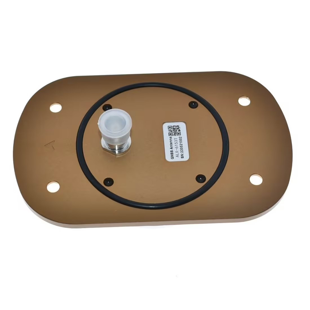
Real-Time Kinematic (RTK) technology has revolutionized high-precision navigation across various domains, and its integration into aviation—particularly for unmanned aerial systems (UAS), general aviation, and emerging urban air mobility (UAM)—is gaining significant momentum. The RTK aviation antenna plays a pivotal role in enabling centimeter-level positioning accuracy by receiving and processing carrier-phase GNSS signals in real time. Unlike conventional aviation navigation systems that rely on VOR, ILS, or basic GNSS for meter-level accuracy, RTK-equipped aircraft utilize a specialized antenna system to achieve unprecedented positional fidelity, essential for autonomous operations, precision landing, and dense airspace integration.
An RTK aviation antenna is specifically engineered to meet the rigorous demands of flight, including high vibration, wide temperature ranges, electromagnetic interference (EMI), and dynamic orientation changes. These antennas are typically mounted on the aircraft’s fuselage or wingtip to ensure optimal sky visibility and minimal signal obstruction. They are designed to support dual or multi-frequency reception (L1, L2, L5) across multiple GNSS constellations such as GPS, GLONASS, Galileo, and BeiDou, ensuring robust satellite tracking and redundancy. The integration of RTK requires a continuous data stream of differential corrections, either from a ground-based reference station, a network of CORS (Continuously Operating Reference Stations), or via satellite-based augmentation systems (SBAS) enhanced for RTK performance.
The core function of the RTK aviation antenna is to provide a stable, low-noise interface between the sky and the onboard GNSS receiver. It must maintain consistent phase center stability—the point from which signal measurements are taken—across varying flight attitudes and environmental conditions. Any phase center variation introduces measurement bias, which can compromise the integrity of RTK solutions. Therefore, aviation-grade RTK antennas are meticulously calibrated and tested to ensure minimal phase center offset (PCO) and phase center variation (PCV), critical parameters for high-accuracy applications.
These antennas are often circularly polarized, typically right-hand circular polarization (RHCP), to match the polarization of GNSS satellite signals and maximize signal capture efficiency. They also feature high gain in the upper hemisphere to prioritize signals from satellites above the horizon, while suppressing multipath reflections from the aircraft body or ground. Advanced models incorporate integrated low-noise amplifiers (LNA), bandpass filters, and EMI shielding to enhance signal quality and reject interference from onboard avionics, radar, and communication systems.
RTK aviation antennas are increasingly being adopted in unmanned aircraft systems (UAS) used for precision agriculture, surveying, infrastructure inspection, and delivery logistics, where repeatable flight paths and accurate geotagging are essential. In manned aviation, they support experimental and light aircraft in achieving enhanced situational awareness and automated approach capabilities, especially in areas lacking traditional instrument landing systems. Moreover, with the development of electric vertical takeoff and landing (eVTOL) vehicles for urban air mobility, RTK antennas are expected to become standard components for safe, precise navigation in complex urban environments.
As aviation moves toward greater automation and digitalization, the role of the RTK aviation antenna will expand beyond mere positioning. It will serve as a foundational sensor for cooperative air traffic management, drone traffic coordination (UTM), and seamless integration into next-generation air navigation infrastructure. Its ability to deliver real-time, high-integrity positioning data makes it a cornerstone of the future smart aviation ecosystem.
Design and Construction of RTK Aviation Antenna for Aircraft Navigation
The design and construction of an RTK aviation antenna involve a sophisticated blend of RF engineering, mechanical robustness, and environmental resilience tailored to the unique challenges of flight. Unlike consumer-grade GNSS antennas, aviation models must meet stringent performance, safety, and certification standards, including DO-160 for environmental testing and RTCA DO-316 for GNSS equipment.
At the heart of the antenna is the radiating element, which can take several forms depending on the application: patch antennas, helical antennas, or choke ring designs. Patch antennas are widely used due to their low profile, directional gain, and ease of integration. They consist of a conductive patch over a ground plane, separated by a dielectric substrate, and are tuned to resonate at GNSS frequencies. For RTK applications, multi-layer stacked patches are often employed to achieve dual or triple-band operation (L1/L2/L5), enabling ionospheric correction and improved ambiguity resolution.
Helical antennas, while less common in commercial aviation, offer high gain and excellent axial ratio, making them suitable for high-dynamic applications where signal stability during rapid maneuvers is critical. Choke ring antennas, though bulky, are used in ground reference stations and high-end aerial survey platforms for their exceptional multipath rejection, achieved through concentric grooves that suppress surface waves.
The ground plane is a critical component that influences radiation pattern, gain, and phase center stability. In aviation antennas, the ground plane is either integrated into the antenna base or designed to interface with the aircraft’s conductive surface. Its size and shape are optimized to ensure a uniform radiation pattern and minimize pattern distortion caused by the aircraft’s structure.
To protect against environmental hazards, the antenna is enclosed in a radome made of RF-transparent materials such as fiberglass-reinforced polymer or specialized composites. The radome must withstand extreme temperatures (-55°C to +85°C), UV radiation, moisture, and mechanical impact without degrading signal transmission. It is often hydrophobic and anti-static to prevent water accumulation and dust buildup.
Integrated front-end electronics include a low-noise amplifier (LNA) and bandpass filters. The LNA, located close to the feed point, amplifies weak GNSS signals (as low as -130 dBm) while adding minimal noise (noise figure <1 dB). Bandpass filters centered on GNSS bands reject out-of-band interference from radar, communication systems, and onboard electronics. Some designs incorporate SAW filters or cavity filters for superior selectivity.
Power is delivered via bias-T, allowing DC voltage to be supplied through the coaxial cable, simplifying installation. The antenna is connected to the GNSS receiver using low-loss coaxial cable (e.g., RG-400 or LMR-200) to minimize signal attenuation.
Mechanically, the antenna is designed for vibration resistance and aerodynamic compatibility. Mounting brackets are made from corrosion-resistant materials like aluminum or stainless steel and include EMI gaskets to ensure electrical continuity with the airframe. The entire assembly undergoes rigorous testing for shock, vibration, humidity, and salt fog exposure.
Finally, the antenna is calibrated for phase center stability using anechoic chamber measurements or robotic calibration systems. This ensures that PCO and PCV values are known and can be compensated in the GNSS receiver firmware, a requirement for high-accuracy RTK applications.
The RTK aviation antenna functions as the primary sensor in a high-precision navigation system, capturing GNSS signals and delivering them to the receiver with minimal distortion. GNSS satellites transmit RHCP signals in L1 (1575.42 MHz), L2 (1227.60 MHz), and L5 (1176.45 MHz) bands. The antenna’s RHCP design ensures maximum signal capture efficiency. As the aircraft moves, the antenna maintains a stable radiation pattern focused on the upper hemisphere, ensuring continuous satellite tracking.
Incoming signals pass through the radome and induce current in the radiating element. The signal is then filtered to remove interference from radar, ATC transponders, and other avionics. The filtered signal is amplified by the LNA and transmitted via coaxial cable to the GNSS receiver. The receiver processes carrier-phase measurements from both the aircraft (rover) and a reference station, resolving integer ambiguities to achieve centimeter-level accuracy.
Phase center stability is maintained through symmetrical design and calibration. The antenna suppresses multipath using directional gain and ground plane design. Bias-T powers the LNA over the same cable, reducing wiring complexity. The result is a continuous, high-fidelity signal stream essential for safe, precise aircraft navigation.
The integration of Real-Time Kinematic (RTK) aviation antennas into aircraft navigation systems offers transformative benefits in positioning accuracy, operational efficiency, and flight autonomy. However, this advanced technology also introduces significant engineering and operational challenges that must be addressed to ensure safety, reliability, and regulatory compliance.
One of the most compelling advantages of RTK aviation antennas is their ability to deliver centimeter-level positioning accuracy in real time. Unlike conventional GNSS systems that provide meter-level precision, RTK enables aircraft to determine their position with sub-5 cm accuracy by resolving carrier-phase ambiguities using differential corrections from a nearby reference station or network. This level of precision is critical for applications such as automated landings, precision approach paths, and formation flying, particularly in environments where traditional Instrument Landing Systems (ILS) are unavailable or cost-prohibitive to install.
Another key benefit is enhanced situational awareness and flight safety. With highly accurate and continuous positioning data, pilots and autonomous flight systems can maintain tighter control over flight paths, avoid terrain and obstacles, and operate safely in congested airspace. This is especially valuable for unmanned aerial vehicles (UAVs) and emerging electric vertical takeoff and landing (eVTOL) aircraft in urban air mobility (UAM) scenarios, where precise navigation between buildings and landing pads is essential.
RTK aviation antennas also support reduced reliance on ground infrastructure. While RTK traditionally requires a local base station, advancements in Network RTK (NRTK) and satellite-delivered corrections (e.g., via L-band or cellular networks) allow aircraft to receive real-time corrections over wide areas without deploying dedicated ground equipment. This scalability makes RTK suitable for regional operations, long-range UAV missions, and mobile base stations on ships or remote outposts.
The multi-constellation and multi-frequency capability of modern RTK antennas further enhances reliability. By simultaneously tracking GPS, GLONASS, Galileo, and BeiDou satellites across L1, L2, and L5 bands, these antennas ensure a high number of visible satellites, improving signal availability and geometric diversity (lower DOP values). Multi-frequency reception also enables real-time ionospheric delay correction, a major source of error in single-frequency systems, thereby improving solution integrity.
Additionally, RTK antennas contribute to operational efficiency and cost savings. In aerial surveying, precision agriculture, and infrastructure inspection, centimeter-accurate geotagging eliminates the need for ground control points (GCPs), reducing fieldwork time and labor costs. For commercial drone operators, this translates into faster mission turnaround and higher data quality.
Despite these advantages, several challenges remain. Electromagnetic interference (EMI) from onboard avionics, radar, motors, and power systems can degrade GNSS signal quality, leading to cycle slips or loss of RTK fix. Even with shielding and filtering, EMI remains a persistent issue, particularly in compact UAVs where components are densely packed.
Signal blockage and multipath interference are also significant concerns. The aircraft’s own structure—such as wings, fuselage, or antennas—can obstruct satellite signals, especially at low elevation angles. Conductive materials like carbon fiber can attenuate or reflect GNSS signals, further complicating reception. Multipath, caused by signal reflections off the aircraft body or ground, introduces phase measurement errors that degrade RTK performance.
Thermal and mechanical stability is another challenge. Temperature fluctuations during flight can cause expansion or contraction of antenna materials, altering resonant frequency and phase center characteristics. Vibration from engines or rotors may also affect solder joints or internal components, potentially leading to intermittent failures.
Moreover, certification and regulatory compliance pose hurdles for widespread adoption in manned aviation. Aviation authorities such as the FAA and EASA require rigorous testing and documentation to ensure that RTK systems meet safety-critical standards for navigation integrity and continuity. Currently, RTK is not approved as a primary navigation source for commercial airliners, limiting its use to supplemental or experimental roles.
Finally, dependence on correction data availability introduces operational risk. If the data link for RTK corrections is lost due to network outages, jamming, or spoofing, the system may revert to less accurate standalone GNSS mode, potentially compromising mission safety.
RTK aviation antennas are already enabling a wide range of high-precision applications across both manned and unmanned sectors. In unmanned aerial systems (UAS), they are indispensable for aerial surveying and photogrammetry, where centimeter-accurate geotagging ensures seamless image stitching and precise 3D modeling. Drones used in precision agriculture leverage RTK for automated crop spraying, planting, and yield monitoring, optimizing input usage and increasing farm productivity.
In infrastructure inspection, including power lines, pipelines, and wind turbines, RTK enables repeatable flight paths for consistent data collection over time, facilitating change detection and predictive maintenance. Similarly, in construction and mining, drones equipped with RTK perform volume calculations, site grading, and progress monitoring with high accuracy, reducing surveying costs and project timelines.
For search and rescue (SAR) and disaster response, RTK-equipped drones can rapidly map affected areas, locate missing persons, and assess structural damage with precise coordinates, improving coordination and response efficiency. In environmental monitoring, applications include wetland mapping, glacier tracking, and wildlife habitat analysis, where accurate geospatial data supports scientific research and conservation efforts.
Looking ahead, future trends point to deeper integration of RTK with other navigation technologies. Hybrid positioning systems combining RTK with inertial navigation systems (INS), visual-inertial odometry (VIO), and LiDAR will provide robust navigation during GNSS outages, such as in tunnels or urban canyons. AI-driven signal processing will enhance interference detection and multipath mitigation, improving solution reliability.
PPP-RTK (Precise Point Positioning with RTK corrections) is emerging as a game-changer, offering global high-accuracy positioning without the need for a local base station. When combined with 5G and satellite communication networks, PPP-RTK can deliver low-latency correction data worldwide, enabling long-range autonomous flights.
In urban air mobility (UAM), RTK antennas will be critical for safe eVTOL operations, supporting automated takeoff, navigation, and landing in dense urban environments. Regulatory frameworks are expected to evolve to certify RTK as a primary navigation aid, especially as redundancy and integrity monitoring improve.
Advancements in antenna miniaturization, metamaterials, and quantum sensing may lead to even smaller, more efficient antennas with superior performance. As costs decrease, RTK technology will become accessible to a broader range of general aviation and recreational aircraft, democratizing high-precision flight.
Conclusion
The RTK aviation antenna represents a cornerstone of modern high-precision aircraft navigation, bridging the gap between traditional GNSS and the demands of autonomous, efficient, and safe flight operations. Its ability to deliver centimeter-level accuracy in real time has already transformed industries such as surveying, agriculture, and infrastructure inspection, while paving the way for future innovations in urban air mobility and beyond.
Despite challenges related to electromagnetic interference, signal integrity, thermal stability, and regulatory approval, ongoing advancements in antenna design, signal processing, and system integration are steadily overcoming these barriers. The convergence of RTK with emerging technologies—such as AI, 5G, and hybrid navigation—promises even greater reliability and functionality.
As aviation continues its shift toward automation and digitalization, the RTK aviation antenna will play an increasingly vital role in enabling safe, precise, and scalable aerial operations. Whether guiding a drone over a cornfield or an eVTOL through a city skyline, this technology is not just enhancing navigation—it is redefining the future of flight.
18665803017 (Macro)