

-
Products -PCBA Manufacturing RF Connectors RF Cable Assemblys Embedded Antennas External Antennas Positioning Chips and Modules
RF Connectors

RF Cable Assemblys
Embedded Antennas
External Antennas
Positioning Chips and Modules


 Language


Language


In the rapidly evolving field of aerial surveying, drone-based missions have revolutionized data collection by offering flexibility, cost-effectiveness, and access to hard-to-reach areas. At the heart of these missions, RTK (Real-Time Kinematic) GNSS (Global Navigation Satellite System) antennas serve as the critical link between drones and satellite constellations, enabling centimeter-level positioning accuracy that transforms raw aerial data into actionable geospatial insights. Unlike standard drone-mounted GNSS antennas, which often deliver meter-level accuracy, RTK-equipped antennas leverage real-time corrections from base stations to eliminate common satellite signal errors, making them indispensable for high-precision applications such as topographic mapping, construction site monitoring, and disaster assessment.
In the rapidly evolving field of aerial surveying, drone-based missions have revolutionized data collection by offering flexibility, cost-effectiveness, and access to hard-to-reach areas. At the heart of these missions, RTK (Real-Time Kinematic) GNSS (Global Navigation Satellite System) antennas serve as the critical link between drones and satellite constellations, enabling centimeter-level positioning accuracy that transforms raw aerial data into actionable geospatial insights. Unlike standard drone-mounted GNSS antennas, which often deliver meter-level accuracy, RTK-equipped antennas leverage real-time corrections from base stations to eliminate common satellite signal errors, making them indispensable for high-precision applications such as topographic mapping, construction site monitoring, and disaster assessment.
RTK GNSS antennas for drone-based surveying are engineered to address the unique challenges of aerial environments, including rapid movement, varying signal obstructions, and strict weight constraints. These antennas must maintain stable satellite lock even as the drone pitches, rolls, or yaws, ensuring consistent positioning data during flight. By integrating with drone flight controllers and mapping software, they enable the creation of 3D models, orthomosaics, and digital elevation models (DEMs) with sub-centimeter precision—capabilities that have made drone surveying a preferred method for industries ranging from agriculture to infrastructure development.
The adoption of RTK GNSS antennas in drone surveying has surged as regulatory bodies and project specifications demand higher accuracy. Traditional aerial surveying methods, such as manned aircraft or satellite imagery, often struggle to balance cost, resolution, and precision, whereas drones equipped with RTK antennas offer a compelling alternative. Whether deployed in urban canyons, mountainous terrain, or agricultural fields, these antennas ensure that drone-collected data meets the stringent requirements of engineering, land management, and environmental monitoring projects.
Core Design Features for Drone Compatibility
RTK GNSS antennas for drone-based surveying are designed with a focus on weight, aerodynamics, and dynamic performance—factors that distinguish them from ground-based RTK antennas:
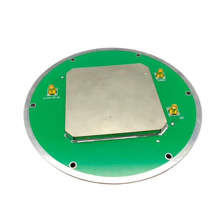
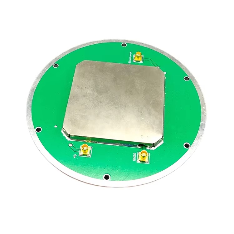
Lightweight and Compact Form Factor: Drones have strict payload limits, typically ranging from 200 grams to 5 kilograms depending on the model. RTK GNSS antennas for drones are therefore engineered to be lightweight (often 50–150 grams) and compact (diameters of 5–10 centimeters). This is achieved through the use of miniaturized components, such as thin-film radiating elements and low-profile enclosures, without sacrificing gain or phase stability.
Low-Profile, Aerodynamic Enclosure: To minimize wind resistance and avoid disrupting the drone’s flight dynamics, the antenna’s enclosure is designed with a streamlined, low-profile shape. The radome—usually made from lightweight materials like polycarbonate or ABS plastic—is contoured to reduce drag, ensuring that the drone maintains stability and battery efficiency during flight. Aerodynamic design is particularly critical for fixed-wing drones, which rely on smooth airflow for lift and maneuverability.
Dual-Frequency and Multi-Constellation Support: To maintain RTK accuracy in dynamic aerial environments, these antennas support multiple GNSS constellations (GPS, GLONASS, Galileo, BeiDou) and dual frequency bands (e.g., L1/L2, L1/L5). This multi-band capability allows the drone’s receiver to correct for ionospheric delays, which can fluctuate during flight as the drone changes altitude or moves across different atmospheric conditions. By accessing signals from multiple constellations, the antenna reduces the risk of signal loss due to temporary obstructions, such as trees or buildings.
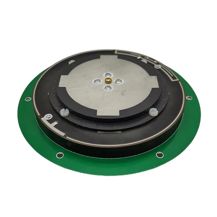
Highly Stable Phase Center: A stable phase center is essential for accurate positioning, especially as the drone tilts during turns or ascents. RTK GNSS drone antennas are calibrated to minimize phase center variation (PCV) across all angles, ensuring that measurements remain consistent regardless of the antenna’s orientation relative to the satellites. This stability is achieved through precise alignment of the radiating element and ground plane, often using computer-aided design (CAD) and automated manufacturing processes.
Construction Components
The physical construction of these antennas balances performance with the unique constraints of drone deployment:
Radiating Element: The core signal-receiving component is a miniaturized planar patch antenna, often made from copper or gold-plated copper, etched onto a low-loss ceramic or composite substrate. The patch is optimized for dual-frequency operation, with a design that ensures resonance at both L1 and L2 bands. Some advanced models use a multi-patch array to enhance gain while maintaining a compact footprint, leveraging constructive interference to boost signal strength without increasing size.
Integrated Low-Noise Amplifier (LNA): To amplify weak satellite signals while minimizing noise, the antenna includes a miniaturized LNA with a noise figure of <1 dB. The LNA is positioned directly behind the radiating element to reduce signal loss, and it is often powered via the drone’s flight controller through a coaxial cable, eliminating the need for a separate power source. This integration simplifies installation and reduces weight.
Shielded Ground Plane: A small, lightweight ground plane (typically aluminum or copper) is mounted beneath the radiating element to reflect signals and reduce interference from the drone’s electronics. The ground plane is often perforated or shaped to minimize weight while maintaining its shielding properties. In some designs, the ground plane is integrated into the antenna’s mounting bracket, which attaches to the drone’s frame via vibration-damping materials to reduce noise from the drone’s motors.
Flexible, Low-Loss Cable: The antenna is connected to the drone’s RTK receiver or flight controller via a thin, flexible coaxial cable (e.g., 0.8 mm diameter) with low signal attenuation. The cable is routed through the drone’s frame to avoid interference from motors or other electronics, and it is often reinforced with a braided shield to protect against electromagnetic interference (EMI).
Vibration and Shock Resistance: Drones generate vibrations from their motors, and they may experience shocks during takeoff, landing, or turbulence. RTK GNSS antennas for drones are therefore constructed with vibration-damping materials, such as silicone gaskets or foam padding, to protect internal components. The radiating element and LNA are securely bonded to the enclosure to prevent movement that could disrupt phase stability.
RTK GNSS antennas for drone-based surveying operate by combining high-precision signal reception with real-time correction data, adapted to the dynamic conditions of aerial flight:
Signal Capture During Dynamic Flight: As the drone moves, the antenna’s radiating element captures GNSS signals from multiple satellites. The multi-constellation, dual-frequency design ensures that signals are received even as the drone changes altitude, tilts, or moves through areas with partial obstructions (e.g., between buildings). The antenna’s stable phase center ensures that signal measurements remain consistent regardless of the drone’s orientation, a critical factor when calculating position during turns or ascents.
Amplification and Filtering: Weak signals are amplified by the integrated LNA, which boosts signal strength while adding minimal noise. The amplified signals pass through band-pass filters that isolate the desired GNSS frequencies, rejecting interference from the drone’s motors, cameras, or other onboard electronics. This filtering is essential in the crowded electromagnetic environment of a drone, where motors and sensors can generate EMI that would otherwise corrupt GNSS signals.
RTK Correction Reception: The drone’s RTK receiver processes the filtered signals and simultaneously receives correction data from a ground-based base station or a network RTK service (e.g., NTRIP). These corrections account for errors in satellite clocks, ionospheric delays, and tropospheric distortion. The antenna’s ability to maintain a strong signal lock ensures that the receiver can quickly apply these corrections, even during rapid drone movements.
Position Calculation and Data Logging: Using the corrected GNSS data, the receiver calculates the drone’s position with centimeter-level accuracy. This position data is timestamped and synchronized with the drone’s camera or LiDAR sensor data, ensuring that each captured image or point cloud is geotagged with precise coordinates. The synchronized data is logged to the drone’s onboard storage or transmitted in real time to a ground control station for immediate processing.
Dynamic Adaptation to Signal Conditions: Advanced RTK GNSS drone antennas include features like adaptive gain control, which adjusts amplification levels based on signal strength. For example, when the drone flies under a tree canopy, the antenna increases gain to capture weaker signals, then reduces gain when flying in open sky to avoid over-amplification. This adaptability ensures consistent performance across varying environments.
Advantages of RTK GNSS Antennas for Drone Surveying
These antennas offer transformative benefits that have made them essential for high-precision drone missions:
Centimeter-Level Accuracy in Aerial Mapping: The primary advantage is their ability to deliver horizontal accuracy of 1–3 cm and vertical accuracy of 2–5 cm, enabling the creation of highly detailed maps and models. This level of precision is critical for applications such as construction site progress monitoring, where even small deviations from design plans can indicate costly errors.
Reduced Dependence on Ground Control Points (GCPs): Traditional drone surveying requires placing GCPs—marked targets with known coordinates—across the survey area to georeference the data. RTK GNSS antennas eliminate or drastically reduce the need for GCPs, as the drone’s position is already precisely known. This saves significant time and labor, especially in large or remote areas where placing GCPs is logistically challenging.
Increased Efficiency and Coverage: Drones equipped with RTK antennas can cover larger areas in a single flight compared to traditional surveying methods. For example, a fixed-wing drone with an RTK antenna can survey 500+ acres in a 60-minute flight, collecting data that would take a ground team days to gather. This efficiency makes RTK drone surveying ideal for time-sensitive projects, such as post-disaster damage assessment.
Access to Hard-to-Reach Areas: Drones can fly over terrain that is dangerous or inaccessible to ground teams, such as steep slopes, flood zones, or active construction sites. RTK GNSS antennas ensure that data collected in these areas is still accurate, enabling surveyors to map previously unreachable locations without compromising on precision.
Real-Time Data Validation: Some RTK drone systems transmit positioning data to a ground control station in real time, allowing surveyors to validate data quality during the flight. If signal issues or accuracy problems are detected, the drone can be redirected to re-survey problematic areas immediately, reducing the need for costly re-flights.
Challenges and Limitations
Despite their advantages, RTK GNSS antennas for drone surveying face several challenges:
Signal Obstruction in Complex Environments: Drones flying in urban canyons, dense forests, or near tall structures may experience signal blockages, disrupting RTK corrections. While multi-constellation support helps, complete signal loss can still occur, leading to temporary drops in accuracy. In such cases, the drone may rely on inertial measurement units (IMUs) to estimate position, but this can introduce drift over time.
Weight and Payload Constraints: Smaller drones (e.g., consumer-grade quadcopters) have limited payload capacity, making it challenging to integrate high-performance RTK antennas alongside other sensors like LiDAR or high-resolution cameras. This can force trade-offs between accuracy and data quality, as heavier antennas may reduce flight time or require larger, more expensive drones.
Vibration and Noise Interference: Drone motors generate vibrations that can affect the antenna’s phase stability, introducing small positioning errors. Additionally, electronic noise from the drone’s flight controller, cameras, or batteries can interfere with GNSS signals, especially in compact drone designs where components are closely packed. Mitigating these issues requires careful antenna placement and shielding, adding complexity to drone integration.
Base Station Dependence: RTK accuracy relies on a nearby base station or access to a network RTK service. In remote areas without network coverage, users must deploy a portable base station, which adds equipment weight, cost, and setup time. While some systems use PPP (Precise Point Positioning) as a backup, PPP typically delivers decimeter-level accuracy, which may not meet project requirements.
Regulatory and Weather Limitations: Drone flights are subject to regulatory restrictions, such as altitude limits or no-fly zones, which can constrain surveying missions. Additionally, adverse weather—including heavy rain, fog, or high winds—can disrupt GNSS signals or ground drone operations entirely, delaying projects.
Applications
RTK GNSS antennas for drone-based surveying are deployed across industries that require high-precision aerial data:
Construction and Infrastructure Monitoring: Drones equipped with RTK antennas are used to survey construction sites, track progress, and compare as-built conditions with design plans. The centimeter-level accuracy enables early detection of deviations, such as misaligned foundations or incorrect grading, reducing rework costs. For example, a weekly drone survey of a highway construction site can generate 3D models that show how the project aligns with specifications, allowing managers to address issues promptly.
Agriculture and Precision Farming: In agriculture, RTK-enabled drones map crop health, soil variability, and irrigation patterns. Farmers use these maps to apply fertilizers, pesticides, or water with pinpoint precision, optimizing resource use and yields. The antennas ensure that field boundaries and crop rows are mapped accurately, even in large, irregularly shaped fields.
Mining and Quarrying: Mining operations use RTK drone surveys to measure stockpiles, monitor pit walls for stability, and track excavation progress. The high accuracy of RTK data allows for precise volume calculations of ore or waste, improving inventory management and compliance with environmental regulations. Drones can safely survey active mining areas, reducing the need for workers to enter hazardous zones.
Environmental Monitoring and Conservation: RTK-equipped drones map wetlands, forests, and coastal areas to monitor habitat changes, erosion, or pollution. For example, conservationists use drone surveys to track deforestation rates in tropical regions, with RTK accuracy ensuring that changes in tree cover are measured precisely over time. Drones also survey flood zones after natural disasters, providing emergency responders with detailed maps of affected areas.
Land Surveying and Cadastre: Land surveyors use RTK drones to create boundary maps, topographic surveys, and cadastral records. The technology reduces the time required to survey large parcels of land, especially in rural or remote areas, while delivering accuracy comparable to traditional ground surveys. This is particularly valuable for land disputes or property development projects, where precise boundary definitions are critical.
Future Trends
The evolution of RTK GNSS antennas for drone surveying is driven by advances in miniaturization, connectivity, and sensor integration:
Miniaturization and Integration: Future antennas will be even smaller and lighter, enabling integration with compact drones and reducing payload impact. Manufacturers are exploring new materials, such as flexible electronics and metamaterials, to create ultra-thin antennas that can be mounted on drone wings or bodies without disrupting aerodynamics.
AI-Powered Signal Optimization: Artificial intelligence (AI) algorithms will enhance antenna performance by predicting and mitigating signal obstructions. For example, AI could analyze terrain data to anticipate when the drone will fly into a signal shadow (e.g., behind a mountain) and adjust gain or switch constellations proactively to maintain accuracy.
Multi-Sensor Fusion: RTK GNSS antennas will increasingly work with complementary sensors, such as LiDAR, IMUs, and cameras, to create a unified positioning system. This fusion will compensate for GNSS signal loss by using LiDAR or visual odometry to estimate position, ensuring continuous high accuracy even in challenging environments.
5G and LEO Satellite Integration: 5G networks will enable faster transmission of RTK corrections, extending network RTK coverage to remote areas. Low Earth Orbit (LEO) satellite constellations (e.g., Starlink, Planet) will provide stronger, more reliable GNSS signals, reducing dependence on ground-based base stations and improving performance in polar regions or deep canyons.
Autonomous Drone Swarms: RTK GNSS antennas will support coordinated flights of multiple drones, or swarms, which can survey large areas more quickly than a single drone. Each drone in the swarm will use precise RTK positioning to maintain formation and avoid collisions, while synchronizing data collection for seamless mapping.
Conclusion
RTK GNSS antennas have transformed drone-based surveying by enabling centimeter-level accuracy in aerial mapping, a capability that has redefined efficiency and precision across industries. Their compact, lightweight design, combined with multi-constellation support and stable phase performance, addresses the unique challenges of drone flight, from payload constraints to dynamic signal conditions. By reducing reliance on ground control points and enabling real-time data validation, these antennas have made drone surveying a viable alternative to traditional methods, especially in remote or inaccessible areas.
While challenges such as signal obstruction, vibration interference, and base station dependence persist, ongoing advancements in miniaturization, AI, and sensor fusion are addressing these limitations. Future RTK GNSS antennas for drones will be smaller, smarter, and more integrated, further expanding their role in construction, agriculture, environmental monitoring, and beyond.
As drone technology continues to evolve, RTK GNSS antennas will remain a critical component, ensuring that aerial surveying missions deliver the high-precision data needed to drive informed decision-making. Their ability to bridge the gap between satellite signals and actionable geospatial insights will continue to unlock new possibilities in mapping, monitoring, and management of the world’s natural and built environments.

 86 0755 2819 9597
Lucy Yang | lucy.y@toxutech.com
Nicole Li | nicole@toxutech.com
Dotty Zhao | sales04@toxutech.com
Global Business Director / Sales Team / Global Operations


 En
En Cn
Cn Korean
 Home >


