

-
Products -PCBA Manufacturing RF Connectors RF Cable Assemblys Embedded Antennas External Antennas Positioning Chips and Modules
RF Connectors

RF Cable Assemblys
Embedded Antennas
External Antennas
Positioning Chips and Modules


 Language


Language


In the ever - evolving landscape of satellite positioning technology, the RTK (Real - Time Kinematic) Combination Antenna for Simultaneous GPS has become a game - changer. GPS (Global Positioning System), developed and maintained by the United States, has long been a cornerstone of positioning services, but its performance can be limited in scenarios requiring high precision and simultaneous signal processing. The RTK Combination Antenna for Simultaneous GPS addresses these limitations by integrating advanced antenna design with RTK technology, enabling not only the reception of multiple GPS signals simultaneously but also achieving centimeter - level positioning accuracy in real - time.
Simultaneous GPS signal reception is a critical requirement in many modern applications. Unlike traditional GPS antennas that may focus on a single frequency band or a limited set of satellite signals, this specialized RTK combination antenna is engineered to capture signals from multiple GPS satellites operating on different frequency bands—such as the widely used L1 (1575.42 MHz) band, the L2 (1227.60 MHz) band for more precise measurements, and the L5 (1176.45 MHz) band designed for enhanced reliability and accuracy—all at the same time. This simultaneous reception is essential for minimizing signal latency, improving positioning consistency, and reducing the impact of signal blockages or interference. For example, in dynamic applications like high - speed autonomous vehicles or precision agricultural machinery, the ability to process multiple GPS signals simultaneously ensures that the system can quickly adapt to changes in satellite visibility, maintaining accurate positioning even as the vehicle moves rapidly across varying terrains.
Moreover, the combination aspect of this antenna goes beyond just simultaneous GPS signal reception. It often involves the integration of multiple antenna elements, signal - processing modules, and compatibility with RTK correction data systems—all within a single, compact unit. This integration not only simplifies installation and reduces the overall footprint of the positioning system but also enhances the antenna's ability to work seamlessly with RTK technology. RTK systems rely on a base station and a rover (the device equipped with the antenna) to compare satellite signals and apply real - time corrections. The RTK Combination Antenna for Simultaneous GPS acts as the critical interface for the rover, capturing the necessary GPS signals and ensuring that they are of sufficient quality to support the RTK correction process.
In addition to its core functionality, this antenna is designed to operate in a wide range of environmental conditions. Whether deployed in harsh industrial settings, remote agricultural fields, or urban canyons with tall buildings, it must maintain consistent performance. This requires robust construction, advanced signal - filtering technologies, and resistance to factors such as extreme temperatures, moisture, electromagnetic interference (EMI), and physical vibration. For instance, in a construction site where heavy machinery generates significant EMI and dust levels are high, the antenna must filter out unwanted noise while remaining protected from physical damage.
The importance of the RTK Combination Antenna for Simultaneous GPS is further underscored by the growing demand for high - precision positioning across industries. From surveying and mapping to precision agriculture, autonomous transportation, and geospatial data collection, the need for real - time, centimeter - level accuracy is no longer a luxury but a necessity. Traditional GPS antennas, even with basic RTK support, often struggle to meet these demands in dynamic or challenging environments, making the specialized RTK Combination Antenna for Simultaneous GPS an indispensable tool.
To fully appreciate the value of this antenna, it is essential to understand its role in the broader GPS ecosystem. GPS satellites orbit the Earth in a constellation of 24 operational satellites (with additional spare satellites), each transmitting signals that contain information about the satellite's position and the time the signal was sent. A GPS receiver uses these signals to calculate its own position by measuring the time it takes for the signals to travel from the satellites to the receiver. However, this basic positioning method is prone to errors caused by factors such as atmospheric delays (ionospheric and tropospheric), satellite clock inaccuracies, and multipath interference (where signals bounce off objects like buildings or trees before reaching the receiver). RTK technology mitigates these errors by using a base station with a known position to calculate correction data, which is then transmitted to the rover. The rover uses this correction data to adjust its position calculations, significantly improving accuracy. The RTK Combination Antenna for Simultaneous GPS enhances this process by ensuring that the rover receives multiple GPS signals simultaneously, providing more data points for the correction algorithm and reducing the impact of individual signal errors.
In summary, the RTK Combination Antenna for Simultaneous GPS is a specialized, high - performance device that bridges the gap between basic GPS reception and advanced RTK - enabled precision. By enabling simultaneous reception of multiple GPS signals, integrating with RTK correction systems, and offering robust environmental performance, it meets the demands of modern applications requiring real - time, centimeter - level positioning accuracy. As industries continue to push the boundaries of what is possible with GPS technology, this antenna will remain a key enabler of innovation and progress.
The design and construction of the RTK Combination Antenna for Simultaneous GPS are meticulous processes, tailored to meet the unique requirements of simultaneous GPS signal reception and RTK - enabled precision. Every component, from the antenna elements to the housing and signal - processing modules, is engineered to work in harmony, ensuring optimal performance, reliability, and durability.
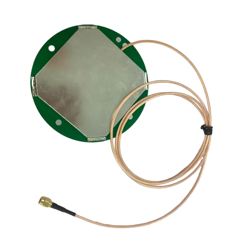
2.1 Antenna Elements: The Heart of Signal Reception
The antenna elements are the primary components responsible for capturing GPS signals, and their design is critical to enabling simultaneous reception of multiple GPS frequency bands. Unlike single - band GPS antennas, which use a single element tuned to a specific frequency (e.g., L1), the RTK Combination Antenna for Simultaneous GPS incorporates multiple specialized elements, each optimized for a different GPS band.
Ceramic patch antenna elements are the most commonly used type in these antennas, and for good reason. Ceramic materials offer high dielectric constant values, which allow for compact element designs without sacrificing performance. Each ceramic patch is precision - engineered to resonate at a specific GPS frequency—L1, L2, or L5. For example, the L1 patch is tuned to 1575.42 MHz, the L2 patch to 1227.60 MHz, and the L5 patch to 1176.45 MHz. The shape and size of each patch are carefully calculated using electromagnetic simulation software to ensure maximum signal absorption at the target frequency. Additionally, ceramic patches exhibit excellent circular polarization performance, which is essential for GPS signal reception. GPS satellites transmit circularly polarized signals, and a well - designed ceramic patch can efficiently convert these signals into electrical signals for processing, minimizing signal loss and interference.
In some advanced designs, especially those targeting high - performance applications like autonomous vehicles or precision surveying, helical antenna elements may be incorporated alongside ceramic patches. Helical antennas offer several advantages, including a wider beamwidth and better axial ratio (a measure of polarization purity) compared to ceramic patches. This wider beamwidth allows the antenna to capture signals from GPS satellites at lower elevations, which is particularly useful in urban canyons or mountainous areas where satellite visibility is limited. The improved axial ratio ensures that the antenna can maintain consistent signal reception even when the satellite's polarization varies slightly due to atmospheric effects.
To enable simultaneous reception, the antenna elements are arranged in a compact array within the antenna housing. The spacing between elements is carefully optimized to avoid mutual coupling—a phenomenon where the electromagnetic fields of one element interfere with those of another. Mutual coupling can degrade signal quality and reduce the antenna's ability to distinguish between different GPS signals. To mitigate this, engineers use electromagnetic modeling tools to simulate the interaction between elements and adjust their positions and orientations accordingly. In some cases, small metallic shields or isolation walls may be placed between elements to further reduce cross - talk.
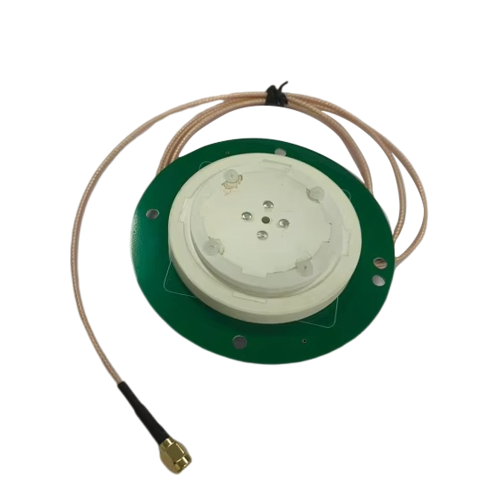
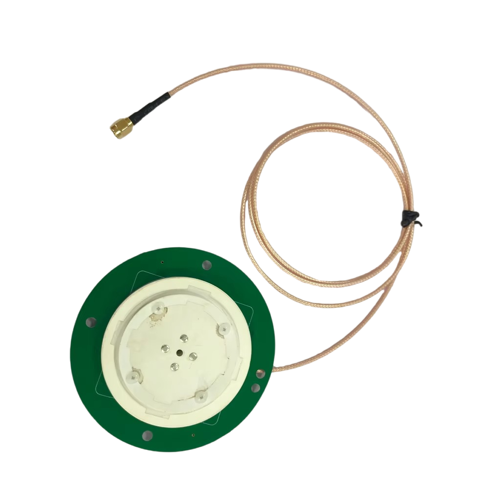
2.2 Housing: Protection and Performance Optimization
The housing of the RTK Combination Antenna for Simultaneous GPS serves two primary purposes: protecting the internal components from environmental damage and optimizing the antenna's electromagnetic performance. The design of the housing is therefore a balance between durability, environmental resistance, and signal transparency.
Material selection is a critical aspect of housing design. The outer shell is typically made from high - strength, weather - resistant materials such as fiberglass - reinforced plastic (FRP) or polycarbonate. These materials offer excellent resistance to extreme temperatures (ranging from -40°C to +85°C, or even wider ranges for specialized applications), moisture, UV radiation, and physical impact. FRP, in particular, is lightweight yet strong, making it ideal for applications where weight is a concern—such as UAVs (unmanned aerial vehicles) or portable surveying equipment. Additionally, these materials are non - conductive, which prevents them from interfering with the electromagnetic fields of the antenna elements.
To ensure environmental protection, the housing is often rated to IP (Ingress Protection) standards. A common rating for these antennas is IP67, which means the housing is dust - tight and can withstand immersion in water up to 1 meter for 30 minutes. For applications in harsher environments—such as offshore marine operations or heavy industrial settings—higher ratings like IP68 (which allows for longer immersion times or deeper depths) or IP69 (resistant to high - pressure, high - temperature water jets for cleaning) may be used. The sealing of the housing is also crucial; gaskets made from materials like silicone or EPDM (ethylene propylene diene monomer) rubber are used at all entry points (such as connector ports) to prevent water, dust, or debris from entering the internal components.
In addition to protection, the housing's shape and structure are designed to optimize the antenna's performance. The top of the housing, which is directly above the antenna elements, is often curved or dome - shaped. This design helps to minimize signal attenuation by ensuring that GPS signals can pass through the housing with minimal loss. The curvature also helps to reduce wind resistance, which is important for applications like UAVs or vehicles moving at high speeds. Inside the housing, a metallic ground plane is often placed beneath the antenna elements. The ground plane acts as a reflector, focusing the electromagnetic energy of the antenna elements upward toward the GPS satellites and reducing signal loss downward. The size and shape of the ground plane are carefully calculated to match the frequency bands of the antenna elements; a larger ground plane may be used for lower frequencies (like L2 or L5) to improve signal stability.
2.3 Signal - Processing Modules: Enhancing Signal Quality for RTK
The RTK Combination Antenna for Simultaneous GPS is not just a passive signal receiver; it also includes integrated signal - processing modules that prepare the captured GPS signals for use in RTK systems. These modules are critical to ensuring that the signals are of sufficient quality to support centimeter - level positioning accuracy.
The first stage of signal processing is amplification. GPS signals are extremely weak when they reach the Earth's surface—typically on the order of -130 dBm to -150 dBm. To make these signals usable, a low - noise amplifier (LNA) is integrated into the antenna. The LNA is designed to boost the signal strength while adding minimal noise. The noise figure (NF) of the LNA is a key performance ;a lower NF (typically between 0.5 dB and 1.5 dB for high - performance antennas) means that the amplifier adds less noise to the signal, preserving the signal - to - noise ratio (SNR). The LNA is placed as close to the antenna elements as possible to minimize signal loss before amplification—this is known as "front - end" amplification and is essential for maintaining signal quality.
After amplification, the signals pass through a series of filters to remove unwanted interference. GPS signals operate in a crowded electromagnetic spectrum, and interference from other wireless systems (such as cellular networks, Wi - Fi, or radio transmitters) can degrade performance. Band - pass filters (BPFs) are used to isolate the GPS frequency bands (L1, L2, L5) and reject signals outside of these bands. Each frequency band has its own dedicated BPF, which is designed to have a narrow passband that precisely matches the GPS signal bandwidth. For example, the L1 C/A (Coarse/Acquisition) code signal has a bandwidth of approximately 2 MHz, so the L1 BPF is tuned to pass signals between 1574.42 MHz and 1576.42 MHz while attenuating signals outside this range. In addition to BPFs, some antennas may include notch filters to target specific sources of interference—such as signals from nearby cellular towers operating on frequencies close to GPS bands.
Another important signal - processing component is the power divider or combiner. Since the antenna receives signals from multiple GPS bands simultaneously, the power divider splits the amplified and filtered signals into separate paths for each band. Each path is then sent to a dedicated output port or to an integrated receiver module. In some designs, a combiner may be used to merge signals from multiple elements (e.g., multiple L1 patches) to improve signal strength and diversity. This is particularly useful in environments where signal multipath is a problem, as combining signals from different elements can help to cancel out reflected signals.
The final stage of signal processing within the antenna is impedance matching. The antenna elements and signal - processing modules have specific impedance characteristics (typically 50 ohms for GPS systems), and impedance matching ensures that the signal is transmitted from the antenna to the receiver with minimal reflection and loss. Impedance matching is achieved using passive components such as inductors, capacitors, or transmission line stubs, which are integrated into the antenna's printed circuit board (PCB). The PCB is designed to be compact and lightweight, with traces that are carefully routed to minimize signal loss and interference.
In summary, the design and construction of the RTK Combination Antenna for Simultaneous GPS are focused on three key areas: optimizing signal reception through specialized antenna elements, protecting internal components with a durable and weather - resistant housing, and enhancing signal quality with integrated processing modules. Each component is engineered to work together seamlessly, ensuring that the antenna can reliably receive multiple GPS signals simultaneously and support the high - precision requirements of RTK systems.
The working principles of the RTK Combination Antenna for Simultaneous GPS are rooted in the integration of simultaneous GPS signal reception, advanced signal processing, and real - time kinematic (RTK) correction technology. To understand how this antenna operates, it is essential to break down the process into three key stages: simultaneous GPS signal capture, on - board signal processing, and integration with RTK systems to deliver centimeter - level positioning accuracy.
3.1 Simultaneous GPS Signal Capture: The First Step to Precision
The primary function of the RTK Combination Antenna for Simultaneous GPS is to capture signals from multiple GPS satellites operating on different frequency bands—L1, L2, and L5—at the same time. This simultaneous capture is made possible by the antenna's specialized element array, which includes dedicated elements for each frequency band.
GPS satellites transmit signals that travel through the Earth's atmosphere at the speed of light. When these signals reach the Earth's surface, they are extremely weak, so the antenna's elements are designed to be highly sensitive to their respective frequency bands. Each element (e.g., the L1 ceramic patch) resonates at its target frequency, converting the electromagnetic energy of the GPS signal into an electrical signal. Since the elements are arranged in an array with minimal mutual coupling, they can capture signals from multiple satellites on different bands without interfering with each other.
For example, consider a scenario where the antenna is deployed on a precision agricultural tractor. As the tractor moves through a field, the antenna's L1 elements capture signals from GPS satellites transmitting on the L1 band (used for basic positioning), the L2 elements capture signals on the L2 band (used for more precise measurements, especially in RTK systems), and the L5 elements capture signals on the L5 band (designed for enhanced reliability and resistance to interference). This simultaneous capture ensures that the antenna is not limited to a single source of positioning data; instead, it has access to a wealth of information from multiple bands, which is critical for improving accuracy and reducing the impact of signal errors.
The ability to capture multiple bands simultaneously also allows the antenna to take advantage of different signal characteristics. For instance, the L5 band has a wider bandwidth than L1, which makes it more resistant to multipath interference. The L2 band, on the other hand, is less affected by ionospheric delays (a major source of GPS positioning errors) because it operates at a lower frequency than L1. By combining data from all three bands, the antenna can cross - validate signals and reduce the impact of individual errors, laying the foundation for high - precision positioning.
Another key aspect of simultaneous signal capture is the antenna's beamwidth and gain pattern. The antenna elements are designed to have a wide beamwidth, typically between 90° and 120°, which allows them to capture signals from GPS satellites at various elevations—from low - elevation satellites near the horizon to high - elevation satellites directly overhead. This is important because low - elevation satellites are often more affected by atmospheric delays and multipath, but they can also provide additional positioning data in areas where high - elevation satellites are blocked (e.g., urban canyons). The antenna's gain pattern is optimized to provide consistent signal strength across its beamwidth, ensuring that signals from all visible satellites are captured with minimal loss.
3.2 On - Board Signal Processing: Cleaning and Preparing the Signal
Once the GPS signals are captured by the antenna elements, they undergo a series of on - board processing steps to clean the signal, reduce interference, and prepare it for transmission to the RTK receiver. This processing is critical because raw GPS signals are often contaminated by noise, interference, and atmospheric effects, which can degrade the accuracy of the positioning calculation.
The first step in signal processing is amplification by the low - noise amplifier (LNA). As mentioned earlier, GPS signals are extremely weak when they reach the antenna, so the LNA boosts the signal strength by 20 dB to 40 dB while adding minimal noise. The LNA's low noise figure (NF) is essential here—even a small increase in noise can reduce the signal - to - noise ratio (SNR), making it harder for the receiver to decode the GPS signal. For example, an LNA with a NF of 1 dB will add only a small amount of noise to the signal, preserving the integrity of the data contained within the GPS signal.
After amplification, the signals pass through band - pass filters (BPFs) for each frequency band. The BPFs are designed to isolate the GPS signals from unwanted interference. For instance, the L1 BPF will filter out signals from cellular networks operating on frequencies close to 1575.42 MHz (such as some 4G LTE bands around 1500 MHz or 1700 MHz) and Wi-Fi signals at 2.4 GHz or 5 GHz. This filtering is critical because even a small amount of interference can cause the receiver to misinterpret the GPS signal, leading to positioning errors. The BPFs are designed with a high out-of-band rejection ratio—typically 40 dB or more—which means they can attenuate unwanted signals by a factor of 10,000 or more, ensuring that only the desired GPS signals pass through to the next stage of processing.
Following filtering, the signals are split into separate paths for each frequency band using a power divider. The power divider is a passive component that evenly distributes the signal energy without introducing significant loss or noise. For example, a three-way power divider would split the amplified and filtered signal into three paths: one for L1, one for L2, and one for L5. Each path is then routed to a dedicated output port, where it can be connected to an RTK receiver via a coaxial cable. In some integrated designs, the antenna may include a built-in receiver module that directly processes the signals from each band, eliminating the need for external cables and reducing signal loss.
Impedance matching is the final step in on-board signal processing. The antenna elements and signal-processing modules have an impedance of 50 ohms, which is the standard impedance for GPS systems. If the impedance of the antenna does not match the impedance of the receiver or the coaxial cable, a portion of the signal will be reflected back, leading to signal loss and reduced performance. To avoid this, impedance-matching networks are integrated into the antenna's PCB. These networks use a combination of inductors, capacitors, and transmission line stubs to adjust the impedance of the antenna to 50 ohms. For example, a matching network for the L1 band might use a series capacitor and a shunt inductor to cancel out any reactive components in the antenna element, ensuring that the impedance is purely resistive and matches the receiver.
3.3 Integration with RTK Systems: Delivering Centimeter-Level Accuracy
The true value of the RTK Combination Antenna for Simultaneous GPS becomes apparent when it is integrated with an RTK system. RTK technology relies on a two-part system: a base station and a rover. The base station is a fixed receiver with a known position, while the rover is a mobile receiver equipped with the RTK combination antenna. Together, these two components work to calculate and apply real-time corrections to the GPS positioning data, achieving centimeter-level accuracy.
The process begins with the base station. The base station receives GPS signals from the same satellites as the rover and uses its known position to calculate the difference between the measured position (based on the GPS signals) and its actual position. This difference is known as the "error vector," and it includes contributions from atmospheric delays, satellite clock inaccuracies, and other sources of error. The base station then transmits this error vector to the rover as RTK correction data. This data is typically transmitted via a wireless link, such as a UHF radio, cellular network, or satellite communication system.
The rover, equipped with the RTK Combination Antenna for Simultaneous GPS, receives both the GPS signals from the satellites and the RTK correction data from the base station. The antenna's ability to receive multiple GPS signals simultaneously is critical here because it provides the rover with a wealth of data points to compare with the correction data. For example, if the rover is receiving signals from 8 GPS satellites (2 on L1, 3 on L2, and 3 on L5), it can use the correction data to adjust each of these signals individually, reducing the impact of errors on each frequency band.
Once the rover has received the GPS signals and the correction data, it performs a process known as "carrier-phase tracking." GPS signals consist of two main components: a carrier wave (a high-frequency sinusoidal signal) and a code (a digital sequence used to identify the satellite and calculate the time of flight). In traditional GPS positioning, the code is used to measure the time of flight, but this method is limited to meter-level accuracy. In RTK positioning, the carrier wave is used instead. The carrier wave has a much higher frequency than the code (e.g., 1575.42 MHz for L1), which allows for much more precise measurements of the time of flight.
The rover compares the carrier-phase measurements from its own antenna with the carrier-phase measurements from the base station (included in the correction data). By calculating the difference between these measurements, the rover can eliminate the common errors that affect both the base station and the rover—such as atmospheric delays and satellite clock inaccuracies. This process is known as "differential positioning," and it is what enables RTK systems to achieve centimeter-level accuracy.
The RTK Combination Antenna for Simultaneous GPS enhances this process in several ways. First, by receiving signals from multiple GPS bands simultaneously, the rover has more carrier-phase measurements to work with. This increases the redundancy of the data, making the positioning calculation more robust and less susceptible to errors from individual satellites or frequency bands. For example, if the L1 signal from one satellite is corrupted by multipath interference, the rover can rely on the L2 or L5 signals from the same satellite to maintain accurate positioning.
Second, the antenna's advanced signal-processing modules ensure that the carrier-phase measurements are of high quality. The low-noise amplifier (LNA) and band-pass filters (BPFs) reduce noise and interference, making it easier for the rover to track the carrier wave accurately. This is particularly important in dynamic applications, such as high-speed autonomous vehicles, where the rover is moving rapidly and the carrier-phase measurements must be updated frequently to maintain accuracy.
Finally, the antenna's stable phase center is critical for RTK positioning. The phase center is the point from which the antenna appears to radiate or receive signals, and any variation in the phase center can introduce errors in the carrier-phase measurements. The RTK Combination Antenna for Simultaneous GPS is designed with a highly stable phase center, typically with variations of less than 1 mm across all frequency bands. This ensures that the carrier-phase measurements from the antenna are consistent and accurate, even as the rover moves or the satellite positions change.
In summary, the working principles of the RTK Combination Antenna for Simultaneous GPS involve three key stages: simultaneous capture of GPS signals from multiple frequency bands, on-board processing to clean and prepare the signals, and integration with an RTK system to apply real-time corrections and achieve centimeter-level accuracy. Each stage is designed to work in harmony with the others, ensuring that the antenna delivers reliable, high-precision positioning in a wide range of applications.
The RTK Combination Antenna for Simultaneous GPS offers a range of advantages that make it a preferred choice for high-precision positioning applications, but it also faces several challenges that must be addressed to fully realize its potential. Understanding these advantages and challenges is essential for engineers, researchers, and end-users who are considering deploying this technology.
4.1 Advantages: Why Choose the RTK Combination Antenna for Simultaneous GPS
4.1.1 Centimeter-Level Positioning Accuracy
The most significant advantage of the RTK Combination Antenna for Simultaneous GPS is its ability to achieve centimeter-level positioning accuracy in real-time. This level of accuracy is far superior to that of traditional GPS antennas, which typically offer meter-level accuracy. The key to this high accuracy lies in the antenna's ability to receive multiple GPS signals simultaneously and integrate with RTK technology. By capturing signals from L1, L2, and L5 bands, the antenna provides the rover with more data points to compare with the RTK correction data, reducing the impact of errors and enabling precise carrier-phase tracking.
This level of accuracy is transformative for many industries. In surveying and mapping, for example, centimeter-level accuracy allows surveyors to create detailed topographic maps, mark property boundaries, and align infrastructure projects with minimal error. In precision agriculture, it enables farmers to apply fertilizers, pesticides, and seeds with pinpoint accuracy, reducing waste and improving crop yields. In autonomous transportation, it ensures that self-driving cars, trucks, and drones can navigate safely and precisely, even in complex environments.
4.1.2 Enhanced Signal Reliability and Availability
Another major advantage of the RTK Combination Antenna for Simultaneous GPS is its enhanced signal reliability and availability. Traditional GPS antennas that rely on a single frequency band are often susceptible to signal blockages, interference, and multipath effects. For example, in urban canyons, tall buildings can block signals from high-elevation satellites, leaving the antenna with only low-elevation satellites that are more affected by atmospheric delays. In rural areas, interference from nearby radio transmitters or power lines can degrade the signal quality.
The RTK Combination Antenna for Simultaneous GPS addresses these issues by receiving signals from multiple frequency bands. If one band is blocked or corrupted by interference, the antenna can rely on signals from other bands to maintain positioning. For example, if the L1 band is affected by multipath interference in an urban environment, the L5 band—with its wider bandwidth and better resistance to multipath—can provide a reliable signal. Additionally, the antenna's wide beamwidth allows it to capture signals from satellites at various elevations, increasing the number of visible satellites and improving signal availability.
This enhanced reliability is critical for applications that require continuous positioning. In emergency services, for example, first responders rely on GPS to navigate to accident scenes quickly and safely. A reliable GPS signal can mean the difference between life and death in these situations. In industrial settings, such as mining or construction, continuous positioning is essential for monitoring the movement of heavy machinery and ensuring worker safety.
4.1.3 Compact and Integrated Design
The RTK Combination Antenna for Simultaneous GPS is designed to be compact and integrated, which offers several benefits for end-users. Unlike traditional systems that require multiple antennas (one for each frequency band) and external signal-processing equipment, this antenna combines all necessary components—multiple antenna elements, LNAs, BPFs, and power dividers—into a single, lightweight unit. This reduces the overall footprint of the positioning system, making it easier to install and deploy in space-constrained applications.
For example, in UAVs, weight and space are critical factors. A compact RTK combination antenna can be mounted on the UAV without adding excessive weight or interfering with the vehicle's aerodynamics. In portable surveying equipment, a small antenna makes the device easier to carry and use in remote areas. The integrated design also simplifies installation, as end-users do not need to align multiple antennas or connect multiple cables. This reduces the risk of installation errors and saves time and labor costs.
4.1.4 Robust Environmental Performance
The RTK Combination Antenna for Simultaneous GPS is engineered to operate in a wide range of environmental conditions, making it suitable for use in harsh and demanding applications. The antenna's housing is made from high-strength materials like FRP or polycarbonate, which are resistant to extreme temperatures, moisture, UV radiation, and physical impact. The IP67, IP68, or IP69 rating ensures that the antenna is protected from dust, water, and other contaminants.
This robust performance is essential for applications in outdoor or industrial environments. In offshore marine operations, for example, the antenna must withstand saltwater corrosion, high winds, and heavy rain. In mining, it must resist dust, vibration, and extreme temperatures. In construction, it must handle the impact of heavy machinery and the wear and tear of daily use. The antenna's ability to maintain performance in these conditions ensures that the positioning system remains reliable and accurate, even in the most challenging environments.
4.2 Challenges: Overcoming Barriers to Adoption
4.2.1 High Cost
One of the main challenges facing the RTK Combination Antenna for Simultaneous GPS is its high cost. The specialized components used in the antenna—such as high-performance ceramic patch elements, low-noise amplifiers, and precision filters—are expensive to manufacture. Additionally, the engineering and testing required to ensure that the antenna can receive multiple signals simultaneously and integrate with RTK systems adds to the cost.
This high cost can be a barrier to adoption for small businesses or applications with tight budgets. For example, a small-scale farmer may not be able to afford an RTK combination antenna for their tractor, even though it would improve crop yields and reduce waste. A startup developing a low-cost drone may choose to use a traditional GPS antenna instead, sacrificing accuracy for affordability.
To address this challenge, manufacturers are working to reduce the cost of components and streamline the manufacturing process. For example, advances in ceramic material technology have made it possible to produce ceramic patch elements at a lower cost. The use of integrated circuits (ICs) for signal processing has also reduced the size and cost of the LNAs and BPFs. As these technologies continue to advance, the cost of the RTK Combination Antenna for Simultaneous GPS is expected to decrease, making it more accessible to a wider range of users.
4.2.2 Vulnerability to Electromagnetic Interference (EMI)
Despite its advanced filtering capabilities, the RTK Combination Antenna for Simultaneous GPS is still vulnerable to electromagnetic interference (EMI) from other wireless systems. The GPS frequency bands are located in a crowded part of the electromagnetic spectrum, and interference from cellular networks, Wi-Fi, radio transmitters, and other electronic devices can degrade the signal quality.
For example, 5G cellular networks operate on frequencies close to the GPS L5 band (1176.45 MHz), and strong 5G signals can cause interference with the L5 GPS signals. In industrial settings, heavy machinery such as electric motors, welding equipment, and power inverters can generate EMI that affects the antenna's performance. This interference can lead to positioning errors, signal dropouts, and reduced accuracy.
To mitigate this challenge, engineers are developing more advanced filtering techniques. For example, adaptive filters that can adjust their frequency response in real-time to reject interference are being integrated into the antenna's signal-processing modules. Additionally, the use of shielding materials—such as conductive coatings or metallic enclosures—can help to block EMI from external sources. Researchers are also exploring the use of machine learning algorithms to identify and filter out interference patterns, further improving the antenna's resistance to EMI.
4.2.3 Multipath Interference
Multipath interference remains a persistent challenge for the RTK Combination Antenna for Simultaneous GPS. Multipath occurs when GPS signals bounce off objects such as buildings, trees, water, or the ground before reaching the antenna. These reflected signals arrive at the antenna at a slightly different time than the direct signals, causing the receiver to misinterpret the time of flight and leading to positioning errors.
While the antenna's use of multiple frequency bands (especially L5) and circular polarization helps to reduce multipath, it does not eliminate it entirely. In complex environments such as urban canyons, dense forests, or busy ports, multipath can still be a significant problem. For example, in a city with tall buildings, GPS signals can bounce off the sides of buildings multiple times before reaching the antenna, creating a series of reflected signals that interfere with the direct signal.
To address this challenge, researchers are developing new antenna designs and signal-processing algorithms. For example, array antennas with multiple elements can be used to beamform the antenna's gain pattern, focusing on direct signals and rejecting reflected signals. Machine learning algorithms can also be trained to recognize the characteristics of multipath signals and subtract them from the received data. Additionally, the use of inertial measurement units (IMUs) in combination with the GPS antenna can help to compensate for multipath errors by providing alternative positioning data when the GPS signal is corrupted.
4.2.4 Dependence on RTK Base Stations
The RTK Combination Antenna for Simultaneous GPS relies on RTK base stations to provide correction data, which can be a limitation in some applications. Base stations are fixed receivers with a known position, and they must be deployed in areas with good satellite visibility. In remote or sparsely populated areas, the availability of base stations may be limited, making it difficult to use RTK technology.
For example, in a remote mining operation in the Australian outback, there may be no nearby base stations, requiring the operator to deploy their own. This adds to the cost and complexity of the positioning system, as the base station must be installed, calibrated, and maintained. Additionally, the wireless link between the base station and the rover can be affected by distance, terrain, and interference, leading to delays or dropouts in the correction data.
To overcome this challenge, new approaches to RTK positioning are being developed. One such approach is network RTK, which uses a network of base stations to provide correction data over a large area. Network RTK eliminates the need for a dedicated base station for each rover, reducing cost and complexity. Another approach is precise point positioning (PPP), which uses a single receiver and correction data from a global network of base stations to achieve centimeter-level accuracy. While PPP is not as fast as RTK, it does not require a local base station, making it suitable for remote applications.
In summary, the RTK Combination Antenna for Simultaneous GPS offers significant advantages in terms of accuracy, reliability, design, and environmental performance, but it also faces challenges related to cost, EMI, multipath, and base station dependence. By addressing these challenges through technological innovation and cost reduction, the antenna has the potential to become an even more valuable tool for high-precision positioning applications.
The RTK Combination Antenna for Simultaneous GPS has a wide range of applications across various industries, thanks to its high-precision positioning capabilities, reliable signal reception, and robust design. As technology continues to advance, new applications are emerging, and future trends are shaping the development of this antenna. This section explores the current applications of the antenna and the key trends that will drive its evolution in the coming years.
5.1 Current Applications: Transforming Industries with High-Precision Positioning
5.1.1 Surveying and Mapping
Surveying and mapping is one of the oldest and most established applications of the RTK Combination Antenna for Simultaneous GPS. Surveyors rely on high-precision positioning to create detailed topographic maps, mark property boundaries, and align infrastructure projects such as roads, bridges, and buildings. The centimeter-level accuracy of the RTK combination antenna allows surveyors to collect data quickly and efficiently, reducing the time and labor required for traditional surveying methods.
For example, in the construction of a new highway, surveyors use the antenna to mark the alignment of the highway corridor with centimeter-level precision. This ensures that the road is built according to the design plans, minimizing the risk of costly rework. In topographic mapping, surveyors use the antenna to collect elevation data across large areas. By walking or driving with a rover equipped with the antenna, they can record thousands of data points per hour, which are then used to create 3D maps of the terrain. This is particularly useful for environmental monitoring, where changes in the landscape—such as erosion or deforestation—can be tracked over time with high accuracy.
Another key application in surveying is cadastral surveying, which involves defining and marking property boundaries. The RTK Combination Antenna for Simultaneous GPS allows surveyors to determine the exact location of boundary markers, reducing disputes between property owners. In urban areas, where space is limited and property values are high, this level of accuracy is essential for ensuring that buildings and other structures are constructed within the correct property lines.
5.1.2 Precision Agriculture
Precision agriculture is a rapidly growing application of the RTK Combination Antenna for Simultaneous GPS, as farmers seek to improve crop yields, reduce costs, and minimize environmental impact. The antenna is used in a variety of agricultural machinery, including tractors, harvesters, and sprayers, to enable precise positioning and navigation.
One of the most common uses of the antenna in precision agriculture is for "variable-rate application" (VRA). VRA involves applying fertilizers, pesticides, and seeds at different rates across a field based on the specific needs of each area. For example, a farmer may use soil sensors to determine the nutrient levels in different parts of the field. The RTK combination antenna provides the precise positioning data needed to map these nutrient levels and control the application rate of the machinery. This ensures that areas with low nutrient levels receive more fertilizer, while areas with high nutrient levels receive less, reducing waste and improving crop yields.
The antenna is also used for "autonomous steering" of agricultural machinery. Autonomous steering systems use the GPS positioning data from the antenna to guide the tractor or harvester along a pre-defined path with centimeter-level accuracy. This eliminates the need for the farmer to manually steer the machinery, reducing operator fatigue and improving efficiency. For example, a farmer can program a path for a tractor to plow a field, and the autonomous steering system will ensure that the tractor stays on course, even when the field is uneven or has obstacles.
In addition, the RTK Combination Antenna for Simultaneous GPS is used for crop scouting and yield mapping. Farmers can use a UAV equipped with the antenna to capture high-resolution images of the field. The GPS data from the antenna is used to geotag these images, allowing the farmer to identify areas of the field that are underperforming. Yield mapping involves using the antenna to track the position of a harvester as it collects crops. The harvester's yield monitor records the amount of crop harvested at each position, and the GPS data from the antenna is used to create a map of the yield across the field. This information can be used to identify factors that affect yield, such as soil quality or irrigation issues.
5.1.3 Autonomous Transportation
Autonomous transportation—including self-driving cars, trucks, buses, and drones—is one of the most exciting and rapidly evolving applications of the RTK Combination Antenna for Simultaneous GPS. The high-precision positioning provided by the antenna is essential for the safe and reliable operation of autonomous vehicles, as it allows them to navigate through complex environments and avoid obstacles.
In self-driving cars, the RTK Combination Antenna for Simultaneous GPS is used in conjunction with other sensors—such as cameras, lidar, and radar—to provide a comprehensive view of the vehicle's surroundings. The GPS data from the antenna is used to determine the vehicle's position on the road with centimeter-level accuracy, which is critical for tasks such as lane keeping, merging, and navigating intersections. For example, when a self-driving car approaches an intersection, the GPS data from the antenna is used to confirm the vehicle's position relative to the stop line and other vehicles, ensuring that the car stops or proceeds safely.
The antenna is also used in autonomous trucks for long-haul transportation. Autonomous trucks rely on high-precision positioning to navigate along highways and deliver goods to their destinations. The RTK combination antenna provides the positioning data needed to keep the truck in its lane, maintain a safe distance from other vehicles, and exit the highway at the correct ramp. In addition, the antenna's ability to receive multiple GPS signals simultaneously ensures that the truck maintains accurate positioning even in areas with poor satellite visibility, such as tunnels or urban canyons.
Drones, or unmanned aerial vehicles (UAVs), are another important application of the RTK Combination Antenna for Simultaneous GPS. Drones are used for a wide range of tasks, including aerial photography, mapping, inspection, and delivery. The high-precision positioning provided by the antenna allows drones to hover in place, fly along pre-defined paths, and land accurately. For example, a drone used for inspecting power lines can use the antenna to position itself precisely next to the power line, allowing the operator to capture detailed images of the line's condition. In delivery applications, the antenna ensures that the drone can land safely at the delivery location, even in areas with obstacles or changing weather conditions.
5.1.4 Marine and Offshore Operations
The RTK Combination Antenna for Simultaneous GPS is widely used in marine and offshore operations, where accurate positioning is essential for safety, efficiency, and compliance with regulations. Marine applications include navigation of ships, offshore oil and gas exploration, and hydrographic surveying.
In ship navigation, the antenna provides the precise positioning data needed to ensure that ships stay on course and avoid collisions with other vessels, reefs, or other hazards. The centimeter-level accuracy of the antenna is particularly important in narrow waterways, such as canals or harbors, where there is little room for error. For example, a large container ship navigating through the Panama Canal relies on the RTK combination antenna to maintain its position in the center of the canal, avoiding damage to the ship or the canal walls.
Offshore oil and gas exploration and production also rely heavily on the RTK Combination Antenna for Simultaneous GPS. The antenna is used to position drilling rigs, production platforms, and support vessels with high accuracy. For example, when a drilling rig is being moved to a new location, the antenna provides the positioning data needed to ensure that the rig is placed exactly over the wellhead. This is critical for the safety and efficiency of the drilling operation, as even a small deviation from the correct position can lead to costly delays or accidents.
Hydrographic surveying is another important marine application of the antenna. Hydrographic surveyors use the antenna to map the depth and shape of the seabed, which is essential for safe navigation, coastal engineering, and environmental monitoring. The antenna's ability to receive multiple GPS signals simultaneously ensures that the survey data is accurate even in areas with poor satellite visibility, such as near coastlines or in shallow water.
5.2 Future Trends: Shaping the Next Generation of RTK Combination Antennas
5.2.1 Integration with Multi-Constellation GNSS
While the RTK Combination Antenna for Simultaneous GPS currently focuses on GPS signals, a key future trend is the integration of multi-constellation Global Navigation Satellite Systems (GNSS). In addition to GPS, other major GNSS constellations include GLONASS (Russia), Galileo (European Union), and BeiDou (China). By integrating support for these constellations, the antenna will be able to receive signals from more satellites, improving signal availability, reliability, and accuracy.
For example, in an urban environment where GPS signals are blocked by tall buildings, the antenna may still be able to receive signals from GLONASS or BeiDou satellites, ensuring that the positioning system remains operational. Multi-constellation support also reduces the impact of satellite outages or maintenance, as the antenna can rely on signals from other constellations. In addition, combining data from multiple constellations allows for more precise carrier-phase tracking, further improving the antenna's accuracy.
Manufacturers are already beginning to develop RTK combination antennas that support multi-constellation GNSS, and this trend is expected to accelerate in the coming years. As more countries deploy and expand their GNSS constellations, the demand for multi-constellation antennas will grow, making them the standard for high-precision positioning applications.
5.2.2 Miniaturization and Low-Power Design
Another important future trend is the miniaturization and low-power design of the RTK Combination Antenna for Simultaneous GPS. As the antenna is used in smaller and more portable devices—such as wearable technology, small UAVs, and IoT (Internet of Things) sensors—there is a growing need for antennas that are smaller, lighter, and consume less power.
Advances in materials science and manufacturing technology are enabling the development of smaller antenna elements. For example, new ceramic materials with higher dielectric constants allow for the production of ceramic patch elements that are smaller in size but still maintain high performance. In addition, the integration of signal-processing components into a single chip—known as a "system-on-chip" (SoC)—is reducing the size and power consumption of the antenna's electronics.
Low-power design is also critical for battery-powered devices. For example, a wearable device used for outdoor navigation relies on a small battery, so the antenna must consume minimal power to extend the device's battery life. Manufacturers are developing low-power LNAs and BPFs that use less energy while still providing high performance. In addition, power management techniques—such as turning off unused components when the antenna is not in use—are being implemented to further reduce power consumption.
5.2.3 Artificial Intelligence (AI) and Machine Learning (ML) Integration
The integration of artificial intelligence (AI) and machine learning (ML) algorithms is a promising future trend for the RTK Combination Antenna for Simultaneous GPS. AI and ML can be used to improve the antenna's performance in several ways, including interference mitigation, multipath reduction, and signal prediction.
One of the key applications of AI/ML is in interference mitigation. ML algorithms can be trained to recognize the characteristics of different types of interference—such as 5G signals or industrial EMI—and adjust the antenna's filtering parameters in real-time to reject the interference. This adaptive filtering approach is more effective than traditional fixed filters, as it can handle a wider range of interference sources and adapt to changing environmental conditions.
AI/ML can also be used to reduce multipath interference. ML algorithms can be trained on large datasets of GPS signals, including both direct and multipath signals. By analyzing the patterns of these signals, the algorithms can learn to distinguish between direct and multipath signals and subtract the multipath component from the received data. This can significantly improve the accuracy of the antenna in complex environments such as urban canyons or dense forests.
In addition, AI/ML can be used for signal prediction. The algorithms can analyze historical GPS signal data to predict future signal conditions, such as satellite visibility or interference levels. This allows the antenna to proactively adjust its parameters—such as the gain of the LNA or the frequency of the BPF—to maintain optimal performance. For example, if the algorithm predicts that a satellite will move out of view, the antenna can switch to a different satellite or adjust its beamwidth to capture signals from other satellites.
5.2.4 Enhanced Security Features
As the RTK Combination Antenna for Simultaneous GPS is used in critical applications such as autonomous transportation, emergency services, and national security, there is a growing need for enhanced security features to protect against cyberattacks and signal spoofing. Signal spoofing involves transmitting fake GPS signals to the antenna, causing the receiver to calculate an incorrect position. This can have serious consequences, such as causing a self-driving car to navigate into a dangerous area or a drone to be hijacked.
To address this threat, future RTK combination antennas will include enhanced security features such as anti-spoofing algorithms and encryption. Anti-spoofing algorithms can detect fake GPS signals by analyzing their characteristics—such as signal strength, frequency, and time of arrival—and comparing them to expected values. If a fake signal is detected, the antenna can reject it and rely on other signals. Encryption can be used to secure the transmission of RTK correction data between the base station and the rover. By encrypting the correction data, it is more difficult for attackers to tamper with or spoof the data, ensuring that the rover receives accurate correction information.
In addition, manufacturers are exploring the use of blockchain technology to enhance the security of RTK systems. Blockchain can be used to create a tamper-proof record of the RTK correction data, ensuring that the data has not been altered. This can provide an additional layer of security for critical applications where the integrity of the positioning data is essential.
Conclusion
The RTK Combination Antenna for Simultaneous GPS has emerged as a critical technology for high-precision positioning applications across a wide range of industries. Its ability to receive multiple GPS signals simultaneously, integrate with RTK systems to achieve centimeter-level accuracy, and operate in harsh environmental conditions has transformed the way surveyors, farmers, transportation companies, and marine operators conduct their work.
Throughout this discussion, we have explored the key aspects of this antenna, including its overview, design and construction, working principles, advantages and challenges, applications, and future trends. The overview highlighted the antenna's role in addressing the limitations of traditional GPS antennas by enabling simultaneous signal reception and RTK integration. The design and construction section detailed the specialized components—such as ceramic patch elements, LNAs, BPFs, and robust housing—that make the antenna's performance possible. The working principles explained how the antenna captures, processes, and integrates GPS signals with RTK correction data to deliver high-precision positioning.
The advantages of the RTK Combination Antenna for Simultaneous GPS are clear: centimeter-level accuracy, enhanced signal reliability and availability, compact and integrated design, and robust environmental performance. These advantages have made it a preferred choice for applications where precision and reliability are essential. However, the antenna also faces challenges, including high cost, vulnerability to EMI and multipath interference, and dependence on RTK base stations. Manufacturers and researchers are actively working to address these challenges through technological innovation, such as cost reduction, advanced filtering techniques, and the development of network RTK and PPP systems.
The current applications of the antenna are diverse and growing, ranging from surveying and mapping to precision agriculture, autonomous transportation, and marine operations. Each application leverages the antenna's high-precision positioning capabilities to improve efficiency, reduce costs, and enhance safety. Looking to the future, the antenna is poised to evolve further, with trends such as multi-constellation GNSS integration, miniaturization and low-power design, AI/ML integration, and enhanced security features expected to drive its development.
As technology continues to advance, the RTK Combination Antenna for Simultaneous GPS will play an increasingly important role in enabling new and innovative applications. For example, the integration of multi-constellation GNSS will expand the antenna's usability in challenging environments, while AI/ML integration will further improve its performance and adaptability. The miniaturization of the antenna will allow it to be used in smaller and more portable devices, opening up new possibilities in wearable technology and IoT.
In conclusion, the RTK Combination Antenna for Simultaneous GPS is a technology that has already made a significant impact on various industries, and its potential for future growth and innovation is vast. By addressing the current challenges and embracing emerging trends, this antenna will continue to be a key enabler of high-precision positioning, driving progress and efficiency in the years to come. Whether it is helping farmers grow more food with less waste, enabling self-driving cars to navigate safely, or allowing surveyors to map the world with unprecedented accuracy, the RTK Combination Antenna for Simultaneous GPS is a technology that is shaping the future of positioning and navigation.

 86 0755 2819 9597
Lucy Yang | lucy.y@toxutech.com
Nicole Li | nicole@toxutech.com
Dotty Zhao | sales04@toxutech.com
Global Business Director / Sales Team / Global Operations


 En
En Cn
Cn Korean
 Home >


