

-
Products -PCBA Manufacturing RF Connectors RF Cable Assemblys Embedded Antennas External Antennas Positioning Chips and Modules
RF Connectors

RF Cable Assemblys
Embedded Antennas
External Antennas
Positioning Chips and Modules


 Language


Language


In the pursuit of ultimate precision in geospatial surveying, multi-constellation precision surveying Global Navigation Satellite System (GNSS) antennas have emerged as a transformative technology. Unlike single-constellation antennas that rely solely on one satellite network (such as GPS), these advanced antennas are engineered to simultaneously receive signals from multiple GNSS constellations—including GPS (United States), GLONASS (Russia), Galileo (European Union), BeiDou (China), and regional systems like QZSS (Japan) and NavIC (India). This multi-constellation capability is a game-changer for precision surveying, as it unlocks higher accuracy, improved reliability, and enhanced performance in challenging environments where satellite visibility is limited.
Precision surveying demands sub-meter to centimeter-level accuracy, a requirement that single-constellation antennas often struggle to meet consistently. For instance, GPS alone may face signal blockages in urban canyons or dense forests, leading to gaps in positioning data. Multi-constellation antennas address this limitation by tapping into a larger pool of satellites—sometimes doubling or tripling the number of visible satellites compared to single-constellation systems. This increased satellite availability not only reduces the risk of signal loss but also enables more robust error correction, as data from multiple constellations can be cross-validated to minimize atmospheric, orbital, and multipath errors.
The adoption of multi-constellation precision surveying GNSS antennas has accelerated across industries where accuracy is non-negotiable. Land surveyors use them to define property boundaries with legal precision, construction firms rely on them for infrastructure staking and deformation monitoring, and environmental scientists deploy them to track subtle changes in landscapes over time. As global infrastructure projects grow more complex and regulatory standards for accuracy become stricter, these antennas have become the backbone of modern geospatial measurement, proving that leveraging multiple satellite networks is the key to unlocking reliable, high-precision positioning.
Core Design Features for Multi-constellation Compatibility
Multi-constellation precision surveying GNSS antennas are designed with a focus on versatility, signal integrity, and error mitigation—all critical for seamlessly integrating data from diverse satellite networks:
Broadband Frequency Support: Each GNSS constellation operates on unique frequency bands (e.g., GPS L1/L2/L5, GLONASS G1/G2, Galileo E1/E5a/E5b, BeiDou B1/B2/B3). To receive signals from all these bands, the antenna’s radiating element is engineered to cover a wide frequency range (typically 1100–1700 MHz). This broadband capability is achieved through a multi-resonant design, where the radiating element (often a planar patch array) is optimized to resonate at multiple frequencies simultaneously. For example, a patch array may include sub-elements tuned to L1 (1575.42 MHz), L2 (1227.60 MHz), and E5 (1176.45 MHz) bands, ensuring signals from GPS, Galileo, and BeiDou are captured efficiently.
Low Phase Center Variation (PCV) Across Constellations: A stable phase center—the point where satellite signals are electrically processed—is essential for precision surveying. Multi-constellation antennas are calibrated to minimize PCV (typically <1 mm) across all supported frequencies and satellite angles. This is critical because different constellations have satellites in varying orbital planes; a unstable phase center would introduce inconsistent errors when switching between constellations. The radiating element and ground plane are designed with strict symmetry, and advanced manufacturing techniques (such as laser etching) ensure uniform material properties to maintain phase stability.
Omnidirectional Radiation Pattern with High Sky Coverage: To maximize the number of visible satellites from multiple constellations, the antenna features a near-omnidirectional radiation pattern in the upper hemisphere. The pattern is optimized to provide high gain (8–12 dBi) for satellites at both high and low elevations—low-elevation satellites are particularly valuable in urban or mountainous areas where high-elevation signals may be blocked. The ground plane is sized and shaped to suppress radiation toward the ground, reducing multipath interference from reflections off terrain or structures.
Advanced Filtering for Interference Rejection: With signals from multiple constellations comes an increased risk of interference from overlapping frequencies or external sources (e.g., cellular towers, Wi-Fi). Multi-constellation antennas include multi-stage band-pass filters and notch filters that isolate each GNSS band, preventing cross-talk between constellations. For example, a filter may block signals from the 1550–1600 MHz range except for the GPS L1 band (1575.42 MHz) and Galileo E1 band (1575.42 MHz, shared with GPS), ensuring clean signal reception without interference.
Construction Components
The physical construction of these antennas balances performance with durability, ensuring reliable operation in harsh surveying environments:
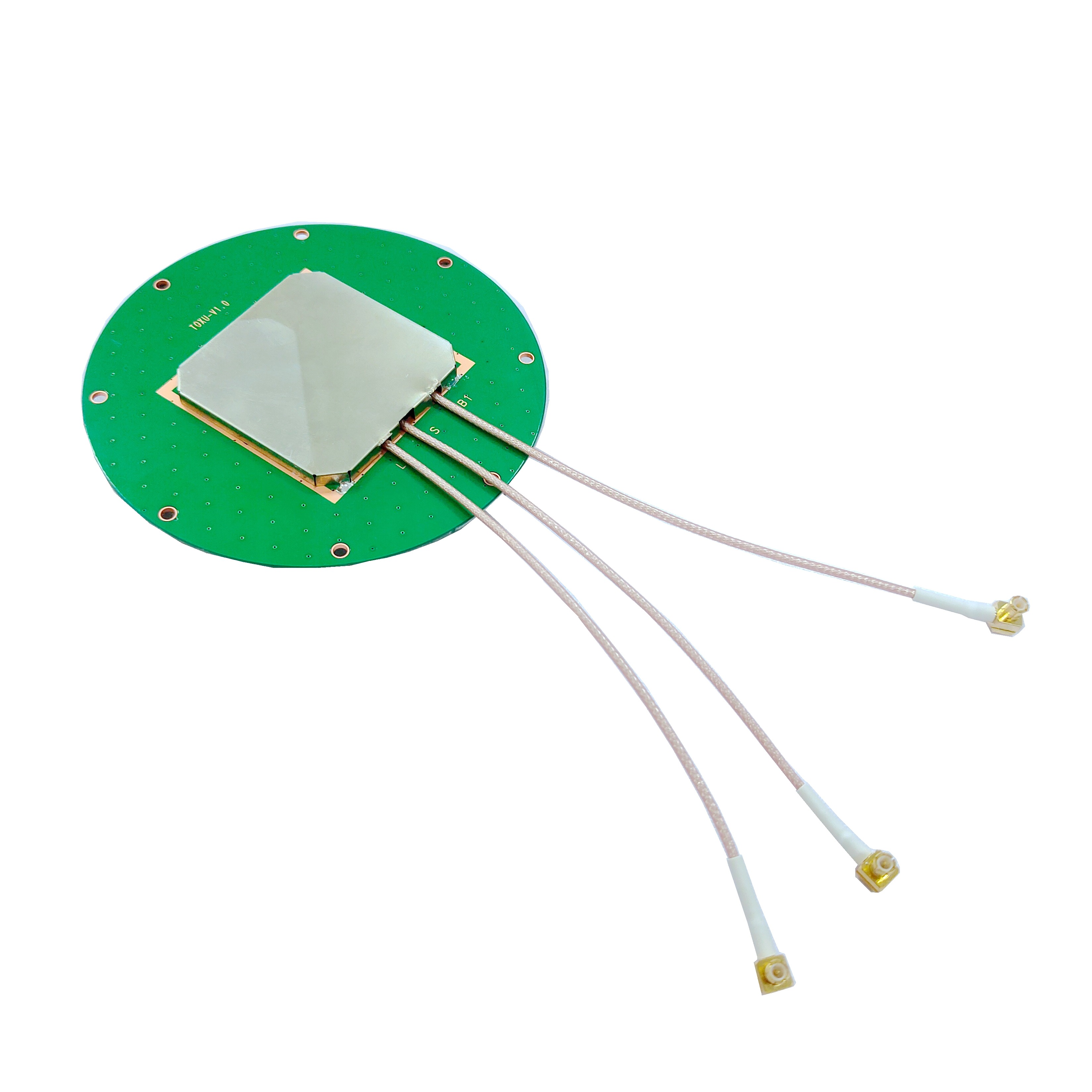
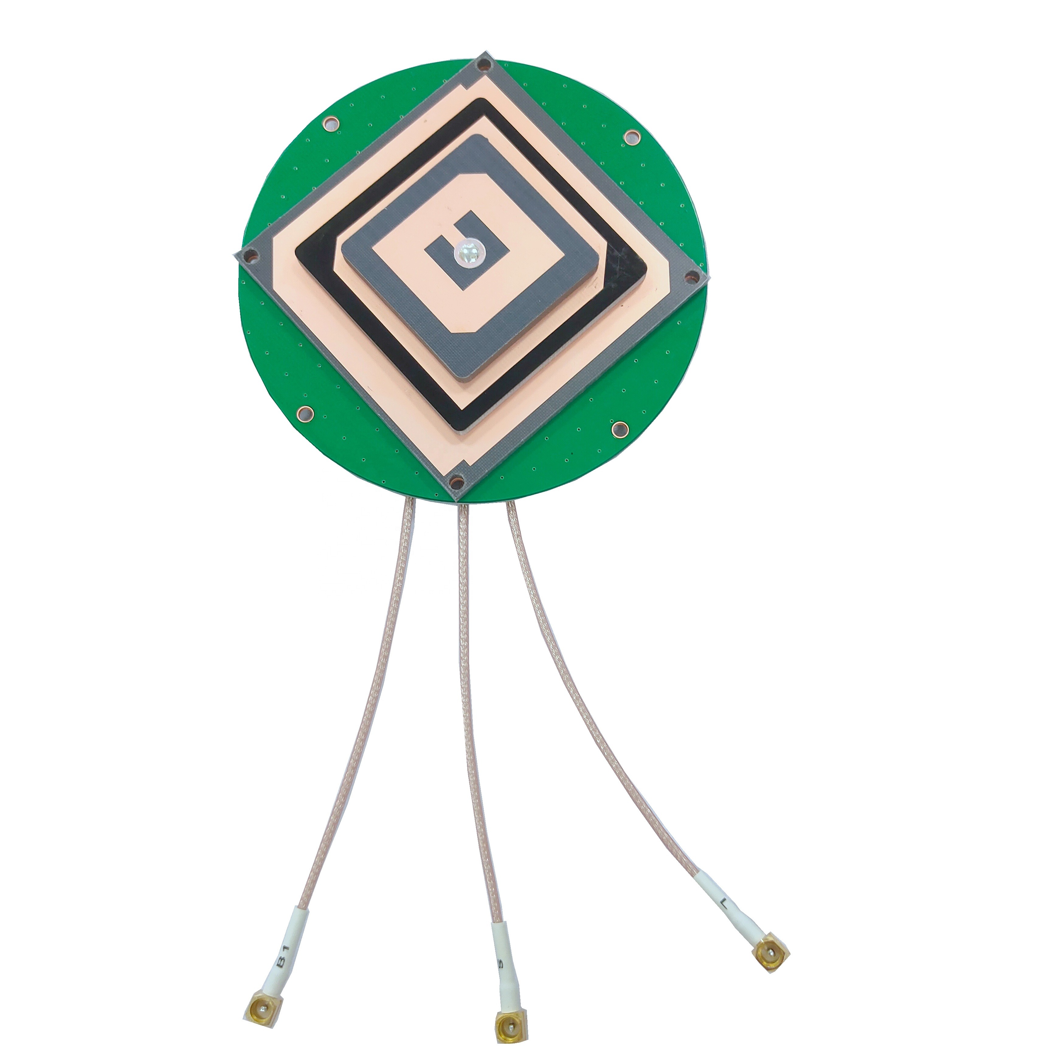
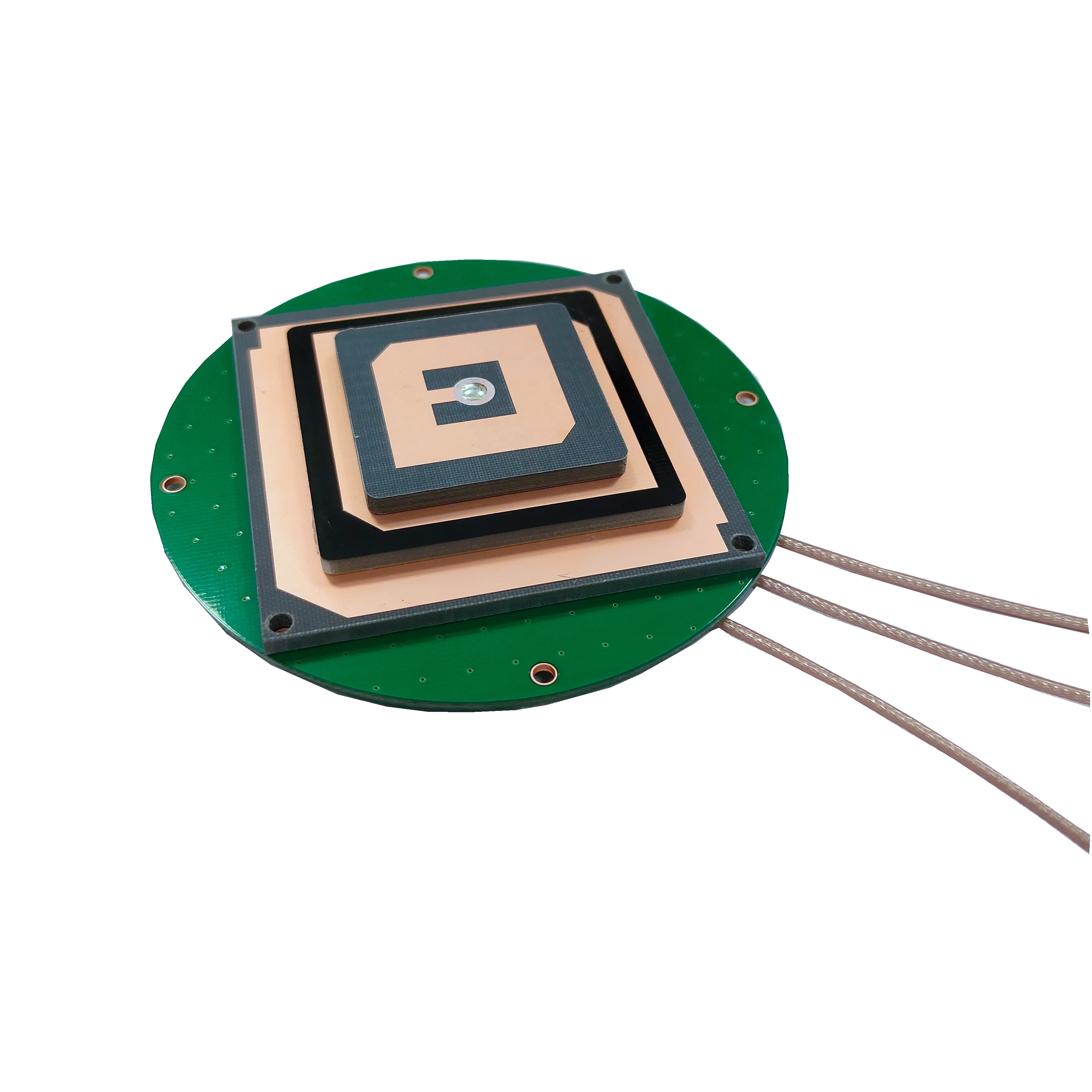
Radiating Element: The core signal-capturing component is a planar patch array made from high-conductivity materials like gold-plated copper or silver. The array consists of multiple patches arranged in a grid or circular pattern, each tuned to a specific frequency band. The patches are etched onto a low-loss dielectric substrate (e.g., ceramic or Rogers 4350) with a high dielectric constant, which allows for compact design while maintaining signal efficiency. The substrate’s low loss tangent (<0.001) minimizes energy dissipation, ensuring weak signals from distant satellites are preserved.
Ground Plane: A thick (3–5 mm) ground plane, typically made from aluminum or brass, is mounted beneath the radiating element. It serves three key purposes: reflecting upward-traveling signals to enhance gain, shielding the antenna from electromagnetic interference (EMI) from the surveying equipment or ground, and providing mechanical stability. The ground plane is often larger than the radiating array (20–30 cm in diameter) to maximize sky coverage and reduce edge diffraction, which can distort the radiation pattern.
Low-Noise Amplifier (LNA) with Gain Flatness: To amplify weak signals from multiple constellations without introducing noise, the antenna includes a broadband LNA with a noise figure of <0.8 dB. The LNA is designed to provide flat gain (±0.5 dB) across all supported frequency bands, ensuring signals from low-power constellations (e.g., Galileo) are amplified as effectively as those from stronger ones (e.g., GPS). The LNA is positioned directly behind the radiating element to minimize signal loss before amplification.
Weatherproof Enclosure: Surveying antennas operate in outdoor environments, so the entire assembly is encased in a rugged, weatherproof radome. The radome is made from materials like fiberglass-reinforced polypropylene or PEEK, which are transparent to GNSS frequencies (dielectric loss <0.02) and resistant to UV radiation, rain, dust, and extreme temperatures (-40°C to +70°C). The enclosure is rated IP67 or IP68, ensuring protection against submersion in water for short periods.
Connector and Cable: The antenna is connected to the surveying receiver via a low-loss coaxial cable (e.g., LMR-240) with a characteristic impedance of 50 ohms. The cable is shielded to prevent EMI and jacketed in a durable, oil-resistant material for longevity in field conditions. The connector (typically TNC or SMA) is weather-sealed with an O-ring to prevent moisture ingress, and it is mounted on the antenna’s base for easy access.
Multi-constellation precision surveying GNSS antennas operate by capturing, filtering, and amplifying signals from multiple satellite networks, then feeding this data to a receiver for integrated processing and high-precision positioning:
Signal Capture from Multiple Constellations: As the antenna is deployed in the field, its broadband radiating element captures signals from all visible GNSS satellites—for example, a GPS satellite transmitting on L1, a GLONASS satellite on G1, and a Galileo satellite on E1. The array design ensures that signals from each constellation are received with equal efficiency, regardless of their frequency or the satellite’s elevation angle.
Filtering and Amplification: The captured signals are first passed through band-pass filters that isolate each frequency band, removing out-of-band interference (e.g., cellular signals at 1800 MHz). This filtering is critical for preventing cross-talk between constellations—for instance, ensuring that a GLONASS G2 signal (1246 MHz) does not interfere with a GPS L2 signal (1227.60 MHz). The filtered signals are then amplified by the LNA, which boosts signal strength by 20–30 dB while adding minimal noise, preserving the signal-to-noise ratio (SNR) needed for precision measurements.
Signal Integration and Error Correction: The amplified signals from all constellations are transmitted to the surveying receiver, which uses advanced algorithms to integrate the data. The receiver first identifies the constellation and frequency of each signal, then applies constellation-specific correction models. For example, it uses Galileo’s precise orbit data (from the Galileo Navigation Message Authentication system) to correct orbital errors, while leveraging GPS’s ionospheric models to mitigate delays caused by the Earth’s ionosphere. By combining data from multiple constellations, the receiver can cross-validate measurements: if a GPS satellite’s signal indicates a position error, the receiver can use data from a BeiDou satellite to correct it.
Carrier-Phase Measurement for High Precision: Unlike consumer-grade GNSS systems that use code-phase measurements (for meter-level accuracy), multi-constellation precision surveying antennas rely on carrier-phase measurements. The carrier wave of a GNSS signal has a much shorter wavelength (e.g., 19 cm for GPS L1) than the code, allowing for sub-centimeter precision. The receiver tracks the phase of the carrier wave from each satellite, and by comparing phase differences between multiple constellations, it resolves integer ambiguities (the number of full carrier cycles between the satellite and antenna)—a key step in achieving centimeter-level accuracy.
Dynamic Adaptation to Signal Conditions: The antenna and receiver work together to adapt to changing environmental conditions. If the number of visible GPS satellites drops due to a passing cloud, the receiver automatically prioritizes signals from GLONASS or Galileo to maintain positioning accuracy. Similarly, if a satellite’s signal is affected by multipath interference (e.g., reflection off a building), the receiver uses data from other constellations to filter out the error, ensuring consistent performance.
Advantages of Multi-constellation Precision Surveying GNSS Antennas
These antennas offer a range of benefits that make them indispensable for high-precision surveying:
Enhanced Positioning Accuracy and Reliability: By accessing signals from multiple constellations, these antennas reduce the impact of individual satellite errors (e.g., orbital inaccuracies or clock drift). For example, if a GPS satellite has a temporary clock error, the receiver can use data from a Galileo satellite to correct it, resulting in centimeter-level accuracy even when single-constellation systems would fail. This reliability is critical for applications like cadastral surveying, where legal property boundaries require absolute precision.
Improved Performance in Challenging Environments: In urban canyons, dense forests, or mountainous terrain, single-constellation antennas often lose signal lock due to blockages. Multi-constellation antennas, with their larger pool of satellites, are far more resilient. For instance, in a city with tall buildings blocking GPS signals from the south, the antenna can still receive signals from GLONASS satellites to the north, ensuring continuous positioning. This capability reduces surveying downtime and eliminates the need for time-consuming rework.
Faster Signal Acquisition and Ambiguity Resolution: More visible satellites mean the receiver can acquire signals and resolve integer ambiguities (a prerequisite for RTK precision) much faster. A multi-constellation antenna may resolve ambiguities in 1–2 minutes, compared to 5–10 minutes for a single-constellation antenna. This speed is a major advantage for large-scale projects, such as mapping a vast agricultural field, where time efficiency directly impacts productivity.
Global Coverage and Regional Optimization: Multi-constellation antennas provide global coverage by leveraging constellations with complementary orbital paths. For example, GLONASS satellites have inclined orbits that improve coverage in high-latitude regions (e.g., Scandinavia or Alaska), where GPS coverage is weaker. Regional constellations like QZSS (optimized for East Asia) and NavIC (South Asia) further enhance performance in their respective areas, ensuring that surveyors can work with precision anywhere in the world.
Future-Proofing for Emerging Constellations: As new GNSS constellations (e.g., BeiDou’s global expansion or Galileo’s Full Operational Capability) are deployed, multi-constellation antennas can be firmware-upgraded to support new frequency bands. This future-proofing ensures that surveying equipment remains relevant for years, reducing the need for costly hardware replacements.
Challenges and Limitations
Despite their advantages, multi-constellation precision surveying GNSS antennas face several challenges:
Increased Complexity and Cost: Designing antennas to support multiple constellations requires more advanced engineering, higher-quality materials, and rigorous testing—all of which drive up costs. A multi-constellation antenna may cost 50–100% more than a single-constellation model, which can be a barrier for small surveying firms or budget-constrained projects. Additionally, the receiver software needed to integrate data from multiple constellations is more complex, requiring specialized training to operate effectively.
Higher Power Consumption: The broadband LNA and additional filtering circuitry in multi-constellation antennas consume more power than single-constellation models (typically 15–30 mA vs. 5–10 mA). This increased power demand can shorten battery life in portable surveying equipment, such as backpack-mounted receivers or drones, requiring more frequent recharging or larger batteries—both of which add weight and inconvenience.
Sensitivity to Cross-Constellation Interference: While filters reduce interference, signals from different constellations operating on adjacent bands (e.g., GPS L5 at 1176.45 MHz and Galileo E5a at 1176.45 MHz, which are nearly identical) can still cause cross-talk. This interference can degrade signal quality, especially in areas with high signal density (e.g., near a satellite ground station), requiring advanced receiver algorithms to mitigate.
Calibration Complexity: Multi-constellation antennas require more extensive calibration than single-constellation models. Each frequency band and constellation has unique phase center characteristics, so the antenna must be calibrated across a wide range of frequencies and angles. This calibration is typically done in anechoic chambers with robotic positioners, adding to manufacturing time and cost.
Compatibility Issues with Legacy Equipment: Some older surveying receivers may not support all modern constellations, limiting the utility of multi-constellation antennas. Surveyors may need to upgrade their receivers to fully leverage the antenna’s capabilities, which adds to the overall investment cost.
Applications
Multi-constellation precision surveying GNSS antennas are deployed across industries where accuracy, reliability, and global coverage are critical:
Cadastral and Land Surveying: These antennas are used to define legal property boundaries with centimeter-level precision, ensuring that land ownership records are accurate and dispute-free. In regions with complex terrain (e.g., mountainous areas of the Himalayas), the antenna’s ability to access multiple constellations ensures that even remote parcels of land can be surveyed reliably.
Construction and Infrastructure Monitoring: Construction firms use these antennas for staking out foundations, roads, and bridges, ensuring that structures are built according to design specifications. They are also used for deformation monitoring—tracking tiny movements (1–2 mm per year) in bridges, dams, and skyscrapers. The multi-constellation capability ensures that monitoring continues even if one constellation’s signals are blocked by construction equipment or temporary structures.
Agriculture and Precision Farming: In precision agriculture, these antennas guide autonomous tractors, planters, and harvesters, enabling precise seed placement, variable-rate fertilization, and efficient crop harvesting. The ability to operate in diverse environments—from flat farmlands to hilly vineyards—ensures that farmers can optimize yields regardless of terrain. For example, a vineyard in Tuscany can use the antenna to map soil variability with centimeter accuracy, ensuring that each vine receives the optimal amount of water and nutrients.
Environmental and Geoscience Research: Environmental scientists use these antennas to track changes in landscapes over time, such as glacial retreat, coastal erosion, or volcanic activity. In the Arctic, where GPS coverage is limited, the antenna’s ability to access GLONASS and Galileo signals allows researchers to monitor ice sheet movements with unprecedented precision, providing critical data for climate change studies.
Mining and Quarrying: Mining operations use these antennas to guide drilling equipment, monitor slope stability, and map ore deposits. In open-pit mines, where dust and heavy machinery can block signals, the multi-constellation capability ensures that positioning remains accurate, improving safety and efficiency. For example, a gold mine in Australia uses the antenna to track the movement of haul trucks, optimizing routes to reduce fuel consumption and increase productivity.
Future Trends
The development of multi-constellation precision surveying GNSS antennas is shaped by advances in satellite technology, materials science, and artificial intelligence:
Support for New Frequency Bands and Constellations: As GNSS constellations expand (e.g., BeiDou’s B3I band, Galileo’s E6 band), future antennas will support an even broader range of frequencies. This will enable better error correction—for example, using Galileo’s E6 band (1278.75 MHz) to mitigate ionospheric delays more effectively—and improve performance in challenging environments.
AI-Driven Interference Mitigation: Artificial intelligence (AI) and machine learning algorithms will be integrated into receivers to better detect and filter out interference. These algorithms will analyze signal patterns from multiple constellations to identify and suppress noise from sources like jammers or multipath reflections, further improving accuracy and reliability.
Miniaturization and Integration with Other Sensors: Advances in materials science (e.g., metamaterials) will enable smaller Miniaturization and Integration with Other Sensors: Advances in materials science (e.g., metamaterials) will enable smaller, lighter multi-constellation antennas without sacrificing performance. Metamaterials—engineered structures with unique electromagnetic properties—can manipulate signal propagation to achieve high gain in compact form factors, making them ideal for portable surveying tools and drone-mounted systems. Additionally, future antennas will be integrated with complementary sensors such as LiDAR, inertial measurement units (IMUs), and cameras. This multi-sensor fusion will compensate for temporary GNSS signal loss (e.g., in urban canyons or tunnels) by using LiDAR for spatial mapping or IMUs for motion tracking, ensuring continuous high-precision positioning.
Energy Harvesting for Extended Battery Life: To address power consumption challenges, future antennas will incorporate energy harvesting technologies. Solar panels integrated into the antenna’s radome, or RF energy scavengers that capture ambient radio waves (from cellular or Wi-Fi signals), will supplement battery power. This will extend the operational life of portable surveying equipment—such as backpack receivers used in remote areas—reducing the need for frequent recharging and improving fieldwork efficiency.
Quantum-Enhanced Positioning: Research into quantum GNSS receivers is paving the way for antennas that leverage quantum mechanics to achieve unprecedented accuracy. Quantum receivers use atomic clocks and quantum sensors to measure signal phases with near-perfect precision, minimizing errors caused by noise and interference. While still in early stages, quantum-enhanced multi-constellation antennas could eventually deliver millimeter-level accuracy, revolutionizing applications like micro-deformation monitoring of critical infrastructure.
Cloud-Native Data Processing: Future multi-constellation systems will rely on cloud-native platforms for real-time data processing and correction. Antennas will transmit raw GNSS data to cloud servers, where advanced algorithms (powered by edge computing) will process signals from multiple constellations, apply corrections, and return positioning results to the field in milliseconds. This shift will reduce the computational load on on-site receivers, enabling smaller, more energy-efficient devices while leveraging the cloud’s scalability for large-scale surveying projects.
Conclusion
Multi-constellation precision surveying GNSS antennas have redefined the standards of accuracy and reliability in geospatial measurement, marking a pivotal shift from single-constellation dependency to a more robust, globally capable approach. By integrating signals from GPS, GLONASS, Galileo, BeiDou, and regional systems, these antennas overcome the limitations of traditional models—delivering centimeter-level accuracy even in signal-challenged environments like urban canyons, dense forests, and high-latitude regions. Their design, optimized for broadband frequency support, low phase center variation, and weather resilience, ensures they meet the rigorous demands of professional surveying, where precision directly impacts project success, legal compliance, and safety.
The advantages of these antennas—enhanced reliability, faster ambiguity resolution, global coverage, and future-proofing—have made them indispensable across industries, from cadastral surveying that defines property boundaries to environmental research tracking climate-driven landscape changes. While challenges like higher costs, power consumption, and calibration complexity persist, ongoing innovations in materials, AI, and sensor fusion are steadily addressing these barriers.
Looking ahead, the evolution of multi-constellation precision surveying GNSS antennas will be shaped by miniaturization, quantum technology, and cloud integration—trends that will expand their utility to even more compact devices and extreme environments. As GNSS constellations continue to expand and mature, these antennas will remain at the forefront of geospatial innovation, enabling surveyors, engineers, and scientists to push the boundaries of what is possible in accurate, reliable measurement.
In essence, multi-constellation precision surveying GNSS antennas are not just tools—they are enablers of progress. They empower industries to build safer infrastructure, manage natural resources more sustainably, and resolve land disputes fairly, all while adapting to a world where precision and global connectivity are increasingly intertwined. As technology advances, their role in shaping a more accurate, data-driven future will only grow, solidifying their status as the backbone of modern geospatial measurement.

 86 0755 2819 9597
Lucy Yang | lucy.y@toxutech.com
Nicole Li | nicole@toxutech.com
Dotty Zhao | sales04@toxutech.com
Global Business Director / Sales Team / Global Operations


 En
En Cn
Cn Korean
 Home >


