

-
Products -PCBA Manufacturing RF Connectors RF Cable Assemblys Embedded Antennas External Antennas Positioning Chips and Modules
RF Connectors

RF Cable Assemblys
Embedded Antennas
External Antennas
Positioning Chips and Modules


 Language


Language


In the field of geospatial engineering, where measurements define land boundaries, guide infrastructure development, and monitor planetary changes, high-precision surveying Global Navigation Satellite System (GNSS) antennas stand as irreplaceable tools. These specialized antennas are engineered to deliver sub-centimeter to millimeter-level positioning accuracy—far exceeding the capabilities of consumer-grade GNSS antennas—making them essential for applications where even the smallest deviation can lead to costly errors, safety risks, or failed compliance. Unlike standard GNSS antennas, which prioritize portability or cost over precision, high-precision surveying models are optimized for stability, signal integrity, and error mitigation, enabling reliable performance in diverse environments from urban construction sites to remote wilderness areas.
High-precision surveying GNSS antennas achieve their exceptional accuracy by leveraging three core capabilities: multi-constellation support (GPS, GLONASS, Galileo, BeiDou, and regional systems like NavIC), multi-frequency reception (typically L1/L2/L5 for GPS, E1/E5a/E5b for Galileo), and rigorous design to minimize phase center variation (PCV)—a critical factor that directly impacts positioning precision. PCV, the tendency of an antenna’s effective signal-processing point to shift with satellite elevation or azimuth, is controlled to less than 1 millimeter in top-tier models, ensuring consistent distance measurements to satellites. Additionally, these antennas integrate low-noise amplification and advanced filtering to preserve weak satellite signals, even in challenging conditions such as dense foliage or near electromagnetic interference (EMI) sources.
The demand for high-precision surveying GNSS antennas has grown in tandem with the expansion of large-scale infrastructure projects (e.g., high-speed railways, smart cities), climate change monitoring (e.g., glacier tracking, sea-level rise), and precision agriculture. For example, in the construction of a cross-border tunnel, these antennas ensure that tunnel bores from opposite ends align within millimeters, avoiding catastrophic misalignment. In environmental science, they enable researchers to measure tiny crustal movements (1–2 mm per year) that signal volcanic activity or tectonic shifts. As industries and research fields increasingly require data-driven decisions based on exact geospatial coordinates, high-precision surveying GNSS antennas have become the gold standard for reliable measurement.
Core Design Features for Precision
High-precision surveying GNSS antennas are designed with meticulous attention to detail, where every component and dimension is optimized to minimize errors and maximize signal integrity:
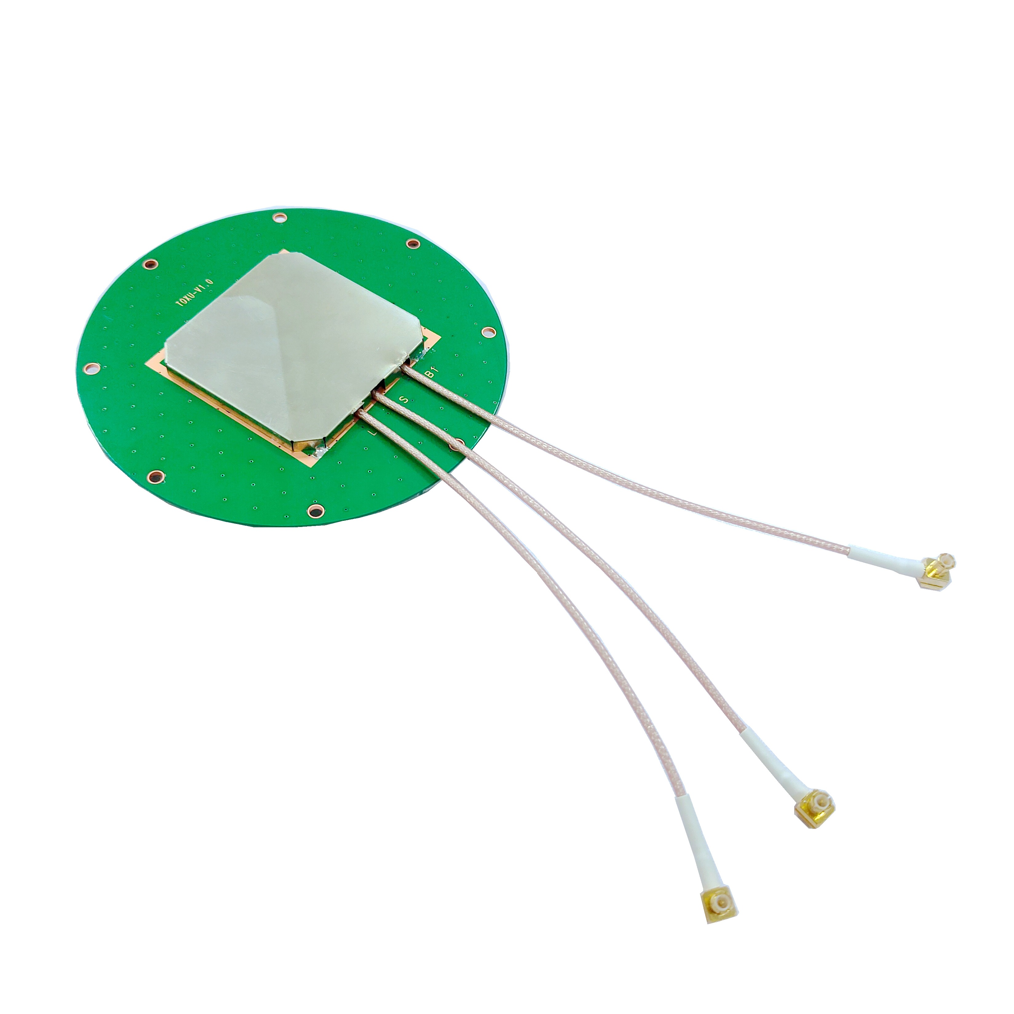
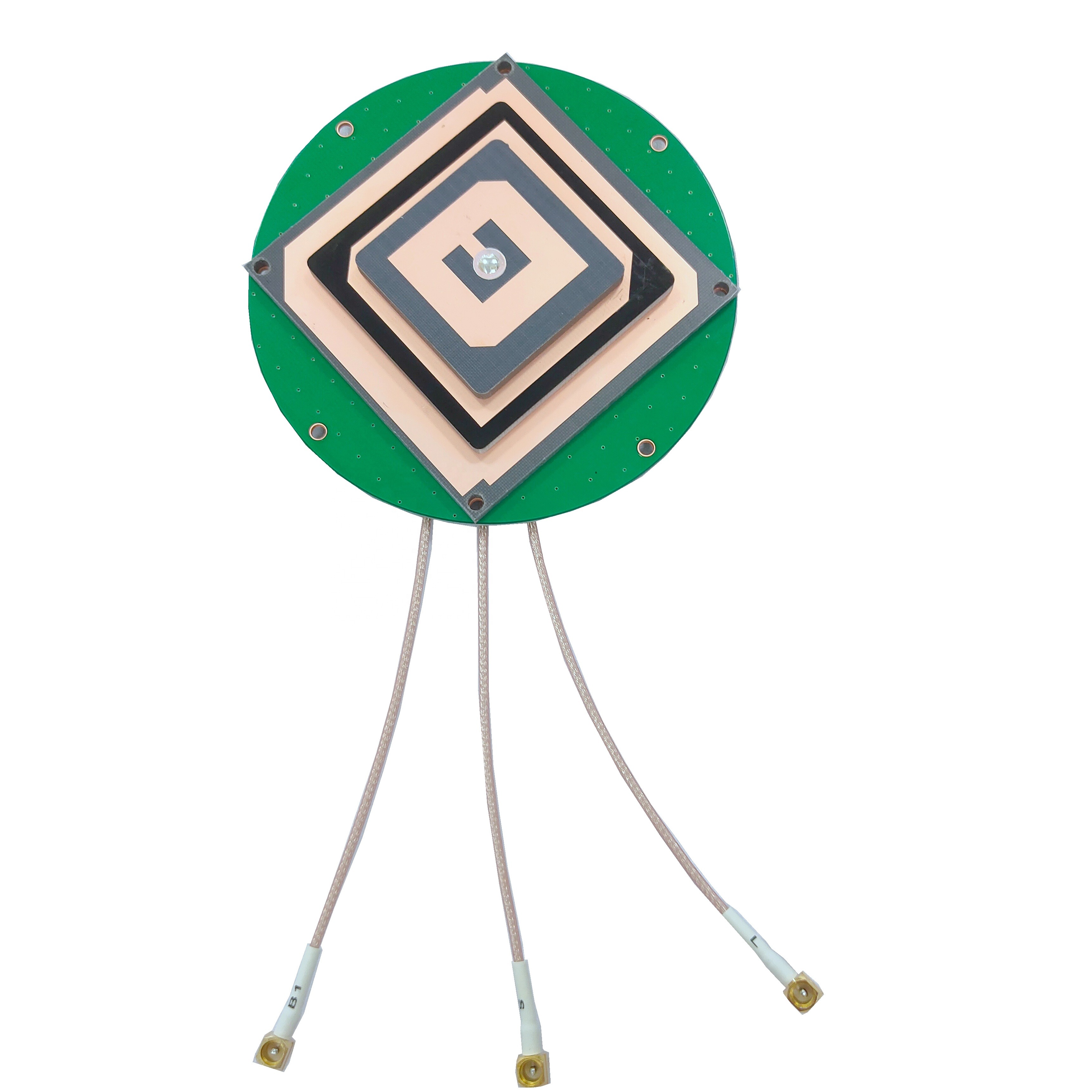
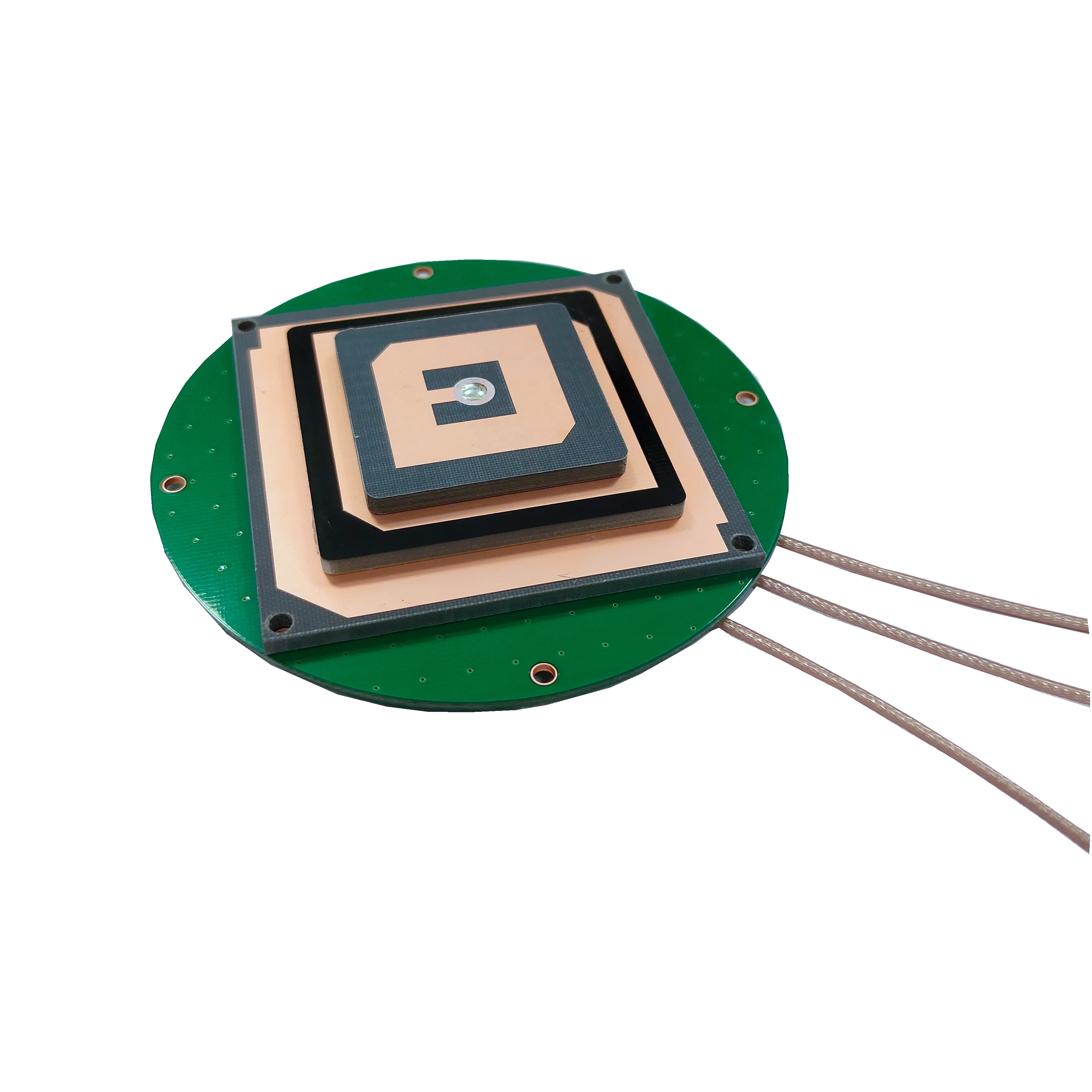
Multi-Frequency, Multi-Constellation Radiating Elements: The antenna’s radiating core is a planar patch array or helical design engineered to receive signals from multiple GNSS constellations and frequency bands. For example, a typical high-precision model supports GPS L1 (1575.42 MHz), L2 (1227.60 MHz), L5 (1176.45 MHz); Galileo E1 (1575.42 MHz), E5a (1176.45 MHz), E5b (1207.14 MHz); and BeiDou B1I (1561.098 MHz), B2I (1207.14 MHz). This multi-band capability is critical for correcting ionospheric delays—frequency-dependent errors caused by charged particles in Earth’s upper atmosphere. The radiating elements are arranged in a symmetric pattern (e.g., 4-element or 8-element arrays) to ensure uniform gain across all satellite angles, reducing PCV.
Low-Loss, High-Stability Dielectric Substrates: The radiating elements are mounted on a dielectric substrate (typically ceramic or high-performance polymer) with a high dielectric constant (εr = 20–40) and ultra-low loss tangent (<0.001). Ceramic substrates (e.g., alumina or barium titanate) are preferred for their thermal stability and consistent electrical properties, which minimize frequency drift caused by temperature changes. The substrate’s thickness and dielectric constant are tightly controlled (tolerances of ±0.01 mm and ±0.5% respectively) to ensure the antenna resonates precisely at target frequencies.
Rigid, High-Flatness Ground Plane: A large, flat ground plane (20–30 cm in diameter for ground-mounted models) serves as both a reflective surface and an EMI shield. Made from marine-grade aluminum or brass, the ground plane is machined to a flatness of <0.1 mm to avoid warping, which could distort the antenna’s radiation pattern. It extends beyond the radiating elements to reduce multipath interference—signals reflected off nearby surfaces that corrupt measurements—by absorbing or redirecting unwanted reflections. Some designs include concentric grooves or chamfers on the ground plane to further suppress multipath.
Ultra-Low Noise Amplifier (LNA): Positioned within 1–2 cm of the radiating elements, the LNA amplifies weak satellite signals (as low as -165 dBm) while adding minimal noise. High-precision antennas use LNAs with a noise figure of <0.8 dB—significantly lower than consumer antennas—to preserve the signal-to-noise ratio (SNR) critical for carrier-phase measurements. The LNA is often paired with a second-stage amplifier near the antenna’s output to compensate for signal loss in long coaxial cables (up to 10 meters), ensuring the receiver receives a strong, clean signal.
Phase Center Calibration and Correction: Every high-precision surveying GNSS antenna undergoes rigorous calibration in an anechoic chamber before leaving the factory. During calibration, the antenna is rotated through 360° in azimuth and 0–90° in elevation, and its phase center is measured at multiple frequencies. The resulting PCV data is compiled into a correction model (e.g., IGS-compatible PCV files) that the surveying receiver uses to adjust measurements in real time, eliminating residual phase errors. Advanced models include dynamic PCV correction, which accounts for temperature-induced shifts during field operation.
Construction Components
The physical construction of these antennas balances durability with precision, ensuring long-term performance in harsh field conditions:
Radiating Element Materials: The patch arrays are made from high-conductivity metals, such as gold-plated copper or oxygen-free copper, deposited via sputtering or electroplating. Gold plating (5–10 μm thick) enhances corrosion resistance and ensures consistent conductivity over years of outdoor use, critical for applications like coastal surveying where saltwater spray is prevalent. The metal layers are patterned with sub-millimeter precision using photolithography to ensure symmetric signal reception.
Hermetic Sealing and Weatherproofing: For outdoor use, the antenna is enclosed in a rugged radome made from fiberglass-reinforced polypropylene or PEEK (polyetheretherketone), materials that are transparent to GNSS frequencies (dielectric loss <0.02 at 1.5 GHz) and resistant to UV radiation, rain, and dust. The radome is bonded to the ground plane using a low-outgassing epoxy, creating a hermetic seal with an IP67 or IP68 rating. This prevents moisture ingress, which could short-circuit the LNA or alter the substrate’s dielectric properties.
Shielded Cable and Connectors: The antenna is connected to the surveying receiver via a low-loss coaxial cable (e.g., LMR-400 or Times Microwave LMR-240) with attenuation of <4 dB/10m at 1.5 GHz. The cable is shielded with a double braid of tinned copper to block EMI from nearby power lines, radios, or construction equipment. Connectors are precision-machined TNC or SMA types with gold-plated contacts and O-ring seals, ensuring a weatherproof, low-resistance connection that minimizes signal loss.
Vibration-Damping Mounting: To reduce mechanical stress on the radiating elements and substrate, the antenna is mounted on a vibration-damping base made from silicone or neoprene. This is critical for mobile applications (e.g., surveying vehicles or drones), where vibration can cause micro-shifts in the antenna’s components, introducing phase errors. The mounting base also allows for precise leveling of the antenna, ensuring the ground plane remains parallel to the horizon—essential for consistent radiation pattern performance.
Thermal Management: In extreme temperatures (-40°C to +70°C), the antenna’s components can expand or contract, altering PCV. To mitigate this, the substrate and ground plane are made from materials with matched thermal expansion coefficients (e.g., ceramic substrate paired with aluminum ground plane). Some high-end models include a thin layer of phase-change material between the substrate and ground plane, which absorbs heat in high temperatures and releases it in cold conditions, stabilizing the antenna’s operating temperature.
High-precision surveying GNSS antennas operate by capturing, amplifying, and filtering satellite signals in a way that preserves the fine details needed for sub-centimeter positioning. Their working principles are tightly linked to the requirements of advanced surveying techniques like Real-Time Kinematic (RTK) and Precise Point Positioning (PPP):
Multi-Band Signal Capture: The antenna’s radiating elements capture signals from multiple GNSS constellations and frequency bands simultaneously. For example, L1 signals (used in consumer devices) are paired with L2 or L5 signals, which have different ionospheric delay characteristics. By comparing the travel time of signals across bands, the receiver can model and correct for ionospheric errors—a major source of inaccuracy in single-band systems. The symmetric design of the radiating elements ensures that signals from satellites at any elevation or azimuth are received with consistent phase, minimizing PCV-induced errors.
Low-Noise Amplification: Weak satellite signals are immediately amplified by the LNA, which is positioned close to the radiating elements to reduce signal loss before amplification. The LNA’s ultra-low noise figure ensures that the amplified signal retains a high SNR (typically >40 dB), which is essential for resolving the carrier-phase of the GNSS signal. Unlike code-phase measurements (used in consumer GPS), carrier-phase measurements track the phase of the satellite’s radio wave (wavelength ~19 cm for L1), enabling distance calculations with millimeter-level precision.
Interference Filtering: After amplification, the signal passes through a series of band-pass filters that isolate the desired GNSS frequencies. These filters block out-of-band interference from sources like 4G/5G cellular networks (700 MHz–6 GHz), Wi-Fi (2.4/5 GHz), and industrial radios (433 MHz/900 MHz). Some antennas include adaptive notch filters that dynamically suppress strong interference sources detected by the receiver, ensuring the GNSS signal remains uncorrupted even in EMI-dense environments like construction sites.
Phase-Phase Measurement and RTK/PPP Integration: The filtered, amplified signal is sent to the surveying receiver, which uses carrier-phase measurements to calculate the antenna’s position. For RTK operation, the receiver pairs the antenna’s data with correction signals from a nearby base station (known coordinates). The base station calculates errors (ionospheric, tropospheric, satellite clock) and transmits them to the rover antenna, which applies the corrections to its own measurements. The antenna’s low PCV ensures that the carrier-phase data is consistent, allowing the receiver to resolve “integer ambiguities”—the number of full carrier-wave cycles between the satellite and antenna—with high confidence, a key step in achieving centimeter-level accuracy. For PPP, the receiver uses global correction networks (e.g., IGS) instead of a local base station, with the antenna’s multi-band data enabling faster ambiguity resolution.
Environmental Error Mitigation: The antenna’s design actively mitigates environmental errors. The ground plane reduces multipath by reflecting unwanted signals away from the radiating elements, while the radome prevents moisture from altering the substrate’s dielectric properties. Thermal management features stabilize the antenna’s temperature, minimizing frequency drift and PCV shifts. In dynamic applications (e.g., drone surveying), the vibration-damping mount ensures that the antenna remains aligned, even as the platform moves.
Advantages of High-Precision Surveying GNSS Antennas
These antennas offer transformative benefits that make them indispensable for demanding geospatial tasks:
Sub-Centimeter to Millimeter-Level Accuracy: The primary advantage is their ability to deliver positioning accuracy of 0.5–2 cm horizontally and 1–5 cm vertically (RTK) or 2–5 cm horizontally (PPP). This level of precision is unmatched by any other consumer or industrial GNSS solution, enabling applications like cadastral surveying (defining legal land boundaries) and structural deformation monitoring (tracking tiny shifts in bridges or dams).
Reliability in Challenging Environments: Multi-constellation and multi-band support ensures the antenna maintains signal lock even in areas with partial satellite obstruction, such as urban canyons or dense forests. For example, in a city with tall buildings, the antenna can switch between GPS, Galileo, and BeiDou signals to maintain a sufficient number of satellites for accurate positioning—something single-constellation antennas cannot do.
Long-Term Stability: Rigorous calibration, high-quality materials, and thermal management ensure the antenna’s performance remains consistent over time. Drift in PCV or gain is typically <0.1 mm per year, making these antennas suitable for long-term monitoring projects (e.g., tracking glacier retreat over a decade) where consistent measurements are critical.
Reduced Dependence on Ground Control Points (GCPs): In traditional surveying, GCPs (marked points with known coordinates) are used to correct for positioning errors. High-precision GNSS antennas eliminate or drastically reduce the need for GCPs, as their intrinsic accuracy ensures geotagged data is reliable. This saves significant time and labor, especially in large or remote areas where placing GCPs is logistically challenging.
Compatibility with Advanced Surveying Workflows: These antennas integrate seamlessly with modern surveying tools, including robotic total stations, LiDAR scanners, and drone mapping systems. This compatibility enables hybrid workflows—e.g., combining GNSS data with LiDAR point clouds—to create highly detailed 3D models of terrain or structures, expanding the scope of possible projects.
Challenges and Limitations
Despite their strengths, high-precision surveying GNSS antennas face several challenges that users must address:
High Cost: These antennas are significantly more expensive than standard GNSS antennas, with prices ranging from \(1,500 to \)10,000. The cost stems from precision manufacturing, rigorous calibration, and high-quality materials. This can be a barrier for small surveying firms or projects with limited budgets, though the long-term savings in time and labor often offset the upfront investment.
Size and Weight Constraints: Ground-mounted high-precision antennas are often large (20–30 cm diameter) and heavy (1–3 kg), making them less suitable for portable applications like backpack-mounted surveying or small drones. While miniaturized models exist (10–15 cm diameter), they may sacrifice slight gain or PCV performance compared to larger counterparts.
Sensitivity to Installation: Even the most precise antenna will underperform if installed incorrectly. The antenna must be leveled to within 0.1° of horizontal, and the ground plane must be free from nearby metal objects (e.g., vehicles, fences) that can distort the radiation pattern. Improper cable routing or loose connectors can introduce signal loss, reducing SNR and accuracy.
Multipath Interference in Complex Terrain: While the ground plane and filtering reduce multipath, extreme environments—such as near water bodies, glass buildings, or reflective surfaces—can still cause residual multipath errors. These errors can be 2–5 cm, requiring additional post-processing or the use of specialized algorithms to filter out corrupted data.
Power Consumption: The ultra-low noise LNA and multi-band circuitry consume more power than standard antennas (150–300 mA at 5V). This can be a challenge for battery-powered portable receivers, requiring larger batteries or more frequent recharging in remote areas without power access.
Applications
High-precision surveying GNSS antennas are deployed in diverse fields where accuracy is non-negotiable:
Cadastral and Land Surveying: These antennas define legal land boundaries with sub-centimeter precision, ensuring compliance with local land registry standards. Surveyors use them to map property lines, resolve land disputes, and update cadastral databases, reducing the risk of legal challenges due to inaccurate measurements.
Infrastructure Construction and Monitoring: In large-scale projects like high-speed railways, bridges, and skyscrapers, the antennas guide construction equipment (e.g., excavators, graders) to follow design plans exactly. After construction, they monitor structural stability—for example, measuring tiny movements in a bridge’s deck caused by traffic or temperature changes—to detect early signs of stress.
Precision Agriculture: Farmers use these antennas to guide autonomous tractors, planters, and harvesters with centimeter accuracy. This enables precise seed placement, variable-rate fertilization, and targeted irrigation, reducing input costs by 10–20% and improving crop yields. The antennas also map soil variability, helping farmers optimize land use.
Environmental and Climate Monitoring: Researchers use high-precision GNSS antennas to track natural phenomena such as glacier retreat, sea-level rise, and tectonic plate movement. For example, antennas installed on Antarctic glaciers measure annual ice loss with millimeter precision, providing critical data for climate change models. In volcanic regions, they detect pre-eruption ground deformation, enabling early warnings.
Mining and Quarrying: Mining operations use these antennas to map ore deposits, monitor slope stability, and guide drilling equipment. The accuracy ensures that ore is extracted efficiently, minimizing waste, while slope monitoring prevents catastrophic landslides. The antennas also help comply with environmental regulations by tracking the impact of mining on surrounding terrain.
Aerospace and Defense: In aerospace, these antennas calibrate satellite ground stations and align aircraft components during manufacturing, ensuring precision in critical systems. Defense applications include guiding precision weapons, mapping battlefields, and tracking military assets with sub-meter accuracy.
Future Trends
The evolution of high-precision surveying GNSS antennas is driven by advances in satellite technology, materials science, and artificial intelligence:
Integration with Next-Generation GNSS Constellations: As new GNSS constellations (e.g., BeiDou-3, Galileo Second Generation) expand and add new frequency bands (e.g., GPS L1C, Galileo E6), antennas will support an even broader range of signals. This will enhance redundancy and accuracy, especially in polar regions or remote areas where current constellations have gaps.
AI-Driven Error Mitigation: Machine learning algorithms will be integrated into antennas or receivers to dynamically detect and correct errors. For example, AI can analyze historical multipath patterns in a specific location to predict and filter out interference in real time, improving accuracy in urban or reflective environments. AI can also optimize LNA gain and filter settings based on current signal conditions.
Miniaturization with Metamaterials: Metamaterials—engineered materials with unique electromagnetic properties—will enable smaller, lighter high-precision antennas. These materials can manipulate radio waves to achieve the same gain and PCV performance as larger antennas but in a compact form factor (e.g., 5–10 cm diameter). This will expand their use in small drones, wearable surveying tools, and IoT sensors.
Quantum-Enhanced Sensing: Research into quantum GNSS receivers could lead to antennas that are immune to jamming and spoofing, while providing even higher accuracy. Quantum sensors use quantum entanglement to measure signal phases with unprecedented precision, potentially pushing accuracy into the sub-millimeter range.
Energy Harvesting and Sustainability: Future antennas will integrate energy harvesting technologies, such as solar cells or RF energy scavengers, to power the LNA and electronics. This will extend battery life in portable applications, reducing the need for frequent recharging. Manufacturers will also use eco-friendly materials (e.g., recycled metals, biodegradable polymers) to reduce environmental impact.
5G and LEO Satellite Integration: 5G networks will enable faster transmission of RTK correction data, extending the range of network RTK (NRTK) to remote areas. Low Earth Orbit (LEO) satellite constellations (e.g., Starlink, OneWeb) will provide global, low-latency correction data, eliminating reliance on ground-based base stations and enabling high-precision positioning anywhere on Earth.
Conclusion
High-precision surveying GNSS antennas are the backbone of modern geospatial measurement, enabling the accuracy and reliability that define critical projects in construction, environmental science, and land management. Their design—optimized for multi-band reception, low PCV, and rugged durability—addresses the unique challenges of field surveying, from EMI interference to extreme weather. By delivering sub-centimeter to millimeter-level accuracy, these antennas have transformed how we map the planet, build infrastructure, and monitor natural systems, replacing labor-intensive traditional methods with efficient, data-driven workflows.
While challenges such as cost, size, and installation complexity persist, ongoing innovations in materials, AI, and satellite technology are addressing these limitations. Future antennas will be smaller, smarter, and more accessible, expanding their role in emerging fields like autonomous construction, precision robotics, and global climate monitoring.
In a world where precise geospatial data is essential for sustainable development, safety, and scientific progress, high-precision surveying GNSS antennas will remain indispensable. Their ability to turn satellite signals into exact coordinates not only drives efficiency and innovation but also ensures that the decisions we make—whether building a bridge, managing farmland, or protecting the environment—are based on the most accurate information available. As technology advances, these antennas will continue to redefine the boundaries of what is possible in geospatial measurement, shaping a more precise and connected world.

 86 0755 2819 9597
Lucy Yang | lucy.y@toxutech.com
Nicole Li | nicole@toxutech.com
Dotty Zhao | sales04@toxutech.com
Global Business Director / Sales Team / Global Operations


 En
En Cn
Cn Korean
 Home >


