

-
Products -PCBA Manufacturing RF Connectors RF Cable Assemblys Embedded Antennas External Antennas Positioning Chips and Modules
RF Connectors

RF Cable Assemblys
Embedded Antennas
External Antennas
Positioning Chips and Modules


 Language


Language


Global Navigation Satellite Systems (GNSS) have revolutionized the field of surveying, enabling highly accurate positioning and measurements. At the heart of any GNSS - based surveying system lies the GNSS antenna, a critical component that plays a pivotal role in determining the overall performance and accuracy of the system. High - precision surveying GNSS antennas are designed to meet the stringent requirements of applications where millimeter - to - centimeter level accuracy is essential, such as geodetic surveying, construction, and precision agriculture.
1.1 Importance in Surveying
In traditional surveying methods, the use of tapes, theodolites, and total stations was common. However, these methods were often time - consuming, labor - intensive, and limited in terms of accuracy over large areas. GNSS technology, with its high - precision antennas, has changed this landscape. A high - precision GNSS antenna can capture signals from multiple satellites simultaneously. By measuring the time it takes for these signals to reach the antenna from the satellites, the receiver can calculate its position on the Earth's surface with remarkable accuracy.
For example, in geodetic surveying, which is concerned with accurately measuring the shape and size of the Earth and the precise positions of points on its surface, high - precision GNSS antennas are indispensable. They can detect even the slightest movements of tectonic plates over time, which is crucial for earthquake monitoring and understanding the Earth's crustal dynamics. In construction projects, especially large - scale infrastructure projects like bridges and high - rise buildings, accurate positioning is vital. High - precision GNSS antennas enable surveyors to set out the exact location of building foundations, ensuring that the structure is built in the correct place and to the required specifications.
1.2 Market Trends
The market for high - precision surveying GNSS antennas has been growing steadily in recent years. This growth is driven by several factors. Firstly, there is an increasing demand for accuracy in various industries. As technology advances, more and more applications require sub - centimeter level positioning accuracy. For instance, in precision agriculture, farmers use high - precision GNSS - equipped tractors and drones to precisely apply fertilizers and pesticides, reducing waste and increasing crop yields. This has led to a greater need for reliable and accurate GNSS antennas.
Secondly, the expansion of GNSS constellations has also contributed to the growth of the market. In addition to the well - known GPS (Global Positioning System) constellation, there are now other constellations such as GLONASS (Globalnaya Navigatsionnaya Sputnikovaya Sistema) from Russia, Galileo from the European Union, and BeiDou from China. These multiple constellations provide more satellites in the sky, which in turn improves the availability and accuracy of GNSS signals. High - precision GNSS antennas are being designed to be compatible with multiple constellations, allowing users to take advantage of the increased number of satellites.
Moreover, the development of new technologies in antenna design, such as advanced materials and manufacturing techniques, has led to the production of more efficient and cost - effective high - precision GNSS antennas. This has made them more accessible to a wider range of users, further fueling the growth of the market.
The design and construction of high - precision surveying GNSS antennas are complex processes that involve careful consideration of various factors to ensure optimal performance.
2.1 Radiating Elements
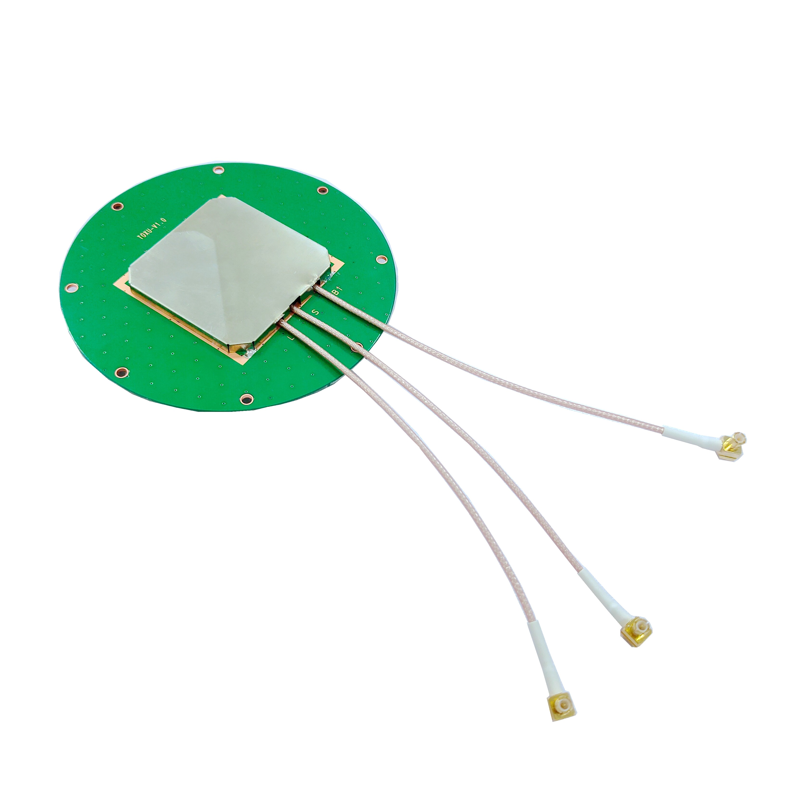
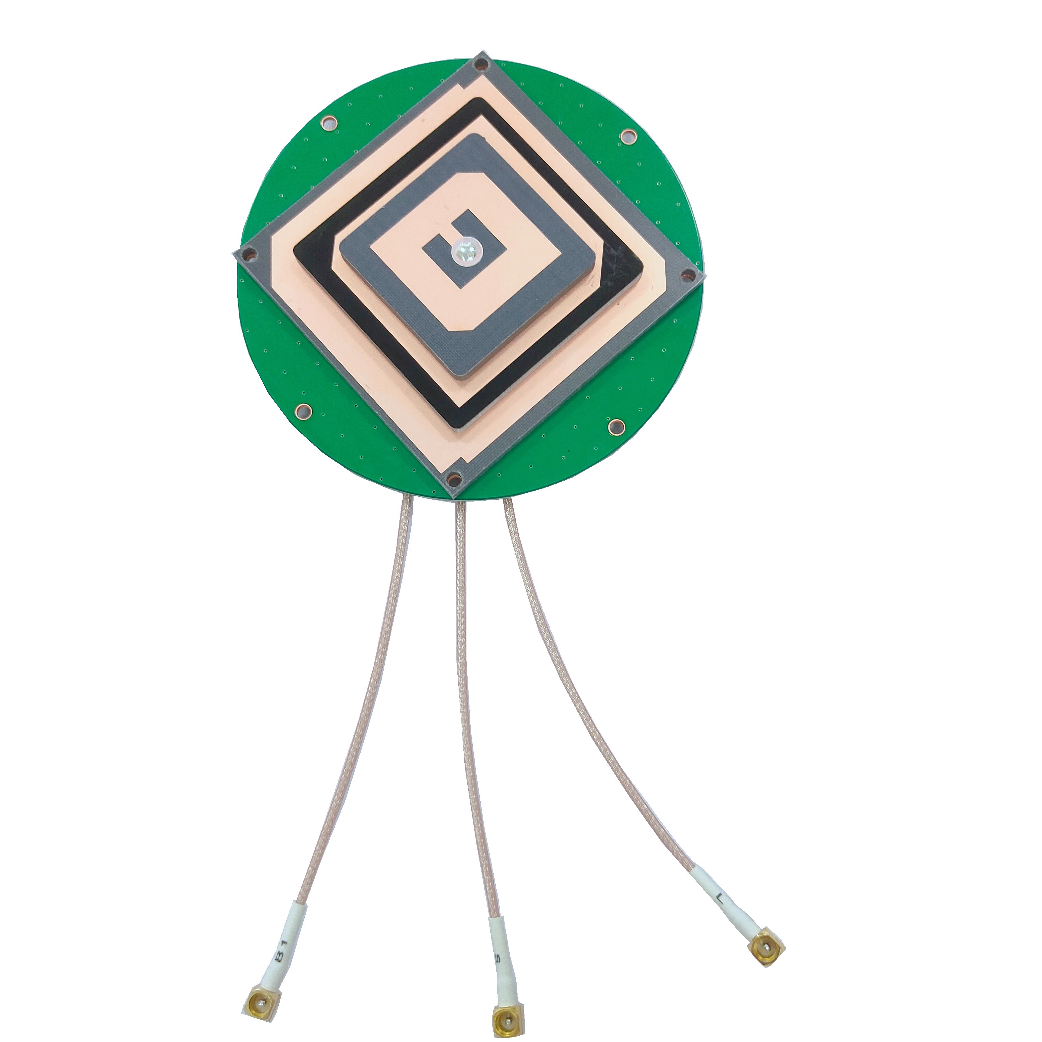
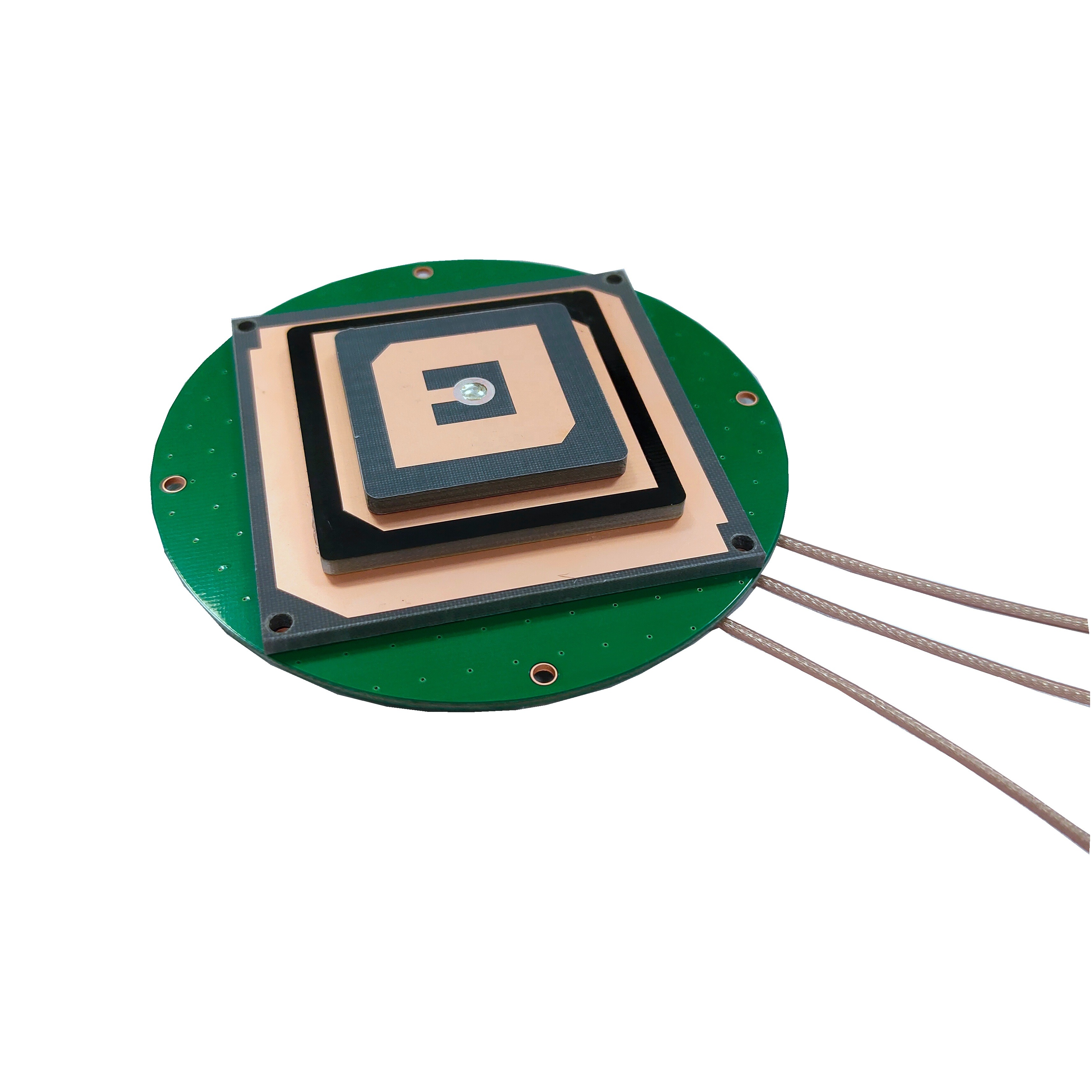
The radiating element is a fundamental part of the GNSS antenna. One of the most common types of radiating elements used in high - precision GNSS antennas is the ceramic patch antenna. The ceramic patch is typically a metalized square or disk printed on a dielectric substrate. It is set in the middle of a ground plane. For single - frequency applications, such as GPS L1 - only applications, a single - feed point patch antenna may be used. However, for more complex applications that require wider bandwidth and better circular polarization, a multi - feed point design is preferred.
With two or more feed points, the circular polarization of the antenna is significantly improved over a wider bandwidth. In a two - feed point antenna, the orthogonal currents flowing on the metalized surface of the patch are detected independently in both axes, with one feed for each axis. The two signals are then combined using a 90 - degree hybrid coupler to reconstruct the GNSS information from the satellite. To cover multiple frequency bands, such as L1 and L2 or L1 and L5, multiple patches can be stacked together.
Another type of radiating element is the helical antenna. Helical antennas are taller than patch antennas and consist of a coil of four metallic elements pointing upwards. They can achieve a precision of at least 5 mm. A key advantage of helical antennas is that they are less affected by the absence of a ground plane and can still mitigate multipath interference in such situations. However, their height can be a disadvantage in some applications. To address this, reduced - height versions of helical antennas are being developed.
2.2 Ground Plane Design
The ground plane is an important component of the GNSS antenna as it helps to improve the antenna's performance. It acts as a reflector, directing the radiated energy in the desired direction and reducing unwanted radiation. In high - precision GNSS antennas, the ground plane is often designed to be as large as possible within the constraints of the antenna's size and portability. A larger ground plane can improve the antenna's gain and reduce the effects of multipath interference.
Some high - precision GNSS antennas use a choke ring design as part of the ground plane. A choke ring consists of a series of concentric rings or grooves around the antenna. These rings are designed to suppress unwanted signals that arrive at the antenna from low - elevation angles, which are often the source of multipath interference. By reducing multipath, the choke ring helps to improve the accuracy of the antenna's positioning.
2.3 RF Front - End and Low - Noise Amplifier (LNA)
The RF front - end, which includes the low - noise amplifier (LNA), is responsible for capturing, filtering, and amplifying the weak GNSS signals received by the antenna. The LNA is a crucial component as it amplifies the signal without adding too much noise, which could degrade the signal - to - noise ratio and reduce the accuracy of the antenna.
High - precision GNSS antennas often feature LNAs with excellent out - of - band rejection performance. This means that the LNA can effectively suppress electromagnetic interference from other sources, such as communication base stations or other electronic devices. By suppressing this interference, the LNA helps to ensure the stability and reliability of the GNSS signals, especially in complex electromagnetic environments.
The RF front - end also includes filters that are designed to select the specific GNSS frequency bands of interest and reject signals outside of these bands. This helps to further improve the signal - to - noise ratio and the overall performance of the antenna.
2.4 Enclosure and Durability
Since high - precision surveying GNSS antennas are often used in outdoor and sometimes harsh environments, the enclosure of the antenna is designed to be durable and weather - resistant. Many antennas are rated to meet certain international standards, such as IP67 or IP69K. An IP67 - rated antenna is dust - tight and can be submerged in water up to 1 meter for 30 minutes without damage, while an IP69K - rated antenna can withstand high - pressure, high - temperature water jets.
The enclosure is also designed to protect the internal components of the antenna from mechanical shock and vibration. This is important in applications where the antenna may be subject to rough handling or where it is mounted on moving vehicles or equipment. Some antennas are built with ruggedized materials and shock - absorbing features to ensure their long - term reliability in challenging conditions.
The working principles of high - precision surveying GNSS antennas are based on the reception and processing of signals from GNSS satellites.
3.1 Signal Reception
GNSS satellites orbit the Earth at high altitudes and continuously transmit radio signals. These signals contain information about the satellite's position in space and the time at which the signal was transmitted. A high - precision GNSS antenna is designed to capture these weak signals, which have a very low power level when they reach the Earth's surface.
The antenna's radiating element, as described earlier, is optimized to receive signals in the specific frequency bands used by GNSS systems. For example, GPS satellites transmit signals in the L - band frequencies, which include L1 (1575.42 MHz), L2 (1227.60 MHz), and L5 (1176.45 MHz). The antenna is designed to be sensitive to these frequencies and to convert the received electromagnetic waves into electrical signals.
3.2 Signal Processing
Once the signals are received by the antenna, they are passed through the RF front - end, where they are amplified and filtered. The filtered signals are then sent to the GNSS receiver. The receiver's main task is to measure the time it takes for the signals to travel from the satellites to the antenna. This time measurement is based on the principle of time - of - flight.
By measuring the time delay for signals from at least four satellites, the receiver can calculate its three - dimensional position (latitude, longitude, and altitude) using a process called trilateration. In high - precision surveying, additional techniques are often used to improve the accuracy of the position calculation. One such technique is carrier - phase measurement.
Carrier - phase measurement involves measuring the phase of the carrier wave of the GNSS signal. The carrier wave is a continuous sine - wave signal that carries the information from the satellite. By measuring the phase of the carrier wave, the receiver can determine the distance to the satellite with much greater accuracy than just using the time - of - flight of the signal. However, carrier - phase measurement requires a very stable and accurate phase center in the antenna.
3.3 Multi - Constellation Operation
Modern high - precision surveying GNSS antennas are designed to work with multiple GNSS constellations. As mentioned earlier, in addition to GPS, there are GLONASS, Galileo, and BeiDou constellations. By being able to receive signals from multiple constellations, the antenna can increase the number of available satellites in the sky. This not only improves the availability of the GNSS signal but also enhances the accuracy of the positioning.
For example, in an urban canyon environment where some satellites may be blocked by tall buildings, having access to signals from multiple constellations increases the likelihood of receiving enough signals for accurate positioning. The antenna and receiver are designed to be able to distinguish between signals from different constellations and process them together to calculate the position.
High - precision surveying GNSS antennas offer numerous advantages, but they also face certain challenges.
4.1 Advantages
4.1.1 High Accuracy
The most significant advantage of high - precision surveying GNSS antennas is their ability to provide extremely accurate positioning. In applications such as geodetic surveying and construction, centimeter - to - millimeter level accuracy can be achieved. This high accuracy allows for precise mapping, alignment of structures, and monitoring of ground deformation. For example, in a large - scale bridge construction project, the use of high - precision GNSS antennas can ensure that the bridge components are installed with millimeter - level precision, which is crucial for the structural integrity and safety of the bridge.
4.1.2 Wide Coverage
GNSS antennas can receive signals from satellites that are orbiting the Earth, providing global coverage. This means that high - precision surveying can be carried out in remote areas where traditional surveying methods may be difficult or impossible to implement. In areas such as deserts, mountains, or forests, high - precision GNSS antennas can still provide accurate positioning data, enabling surveyors to map the terrain and carry out various projects.
4.1.3 Real - Time Data
GNSS antennas can provide real - time positioning data. This is extremely useful in applications such as construction machinery control and precision agriculture. In construction, real - time positioning data allows for the precise control of earth - moving equipment, ensuring that the excavation and grading are done accurately. In precision agriculture, real - time data can be used to adjust the application of fertilizers and pesticides as the tractor or drone moves across the field, optimizing the use of resources.
4.1.4 Reduced Labor and Time
Compared to traditional surveying methods, the use of high - precision GNSS antennas can significantly reduce the amount of labor and time required for a surveying project. With traditional methods, surveyors may need to set up multiple stations, measure angles and distances manually, and then calculate the positions. High - precision GNSS antennas can quickly and automatically calculate the position, reducing the need for extensive manual measurements and calculations.
4.2 Challenges
4.2.1 Multipath Interference
Multipath interference is one of the major challenges faced by high - precision surveying GNSS antennas. Multipath occurs when the GNSS signal reflects off surfaces such as buildings, water, or the ground before reaching the antenna. These reflected signals can interfere with the direct signal, causing errors in the time - of - flight measurement and thus reducing the accuracy of the positioning. To mitigate multipath interference, antenna designers use techniques such as choke ring designs, as mentioned earlier, and advanced signal processing algorithms in the receiver. However, multipath can still be a problem in complex environments with many reflecting surfaces.
4.2.2 Signal Blockage
In some environments, such as dense urban areas or thick forests, the GNSS signals may be blocked by buildings, trees, or other obstacles. This can reduce the number of available satellites and affect the accuracy and availability of the GNSS signal. To address this issue, some high - precision GNSS antennas are designed to have a wide beamwidth, allowing them to receive signals from satellites at lower elevation angles. Additionally, some systems use inertial navigation systems in combination with GNSS to provide continuous positioning information even when the GNSS signal is temporarily blocked.
4.2.3 Cost
High - precision surveying GNSS antennas, especially those with advanced features such as multi - constellation support, high - performance RF front - ends, and rugged enclosures, can be relatively expensive. The cost of these antennas may be a barrier for some users, especially those with limited budgets. However, as technology advances and the market grows, the cost of these antennas is gradually decreasing, making them more accessible.
4.2.4 Electromagnetic Interference
In today's electromagnetic - rich environment, high - precision GNSS antennas are vulnerable to electromagnetic interference from sources such as communication base stations, power lines, and other electronic devices. This interference can degrade the signal - to - noise ratio of the GNSS signal and reduce the accuracy of the antenna. To combat this, antenna designers incorporate features such as high - performance filters and LNAs with good out - of - band rejection in the antenna design.
5.1 Applications
5.1.1 Geodetic Surveying
As mentioned earlier, geodetic surveying is one of the key applications of high - precision surveying GNSS antennas. Geodetic surveyors use these antennas to measure the precise positions of points on the Earth's surface. This information is used for various purposes, such as mapping the Earth's surface, monitoring tectonic plate movements, and establishing reference frameworks for other surveying and mapping activities. High - precision GNSS antennas can detect changes in the Earth's crustal movements at a very small scale, which is crucial for understanding earthquake hazards and for long - term geodetic studies.
5.1.2 Construction
In the construction industry, high - precision surveying GNSS antennas are used for a wide range of tasks. They are used for site layout, where surveyors use the antennas to mark the exact location of building foundations, roads, and other structures. During the construction process, GNSS - equipped machinery, such as bulldozers and excavators, can use the high - precision positioning data from the antennas to accurately grade the land and place construction materials. In addition, high - precision GNSS antennas are used for monitoring the deformation of buildings and structures during and after construction to ensure their structural integrity.
5.1.3 Precision Agriculture
Precision agriculture has seen a significant increase in the use of high - precision surveying GNSS antennas. Farmers use these antennas to precisely control the application of fertilizers, pesticides, and water. By knowing the exact location of different areas in the field, they can adjust the amount of inputs based on the specific needs of the crops. For example, if a particular area of the field has poor soil fertility, the farmer can use a GNSS - equipped tractor to apply more fertilizer in that area. GNSS - equipped drones are also used in precision agriculture for crop monitoring and spraying, and the high - precision antennas on these drones ensure accurate positioning for targeted spraying.
5.1.4 Aerospace and Aviation
In the aerospace and aviation industries, high - precision surveying GNSS antennas are used for various applications. In aircraft navigation, these antennas provide accurate positioning information, which is crucial for safe takeoff, landing, and in - flight navigation. In satellite - based augmentation systems (SBAS), high - precision GNSS antennas are used to receive and process signals from geostationary satellites that provide additional corrections to the GNSS signals, improving the accuracy of aircraft navigation. In the aerospace industry, high - precision GNSS antennas are also used for satellite tracking and for the precise positioning of spacecraft during orbital maneuvers.
5.2 Future Trends
5.2.1 Integration with Other Technologies
In the future, high - precision surveying GNSS antennas are likely to be integrated with other technologies to provide even more accurate and comprehensive positioning solutions. For example, they may be integrated with inertial navigation systems (INS), which use accelerometers and gyroscopes to measure the motion of an object. By combining GNSS and INS, the system can provide continuous positioning information even when the GNSS signal is temporarily blocked. Another area of integration is with computer vision technology. Cameras can be used in conjunction with GNSS antennas to provide visual context to the positioning data, enabling more accurate mapping and navigation in complex environments.
5.2.2 Miniaturization and Cost Reduction
There is a growing trend towards miniaturization of high - precision surveying GNSS antennas. As technology advances, it is becoming possible to pack more functionality into smaller antenna designs. This miniaturization not only makes the antennas more portable but also reduces their cost. With the use of advanced materials and manufacturing techniques, such as 3D printing, it is expected that the cost of high - precision GNSS antennas will continue to decrease, making
them more accessible to small - scale users, such as individual farmers or small construction companies. For example, miniaturized high - precision GNSS antennas can be easily integrated into small drones used for agricultural monitoring, allowing small - scale farmers to access high - precision positioning data at a lower cost. This will further expand the application scope of high - precision surveying GNSS antennas.
5.2.3 Enhanced Anti - Interference Capabilities
As electromagnetic environments become increasingly complex, enhancing the anti - interference capabilities of high - precision surveying GNSS antennas will be a key future trend. Researchers and engineers are exploring new technologies and methods to improve the antenna's ability to resist various types of interference. One promising approach is the use of adaptive antenna arrays. An adaptive antenna array consists of multiple radiating elements and a signal processing system that can adjust the antenna's radiation pattern in real - time. By detecting the direction of interference signals, the array can suppress the interference by reducing the gain in the direction of the interference source while maintaining high gain in the direction of the GNSS satellites.
Another area of research is the development of new materials with better electromagnetic shielding properties. These materials can be used in the antenna's enclosure to block external electromagnetic interference. Additionally, advanced signal processing algorithms, such as machine learning - based interference detection and mitigation algorithms, are being developed. These algorithms can learn the characteristics of different types of interference signals and automatically adjust the processing parameters to suppress the interference, ensuring the stability and accuracy of the GNSS signals.
5.2.4 Higher Bandwidth and Multi - Frequency Support
With the continuous development of GNSS technology, more and more frequency bands are being used by different GNSS constellations. For example, Galileo uses frequency bands such as E1, E5a, E5b, and E6, while BeiDou has B1, B2, B3, and other frequency bands. In the future, high - precision surveying GNSS antennas will need to support a wider range of frequency bands to be compatible with all major GNSS constellations and their new signal types.
Higher bandwidth antennas will also enable the simultaneous reception of multiple signals from different frequency bands, which can improve the accuracy and reliability of positioning. For instance, receiving signals from both L1 and L5 frequency bands can help correct for ionospheric delays, which is a major source of positioning error. By supporting more frequency bands, high - precision GNSS antennas can take advantage of the complementary information provided by different signals, leading to more accurate and robust positioning solutions.
High - precision surveying GNSS antennas have emerged as a cornerstone technology in modern surveying and related fields, transforming the way we measure, map, and monitor the Earth's surface and man - made structures. Throughout this analysis, we have explored the various aspects of these antennas, from their overview and design to their working principles, advantages, challenges, applications, and future trends. The insights gained from this exploration highlight the critical role that high - precision surveying GNSS antennas play in driving innovation and improving efficiency across multiple industries.
In terms of their overview, high - precision surveying GNSS antennas have addressed the limitations of traditional surveying methods by providing unprecedented accuracy, global coverage, and real - time data acquisition. The importance of these antennas in geodetic surveying, construction, precision agriculture, and aerospace and aviation cannot be overstated. They have enabled tasks that were once considered difficult or impossible, such as detecting minute tectonic plate movements for earthquake monitoring, ensuring millimeter - level precision in large - scale construction projects, optimizing resource use in agriculture, and enhancing the safety and efficiency of aircraft navigation. The growing market for these antennas, driven by increasing demand for accuracy, the expansion of GNSS constellations, and advancements in antenna design technologies, further underscores their significance in today's technological landscape.
The design and construction of high - precision surveying GNSS antennas are a testament to the complexity and sophistication of modern engineering. The careful selection of radiating elements, such as ceramic patch antennas and helical antennas, along with the design of ground planes (including choke ring designs), RF front - ends with high - performance LNAs and filters, and durable enclosures, all contribute to the optimal performance of these antennas. Each component is designed to address specific challenges, such as improving circular polarization, reducing multipath interference, amplifying weak signals without adding excessive noise, and protecting the antenna from harsh environmental conditions. The integration of these components ensures that high - precision GNSS antennas can deliver the accuracy and reliability required for critical applications.
The working principles of high - precision surveying GNSS antennas, based on the reception and processing of GNSS satellite signals, are rooted in fundamental concepts of time - of - flight measurement and trilateration. The addition of carrier - phase measurement and multi - constellation operation has further enhanced the accuracy and availability of these antennas. By measuring the phase of the carrier wave, these antennas can achieve centimeter - to - millimeter level accuracy, while multi - constellation support ensures that they can receive signals from a large number of satellites, even in challenging environments such as urban canyons or dense forests. This combination of advanced measurement techniques and multi - constellation compatibility makes high - precision GNSS antennas highly versatile and reliable.
While high - precision surveying GNSS antennas offer numerous advantages, including high accuracy, wide coverage, real - time data, and reduced labor and time, they also face several challenges. Multipath interference, signal blockage, cost, and electromagnetic interference are among the key obstacles that need to be addressed. However, ongoing research and development efforts have led to the implementation of effective mitigation strategies, such as choke ring designs, adaptive antenna arrays, integration with other technologies like INS and computer vision, and the development of advanced signal processing algorithms. These solutions have significantly improved the performance and robustness of high - precision GNSS antennas, making them more resilient to the challenges they face.
The applications of high - precision surveying GNSS antennas are diverse and continue to expand. From geodetic surveying, which provides the foundation for our understanding of the Earth's shape and dynamics, to construction, which ensures the safety and integrity of our infrastructure, to precision agriculture, which promotes sustainable and efficient food production, and to aerospace and aviation, which enhances the safety of air travel, these antennas have made a profound impact on multiple sectors. As technology advances, new applications are likely to emerge, further expanding the reach and influence of high - precision surveying GNSS antennas.
Looking ahead, the future of high - precision surveying GNSS antennas is promising, with several key trends poised to shape their development. Integration with other technologies, such as INS and computer vision, will enable more comprehensive and reliable positioning solutions, even in environments where GNSS signals are temporarily blocked. Miniaturization and cost reduction will make these antennas more accessible to a wider range of users, democratizing access to high - precision positioning technology. Enhanced anti - interference capabilities, through the use of adaptive antenna arrays, new shielding materials, and advanced signal processing algorithms, will ensure that these antennas can operate effectively in increasingly complex electromagnetic environments. Finally, higher bandwidth and multi - frequency support will allow high - precision GNSS antennas to keep pace with the evolving GNSS constellations and their new signal types, ensuring long - term compatibility and optimal performance.
In conclusion, high - precision surveying GNSS antennas have revolutionized the field of surveying and have become an indispensable tool in a wide range of industries. Their ability to provide high accuracy, global coverage, and real - time data has transformed the way we approach various tasks, from geodetic mapping to construction and agriculture. Despite the challenges they face, ongoing advancements in design, technology, and signal processing are continuously improving their performance and expanding their application scope. As we look to the future, high - precision surveying GNSS antennas will continue to play a vital role in driving innovation, improving efficiency, and addressing the complex challenges of our modern world. It is clear that these antennas will remain at the forefront of technological development, enabling new possibilities and contributing to the progress of society for years to come.

 86 0755 2819 9597
Lucy Yang | lucy.y@toxutech.com
Nicole Li | nicole@toxutech.com
Dotty Zhao | sales04@toxutech.com
Global Business Director / Sales Team / Global Operations


 En
En Cn
Cn Korean
 Home >


