

-
Products -PCBA Manufacturing RF Connectors RF Cable Assemblys Embedded Antennas External Antennas Positioning Chips and Modules
RF Connectors

RF Cable Assemblys
Embedded Antennas
External Antennas
Positioning Chips and Modules


 Language


Language


In the realm of geospatial surveying, precision is the ultimate benchmark. GNSS survey antennas serve as the critical link between satellites and surveying equipment, translating faint satellite signals into centimeter-level positioning data that underpins infrastructure development, land management, and scientific research. Unlike antennas designed for general navigation, survey antennas must deliver uncompromising accuracy across multiple satellite constellations, operate reliably in extreme field conditions, and maintain consistent performance over prolonged deployments. This analysis examines the technical specifications of a high-performance GNSS survey antenna, focusing on how its design parameters—from multi-constellation frequency support to phase center stability—enable it to meet the rigorous demands of professional surveying applications.
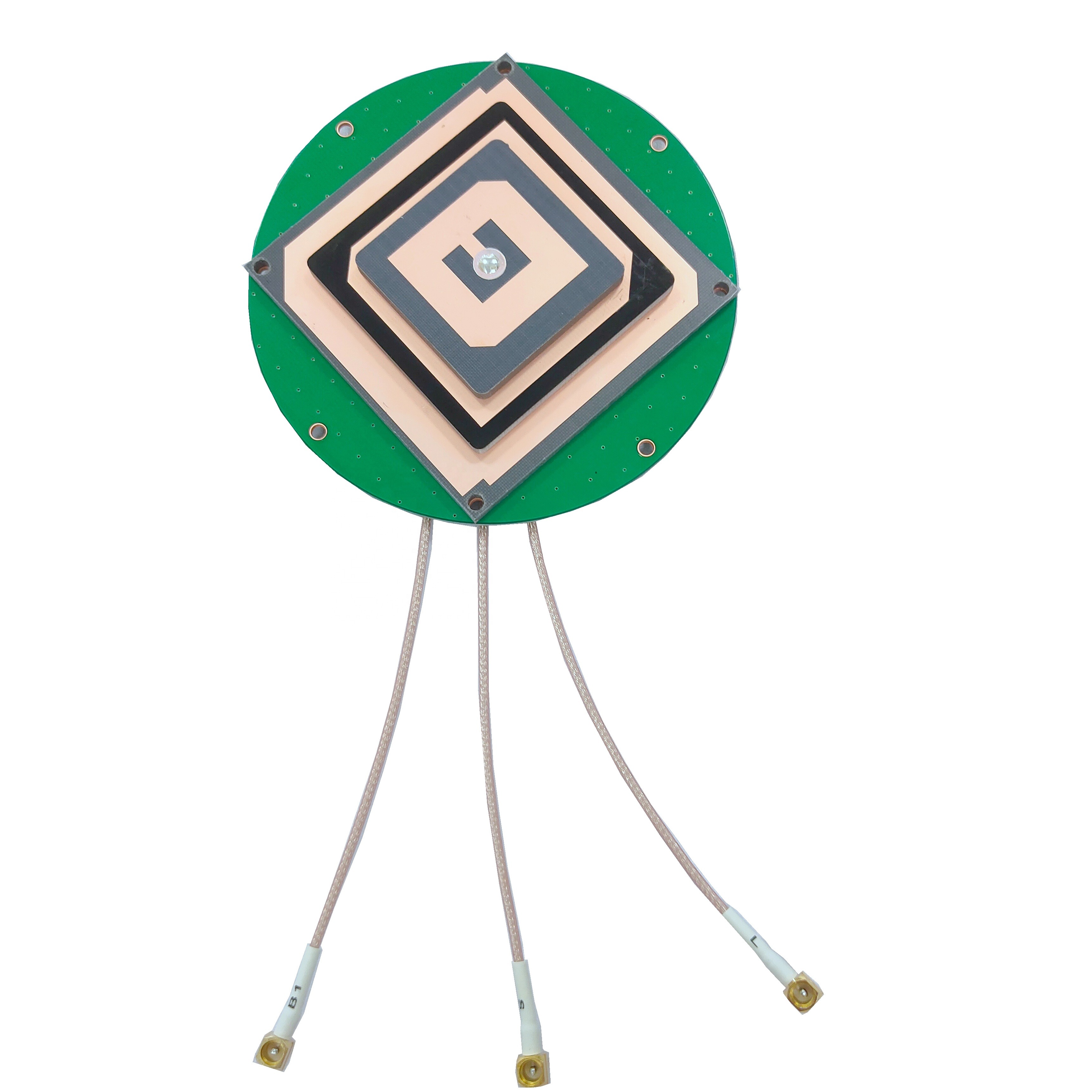
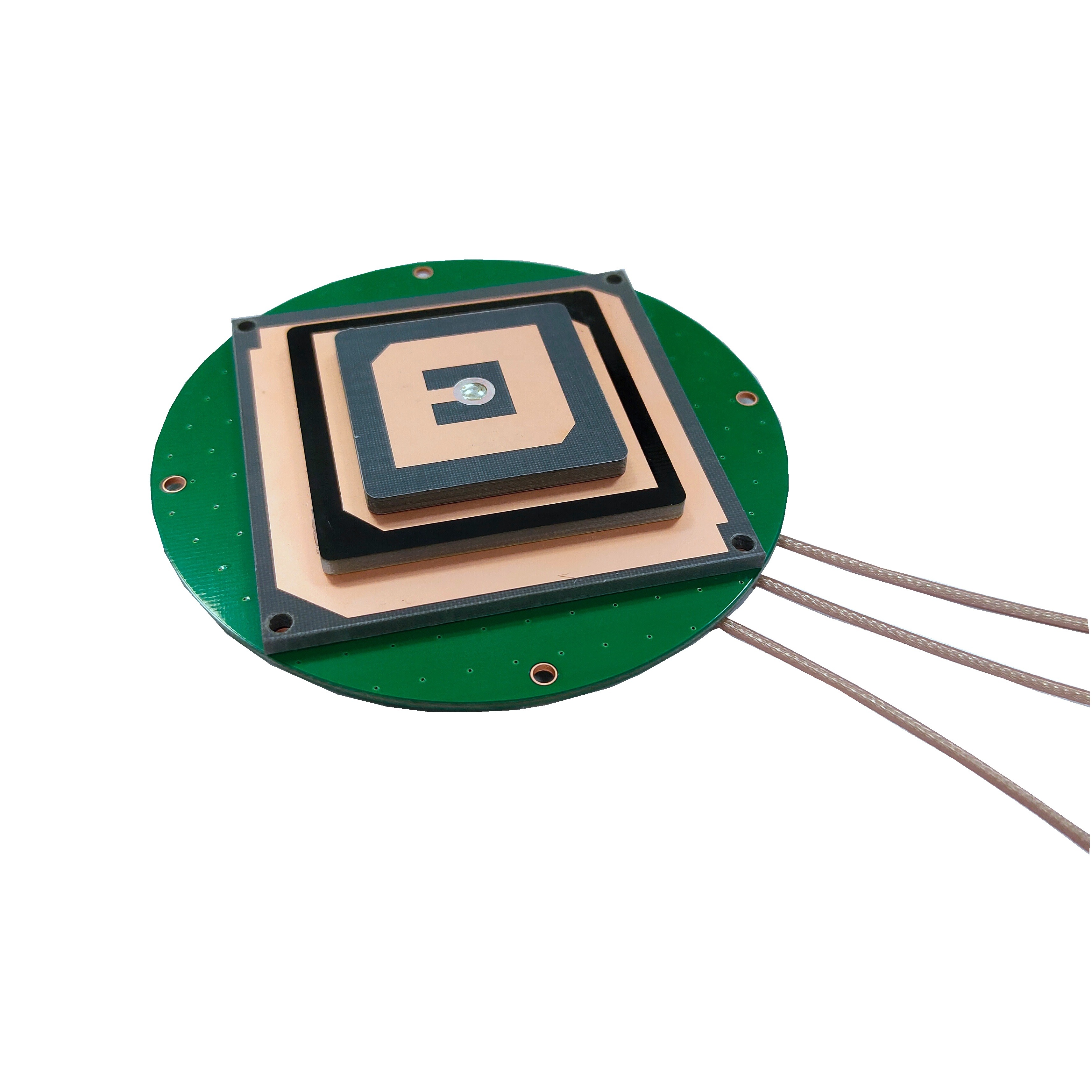
At the core of this antenna’s capability is its broad frequency coverage, encompassing GPS L1/L2, GLONASS G1/G2, Compass (BeiDou) B1/B2/B3, and Galileo E1/L1/E2/E5b/E6 bands. This multi-constellation support is foundational to modern surveying, where access to multiple satellite systems mitigates the risks of signal blockage, atmospheric interference, or satellite outages. For example, in urban canyons where GPS signals may be obstructed by buildings, the antenna’s ability to switch seamlessly to GLONASS or BeiDou signals ensures continuous positioning. Each frequency band serves a specific purpose: L1 (1575.42 MHz) and E1 (1575.42 MHz) are primary civilian bands for general positioning, while L2 (1227.60 MHz) and E5b (1176.45 MHz) offer enhanced precision through dual-frequency measurements that correct for ionospheric delays. The inclusion of BeiDou’s B3 band (1268.52 MHz) is particularly valuable for surveying in the Asia-Pacific region, where BeiDou’s regional constellation provides robust coverage. By supporting these bands, the antenna enables differential GNSS (DGNSS) and real-time kinematic (RTK) surveying techniques, which achieve accuracies of 1–5 centimeters—far beyond the capabilities of single-frequency, single-constellation systems.
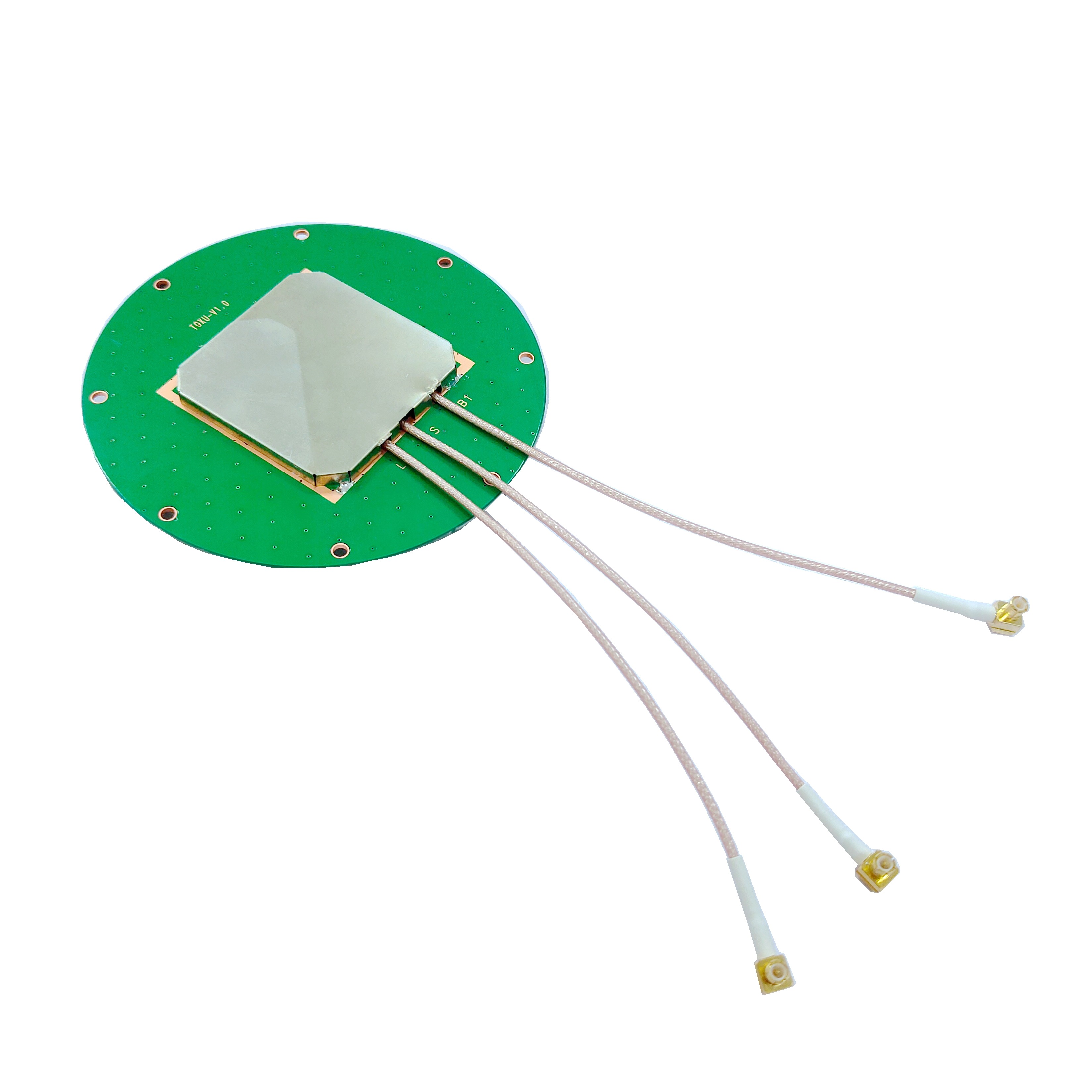
The physical dimensions of D146.5mm x 62.5mm reflect a deliberate balance between performance and practicality. Survey antennas must be large enough to accommodate multiple radiating elements—one for each frequency band—while remaining portable enough for field deployment. The 146.5mm diameter provides sufficient surface area for optimizing the radiation pattern, ensuring uniform sensitivity across all tracked frequencies. This size also allows for a robust ground plane, which minimizes interference from nearby objects and ensures that the antenna’s radiation pattern remains stable regardless of its orientation. The 62.5mm height is designed to house internal components such as low-noise amplifiers (LNAs) and bandpass filters without compromising the antenna’s center of gravity—a critical consideration when mounted on survey poles or tripods, where stability directly impacts measurement accuracy. Unlike compact UAV antennas, which prioritize miniaturization, survey antennas leverage their larger size to achieve superior signal-to-noise ratios and phase stability, both of which are essential for high-precision positioning.
An axial ratio of ≤3dB is a hallmark of the antenna’s circular polarization performance, a key factor in maintaining signal integrity from satellites. GNSS signals are circularly polarized, meaning their electric field rotates as they propagate. An antenna with a low axial ratio (ideally 0dB for perfect circular polarization) can efficiently receive these signals regardless of the satellite’s position in the sky. For surveying applications, where satellites may be low on the horizon (especially in mountainous or urban terrain), this is critical. A high axial ratio would cause signal attenuation for low-elevation satellites, reducing the number of usable signals and degrading positioning accuracy. By limiting the axial ratio to ≤3dB, the antenna ensures consistent reception across the entire sky, maximizing the number of tracked satellites and enabling more robust position solutions. This is particularly important for static surveying, where measurements are averaged over minutes or hours—even minor signal losses can accumulate, introducing errors into the final data.
The peak gain of ≥5dBi ensures that weak satellite signals are amplified sufficiently for precise processing. GNSS signals reach the Earth’s surface with power levels as low as -160 dBm, and survey antennas must capture these signals while minimizing noise. A gain of 5dBi provides a significant boost without introducing excessive noise, thanks to the antenna’s integrated LNAs, which typically have noise figures below 1dB. This combination of gain and low noise is especially valuable in challenging environments, such as dense forests or near electromagnetic interference (EMI) sources like power lines. In such scenarios, the antenna’s ability to amplify desired signals while rejecting noise ensures that even faint satellite signals can be used in positioning calculations. For dynamic surveying—such as mapping with a moving vehicle—the high gain helps maintain signal lock during rapid changes in satellite visibility, preventing data gaps that would require time-consuming re-surveys.
The 360° horizontal coverage angle is essential for the antenna’s omnidirectional performance, a requirement for surveying applications where the antenna’s orientation may vary. Unlike directional antennas, which focus reception in a specific direction, survey antennas must track satellites across the entire horizon. This is particularly important for static surveys, where the antenna is mounted on a tripod and left unattended for extended periods—satellites rise and set, and a 360° coverage angle ensures that none are missed. In dynamic applications, such as marine surveying or road mapping, the antenna must maintain coverage as the vehicle turns, pitches, or rolls. The omnidirectional pattern also simplifies field setup: surveyors do not need to precisely align the antenna with the sky, reducing setup time and minimizing human error. This feature, combined with the low axial ratio, ensures that the antenna performs consistently regardless of its orientation relative to the satellites.
A phase center error of ≤2mm is perhaps the most critical specification for survey antennas, as it directly impacts positioning accuracy. The phase center is the point within the antenna where the received signal’s phase is measured, and any variation in this point introduces errors into distance calculations from satellites. For surveying applications requiring millimeter-level precision—such as monitoring tectonic plate movement or structural deformation—even a 1mm error can render data useless. The antenna’s design minimizes phase center variation across frequencies and angles, ensuring that measurements are consistent regardless of which satellite signals are used. This stability is achieved through careful optimization of the radiating elements and feed networks, as well as rigorous calibration during manufacturing. Unlike consumer-grade antennas, which may have phase center errors of several centimeters, this antenna’s 2mm tolerance enables it to meet the stringent requirements of geodetic surveys and engineering projects.
The operating temperature range of -40°C to +85°C reflects the antenna’s ruggedness, a necessity for surveying in extreme environments. Survey teams operate in deserts, polar regions, and high-altitude mountain ranges, where temperatures can fluctuate dramatically. The antenna’s components—including its PCB, LNAs, and connectors—must withstand these extremes without degrading performance. For example, in sub-zero temperatures, the dielectric properties of the antenna’s substrate (typically a high-stability material like PTFE or ceramic) must remain consistent to avoid shifts in resonant frequency. In hot climates, the LNAs must operate within their thermal limits to prevent increased noise figures. The antenna’s enclosure, often made of UV-resistant plastic or aluminum, protects internal components from moisture, dust, and physical damage, ensuring that the phase center stability and gain specifications are maintained even after months of field use.
The screw mounting method provides a secure and repeatable way to attach the antenna to survey equipment. In surveying, the antenna’s position relative to the survey marker must be known with millimeter precision, and a screw mount ensures that the antenna can be attached and removed without altering its alignment. This is critical for static surveys, where the same antenna may be moved between multiple markers over several days. The mount’s design typically includes a reference point (such as a crosshair or notch) that aligns with the survey pole’s axis, ensuring that the antenna’s phase center is directly above the marker. Unlike adhesive mounts, which can shift over time, screw mounts provide a rigid connection that resists vibration and wind, maintaining alignment even in harsh weather conditions.
The MCX and TNC-K connectors offer flexibility in integrating the antenna with different survey receivers. TNC-K connectors are widely used in professional surveying equipment due to their robust mechanical design and excellent RF performance—they provide a secure, weatherproof connection that minimizes signal loss. MCX connectors, being smaller, are often used with portable receivers or data loggers, allowing for more compact setups. Both connectors are designed to maintain a consistent impedance (typically 50Ω) across the antenna’s frequency bands, ensuring that signal reflections are minimized. This is critical for preserving the integrity of the weak GNSS signals, as even minor impedance mismatches can introduce phase errors that degrade positioning accuracy. The availability of both connector types makes the antenna compatible with a wide range of surveying hardware, from high-end geodetic receivers to portable mapping systems.
The product name—“Factory price compass gps glonass antenna with TNC-K connector”—highlights its value proposition: professional-grade performance at an accessible cost. Surveying equipment is often a significant investment, and an affordable antenna that does not compromise on accuracy enables smaller firms and research teams to access high-precision positioning technology. The inclusion of BeiDou (Compass) support is particularly notable, reflecting the growing importance of China’s satellite constellation in global surveying. For projects in regions with strong BeiDou coverage, such as Asia, Africa, and Europe, this antenna leverages the constellation’s high number of satellites to improve positioning redundancy and accuracy. The factory pricing model suggests direct distribution, reducing costs by eliminating middlemen and making high-performance surveying technology more accessible.
Beyond these specifications, the antenna’s design incorporates several advanced features to enhance surveying performance. For example, it likely includes built-in bandpass filters to reject interference from sources like cellular towers, which operate in frequencies adjacent to GNSS bands. This is critical in urban or industrial areas, where EMI can corrupt satellite signals. The antenna may also use choke rings—concentric metal rings around the base—to reduce multipath interference, which occurs when signals reflect off nearby surfaces (such as buildings or the ground) before reaching the antenna. Multipath is a major source of error in surveying, and choke rings mitigate this by absorbing reflected signals, ensuring that only direct signals from satellites are used in positioning calculations.
In static surveying applications, where the antenna remains stationary for hours, the antenna’s low power consumption is an important consideration. The integrated LNAs are designed to operate efficiently, drawing minimal current from the survey receiver’s battery. This extends field operation time, reducing the need for frequent battery changes and ensuring that long-duration surveys can be completed without interruption. For dynamic surveying, such as mapping a road network, the antenna’s lightweight design (facilitated by its optimized size and materials) reduces strain on mounting equipment, making it easier to handle during extended fieldwork.
Calibration is another key aspect of the antenna’s performance. Reputable manufacturers provide detailed calibration charts that document the antenna’s phase center variations across frequencies and angles. Survey software uses these charts to correct raw measurements, ensuring that the final positioning data accounts for any residual phase center errors. This level of calibration is unique to professional survey antennas and is what distinguishes them from consumer-grade alternatives, which lack such detailed characterization.
The antenna’s compliance with industry standards is also worth noting. It likely meets specifications set by organizations like the International GNSS Service (IGS), which defines performance criteria for geodetic antennas. Compliance with these standards ensures that the antenna can be used in international projects, where data compatibility between different survey teams is essential. For example, in cross-border infrastructure projects, such as highway or pipeline construction, using IGS-compliant antennas ensures that measurements from adjacent teams are consistent, avoiding costly discrepancies during project integration.
In conclusion, the GNSS survey antenna’s technical specifications are a testament to the engineering required to achieve centimeter-level positioning in diverse field conditions. From its multi-constellation frequency support and low phase center error to its rugged design and flexible mounting options, every parameter is optimized for the demands of professional surveying. As surveying applications continue to expand—from smart city development to climate change research—the role of high-performance GNSS antennas becomes increasingly critical. This antenna, with its balance of accuracy, reliability, and affordability, enables surveyors to collect precise data that forms the foundation of informed decision-making in countless industries. Whether deployed in remote wilderness areas or bustling urban centers, it stands as a vital tool in the quest to map and measure our world with unprecedented precision.

 86 0755 2819 9597
Lucy Yang | lucy.y@toxutech.com
Nicole Li | nicole@toxutech.com
Dotty Zhao | sales04@toxutech.com
Global Business Director / Sales Team / Global Operations


 En
En Cn
Cn Korean
 Home >


