

-
Products -PCBA Manufacturing RF Connectors RF Cable Assemblys Embedded Antennas External Antennas Positioning Chips and Modules
RF Connectors

RF Cable Assemblys
Embedded Antennas
External Antennas
Positioning Chips and Modules


 Language


Language


In the dynamic landscape of geospatial technology, Compact Surveying GNSS Antennas have emerged as indispensable tools, playing a pivotal role in a wide array of applications. These antennas are designed to receive signals from Global Navigation Satellite Systems (GNSS), which include well - known constellations such as GPS (Global Positioning System), GLONASS (Globalnaya Navigatsionnaya Sputnikovaya Sistema), Galileo, and BeiDou, among others.
The significance of Compact Surveying GNSS Antennas lies in their ability to provide highly accurate positioning data. In surveying and mapping applications, centimeter - level accuracy is often required to precisely define boundaries, create detailed topographic maps, and monitor changes in the Earth's surface over time. For example, in land surveying for urban development projects, these antennas enable surveyors to accurately mark property lines, ensuring legal compliance and proper planning.
The demand for such antennas has been steadily increasing due to the growth of various industries. In the construction industry, they are used for site layout, ensuring that buildings and infrastructure are erected in the correct positions. Precision agriculture also benefits greatly from Compact Surveying GNSS Antennas, as farmers can use them to precisely map their fields, optimize the use of fertilizers and water, and improve crop yields. Additionally, in the field of environmental monitoring, these antennas help in tracking the movement of glaciers, measuring land subsidence, and monitoring coastal erosion.
The evolution of Compact Surveying GNSS Antennas has been remarkable. Early GNSS antennas were large, bulky, and had limited capabilities. They could only receive signals from a single constellation, typically GPS, and their accuracy was relatively low. However, with advancements in technology, modern antennas are now much smaller, more lightweight, and capable of receiving signals from multiple constellations simultaneously. This multi - constellation reception significantly improves signal availability and accuracy, especially in challenging environments such as urban canyons or dense forests, where signals from a single constellation may be blocked or weakened.
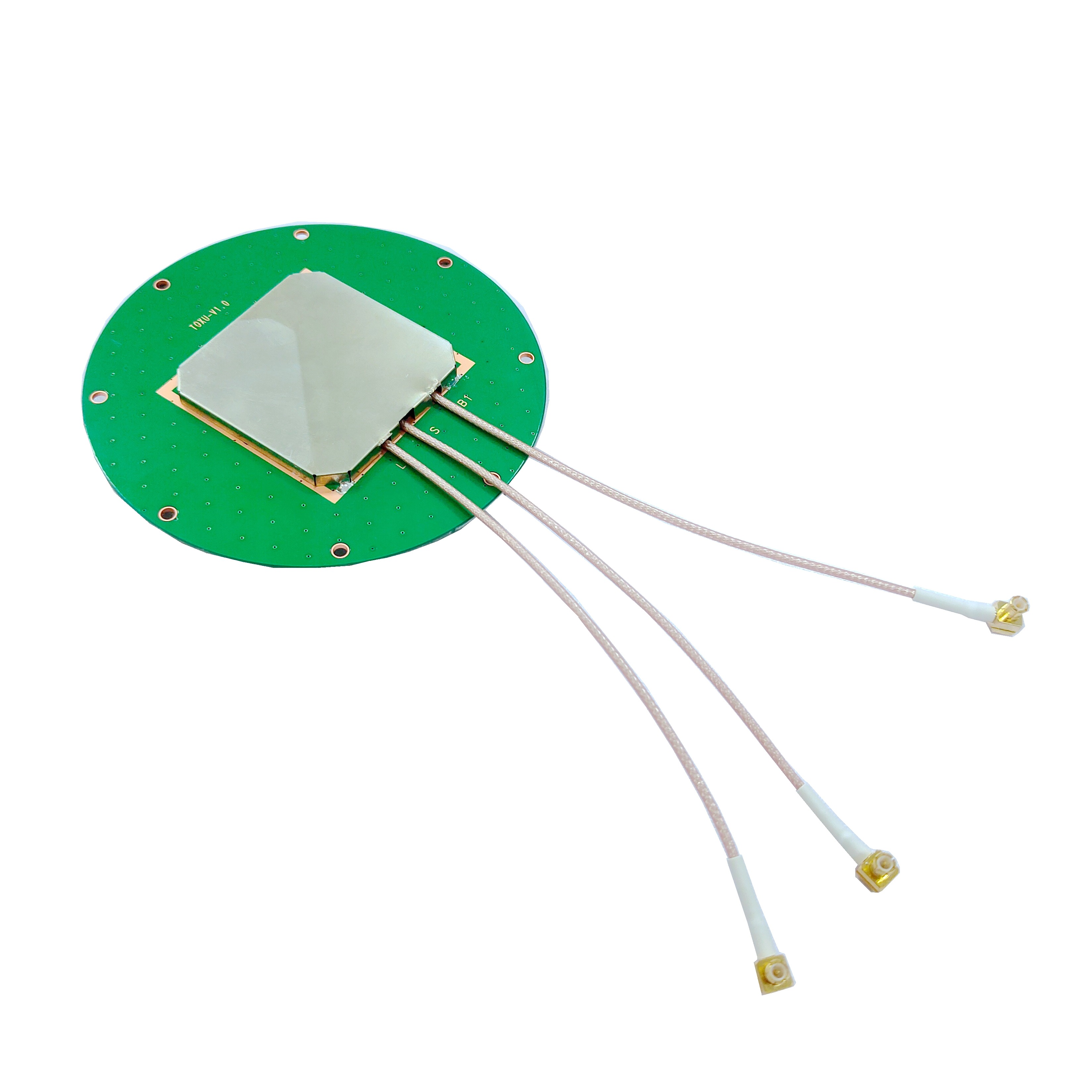
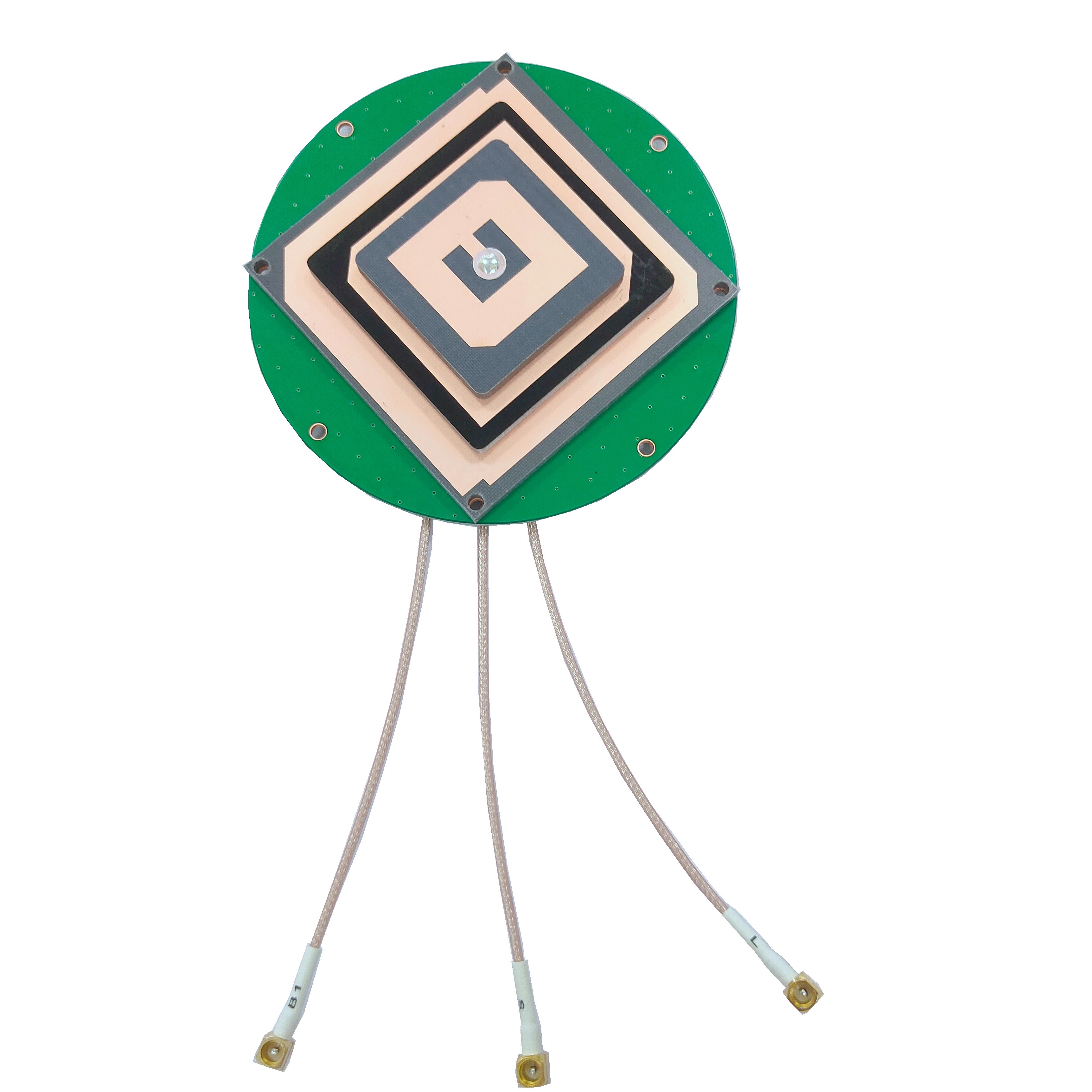
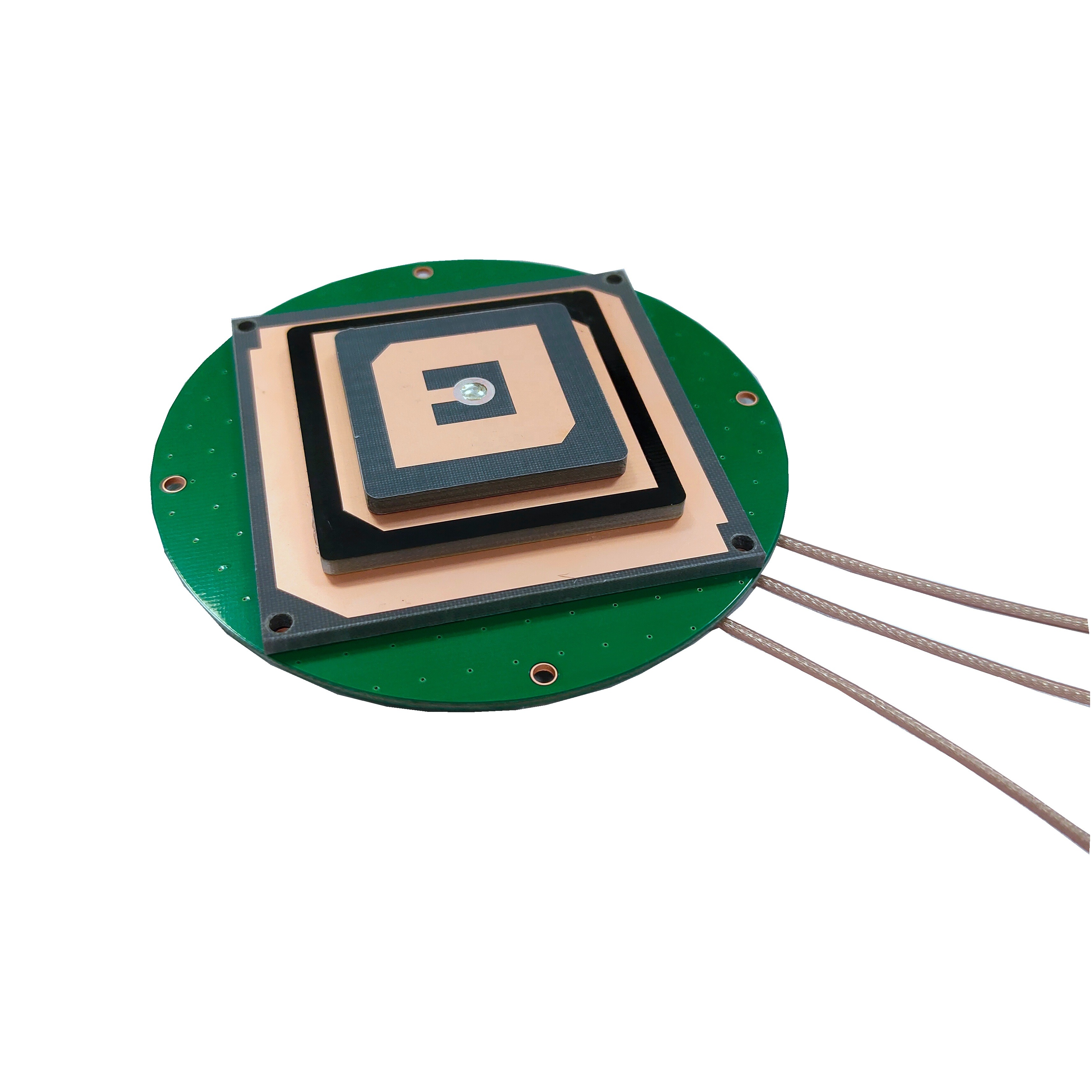
2.1 Structural Design
Compact Surveying GNSS Antennas are engineered with a focus on optimizing performance while minimizing size and weight. The structural design typically consists of a baseplate, a radome, and the antenna elements themselves.
The baseplate serves as the foundation of the antenna, providing stability and a means of attachment to various mounting surfaces. It is often made of a rigid material, such as metal or high - strength plastic, to ensure that the antenna remains firmly in place during operation. In some cases, the baseplate may be designed with specific features, such as leveling screws or a quick - release mechanism, to facilitate easy installation and adjustment in the field.
The radome, which encloses the antenna elements, plays a crucial role in protecting them from environmental factors such as moisture, dust, and mechanical damage. It is made of a dielectric material that is transparent to GNSS signals, allowing the signals to pass through with minimal attenuation. The shape of the radome is carefully designed to minimize signal reflections and diffraction, which could otherwise degrade the antenna's performance. For example, a hemispherical radome is a common design choice as it provides a wide field of view for signal reception while reducing the likelihood of signal interference.
2.2 Antenna Elements
The antenna elements are the core components responsible for receiving GNSS signals. There are several types of antenna elements commonly used in Compact Surveying GNSS Antennas, each with its own advantages and characteristics.
One of the most widely used types is the patch antenna. Patch antennas are planar in design, which makes them compact and lightweight. They consist of a conductive patch printed on a dielectric substrate, with a ground plane on the opposite side. Patch antennas are known for their relatively low - cost production, ease of integration into different systems, and good performance in terms of gain and radiation pattern. They can be designed to operate at specific frequencies corresponding to the signals transmitted by GNSS satellites.
Another type is the helical antenna. Helical antennas are characterized by their spiral - shaped structure. They offer high gain, especially in the axial direction, which makes them suitable for applications where long - range signal reception is required. Helical antennas are often used in scenarios where the antenna needs to receive signals from satellites at low elevation angles, as they can provide better performance in such conditions compared to some other antenna types.
In addition to these, there are also dipole antennas and quadrifilar helix antennas (QHA) used in GNSS applications. Dipole antennas are simple in design, consisting of two conductive elements, and are known for their linear polarization characteristics. QHA antennas, on the other hand, combine the advantages of helical and dipole antennas, offering circular polarization and good performance in terms of signal reception and interference rejection.
2.3 Material Selection
The choice of materials in the construction of Compact Surveying GNSS Antennas is critical to ensure optimal performance and durability.
For the antenna elements, conductive materials with low resistivity are preferred. Copper and aluminum are commonly used due to their excellent electrical conductivity. These materials allow for efficient transmission and reception of electrical signals, which is essential for capturing weak GNSS signals from satellites. In some high - end antennas, gold - plated elements may be used to further reduce resistance and improve signal integrity, especially in applications where the highest level of accuracy is required.
The dielectric materials used in the construction of the radome and the substrate of patch antennas are carefully selected based on their electrical properties. Dielectric materials with a low dielectric constant and low loss tangent are desirable as they minimize signal attenuation and distortion. Materials such as Teflon, fiberglass - reinforced plastics, and certain ceramic materials are often used for their excellent dielectric properties. These materials also provide good mechanical strength and resistance to environmental factors, ensuring the long - term reliability of the antenna.
The baseplate and other structural components are typically made of materials that offer a good balance of strength, lightweight, and corrosion resistance. Aluminum alloys are a popular choice as they are lightweight yet strong enough to support the antenna and withstand mechanical stress. In harsh environments, such as those near the ocean or in industrial areas with high levels of pollution, corrosion - resistant materials like stainless steel or composite materials may be used to prevent degradation of the antenna's structure over time.
3.1 Signal Reception
Compact Surveying GNSS Antennas operate by receiving signals transmitted by GNSS satellites orbiting the Earth. These satellites continuously broadcast signals that contain information about their position in space and the time at which the signal was transmitted.
When a GNSS signal reaches the antenna, it induces an electrical current in the antenna elements. The design of the antenna elements is optimized to capture these weak signals, which have extremely low power levels by the time they reach the Earth's surface. The electrical current induced in the antenna elements is then converted into an electrical signal that can be processed by the GNSS receiver.
The antenna's ability to receive signals from multiple satellites simultaneously is a key feature. By receiving signals from at least four satellites, the GNSS receiver can use a process called trilateration to calculate its position on the Earth's surface. Each satellite's signal provides information about the distance between the satellite and the receiver, based on the time it takes for the signal to travel from the satellite to the receiver. The receiver then uses this distance information from multiple satellites to triangulate its position in three - dimensional space (latitude, longitude, and altitude).
3.2 Signal Processing
Once the GNSS signals are received by the antenna and converted into electrical signals, they are sent to the GNSS receiver for processing. The receiver's main task is to extract the relevant information from the signals, such as the satellite's position and the time of signal transmission.
The first step in signal processing is signal amplification. The weak signals received by the antenna are amplified to a level that can be more easily processed by the receiver's electronics. This is typically done using low - noise amplifiers (LNAs) to minimize the introduction of additional noise, which could degrade the signal - to - noise ratio and affect the accuracy of the position calculation.
After amplification, the signals are filtered to remove unwanted noise and interference. GNSS signals are susceptible to interference from various sources, such as nearby electronic devices, radio transmitters, and multipath reflections (where the signal bounces off buildings or other objects before reaching the antenna). The receiver uses a combination of analog and digital filters to isolate the desired GNSS signals and reject interference.
The next step is signal demodulation, where the information carried by the GNSS signals is extracted. GNSS signals are modulated using a specific code, such as the Code - Division Multiple Access (CDMA) code. The receiver correlates the received signal with a locally generated copy of the code to recover the original information, which includes the satellite's ephemeris (its orbit information), clock correction data, and other navigation - related parameters.
Finally, the receiver uses this information to calculate its position. The position calculation is based on the principles of trilateration or, more commonly, a more advanced technique called carrier - phase ranging. Carrier - phase ranging can achieve centimeter - level accuracy by measuring the phase of the carrier signal of the GNSS signal, in addition to the code - based ranging. This requires highly stable antennas and receivers, as even small changes in the phase center of the antenna or the receiver's clock can affect the accuracy of the position calculation.
3.3 Phase Center and Accuracy
The phase center of a Compact Surveying GNSS Antenna is a crucial concept related to its accuracy. The phase center is the point in space from which the antenna appears to radiate or receive signals in an ideal, spherical - wave pattern. In reality, the phase center of an antenna can vary depending on factors such as the frequency of the signal, the direction of the incoming signal, and the antenna's design.
A stable phase center is essential for achieving high - accuracy positioning. If the phase center of the antenna moves or changes with respect to the physical center of the antenna, it can introduce errors in the position calculation. For example, in a differential GNSS (DGNSS) or Real - Time Kinematic (RTK) surveying setup, where the position of a rover antenna is determined relative to a base station antenna, any variation in the phase center of either antenna can lead to inaccurate relative position measurements.
Manufacturers of Compact Surveying GNSS Antennas take great care to design antennas with minimal phase center variation. This may involve using advanced manufacturing techniques, precise calibration procedures, and innovative antenna designs. Some antennas are also equipped with calibration data that can be used by the GNSS receiver to correct for any known phase center variations, further improving the accuracy of the position calculation. In high - precision surveying applications, such as geodetic control surveys or deformation monitoring, the stability of the antenna's phase center can make the difference between achieving centimeter - level accuracy and having significant errors in the measured positions.
4.1 Advantages
4.1.1 High Accuracy
One of the most significant advantages of Compact Surveying GNSS Antennas is their ability to provide high - accuracy positioning data. In modern surveying applications, centimeter - level accuracy is often required, and these antennas, when used in conjunction with advanced GNSS receivers and techniques such as RTK, can easily achieve this. For example, in large - scale construction projects, accurate positioning of construction equipment is crucial to ensure that structures are built according to design specifications. Compact Surveying GNSS Antennas enable real - time monitoring of the position of bulldozers, excavators, and other machinery, allowing for precise grading and earthmoving operations. In geodetic surveys, where the goal is to accurately measure the shape and size of the Earth or to monitor tectonic plate movements, the high accuracy of these antennas is essential for obtaining reliable data.
4.1.2 Compact and Lightweight Design
The compact and lightweight nature of these antennas is a major advantage, especially in field applications where portability is key. Surveyors often need to carry their equipment over long distances and work in remote or difficult - to - access locations. A lightweight antenna reduces operator fatigue and makes it easier to set up and move the surveying equipment. For instance, in forestry surveys, where surveyors may need to traverse through dense vegetation, a compact and lightweight GNSS antenna can be easily attached to a backpack or carried on a pole, allowing for efficient data collection. In addition, the small size of these antennas makes them suitable for integration into smaller devices, such as unmanned aerial vehicles (UAVs) or handheld surveying instruments, expanding their range of applications.
4.1.3 Multi - Constellation Compatibility
Modern Compact Surveying GNSS Antennas are designed to be compatible with multiple satellite constellations, including GPS, GLONASS, Galileo, and BeiDou. This multi - constellation compatibility significantly improves signal availability and accuracy. In areas with challenging terrain or in urban environments, where signals from a single constellation may be blocked or weakened, the ability to receive signals from multiple constellations ensures that the antenna can still obtain a reliable position fix. For example, in a city with tall buildings, GPS signals may be frequently obstructed, but by also receiving signals from GLONASS and Galileo satellites, the antenna can maintain continuous tracking and accurate positioning. This multi - constellation support also enhances the redundancy of the GNSS system, making it more robust and reliable for critical applications such as precision agriculture, where accurate positioning is necessary for optimal crop management.
4.2 Challenges
4.2.1 Signal Interference
Signal interference is a major challenge faced by Compact Surveying GNSS Antennas. GNSS signals are relatively weak by the time they reach the Earth's surface, and they can be easily disrupted by various sources of interference. One common source of interference is nearby electronic devices, such as mobile phones, Wi - Fi routers, and radio transmitters. These devices operate in frequency bands that may overlap with the GNSS frequencies, causing signal jamming or distortion. In addition, multipath interference is a significant problem, especially in urban areas or near large bodies of water. Multipath occurs when the GNSS signal bounces off buildings, terrain, or other objects before reaching the antenna, creating multiple versions of the signal that can interfere with each other and lead to inaccurate position calculations. To mitigate signal interference, antenna manufacturers often incorporate advanced filtering techniques and shielding in their designs, and users may need to carefully select the location of the antenna to minimize exposure to potential interference sources.
4.2.2 Environmental Sensitivity
Compact Surveying GNSS Antennas are sensitive to environmental conditions, which can affect their performance. Extreme temperatures, high humidity, and heavy rainfall can all impact the antenna's ability to receive signals accurately. For example, in very cold temperatures, the electrical properties of the antenna materials may change, leading to increased signal attenuation. In humid environments, moisture can accumulate inside the radome, causing signal reflections and degradation. Additionally, strong winds can cause the antenna to move or vibrate, which may affect the stability of the phase center and introduce errors in the position calculation. To address these environmental challenges, antennas are often designed with ruggedized enclosures and materials that are resistant to temperature variations and moisture. However, in some extreme environmental conditions, additional measures such as heating or cooling systems for the antenna may be required to ensure reliable operation.
4.2.3 Cost - Performance Trade - off
There is often a cost - performance trade - off associated with Compact Surveying GNSS Antennas. High - end antennas that offer the highest level of accuracy, multi - constellation support, and advanced features such as low - phase - center variation and excellent interference rejection can be relatively expensive. This cost can be a barrier for some users, especially those in small - scale or budget - constrained projects. On the other hand, more affordable antennas may sacrifice some performance features, such as accuracy or the ability to receive signals from all available constellations. Striking the right balance between cost and performance is a challenge for both antenna manufacturers and users. Manufacturers need to develop antennas that offer good performance at a reasonable cost, while users need to carefully evaluate their requirements and select an antenna that meets their needs without overspending. In some cases, users may need to consider alternative solutions, such as using a combination of lower - cost antennas with additional post - processing techniques to achieve acceptable accuracy levels.
5.1 Current Applications
5.1.1 Geospatial Surveying and Mapping
Compact Surveying GNSS Antennas are extensively used in geospatial surveying and mapping applications. In land surveying, they are used to accurately measure property boundaries, create detailed topographic maps, and establish control points for construction projects. For example, when surveying a large tract of land for a new housing development, surveyors use these antennas to precisely mark the corners of each lot, ensuring that the land is divided correctly and that the construction of houses and infrastructure adheres to local regulations. In mapping applications, GNSS - equipped drones with Compact Surveying GNSS Antennas are increasingly being used to capture high - resolution elevation data and create 3D maps of large areas. These maps are valuable for a wide range of purposes, including urban planning, environmental monitoring, and disaster management.
5.1.2 Precision Agriculture
The agricultural industry has seen a significant adoption of Compact Surveying GNSS Antennas in recent years. Precision agriculture techniques rely on accurate positioning data to optimize various farming operations. With the help of these antennas, farmers can precisely map their fields, identify areas with different soil characteristics, and apply fertilizers, pesticides, and water more efficiently. For instance, variable - rate application systems, which use GNSS - guided equipment, can adjust the amount of inputs based on the specific needs of each part of the field, reducing waste and increasing crop yields. In addition, GNSS - enabled tractors and other agricultural machinery can be automated to follow precise paths, improving the accuracy of planting, tilling, and harvesting operations.
5.1.3 Construction and Infrastructure Projects
In the construction and infrastructure sectors, Compact Surveying GNSS Antennas play a crucial role in ensuring the accurate placement of buildings, roads, bridges, and other structures. During the construction process, surveyors use these antennas to set out the positions of foundation markers, check the alignment of structural elements, and monitor the progress of the project. For large - scale infrastructure projects such as highway construction, GNSS - based systems can be used to guide earthmoving equipment, ensuring that the terrain is graded to the correct specifications. In addition, these antennas are used for deformation monitoring of buildings and bridges over time, allowing for early detection of any structural issues and ensuring the safety of the infrastructure.
5.2 Future Trends
5.2.1 Integration with Other Technologies
One of the major future trends for Compact Surveying GNSS Antennas is their deep integration with other cutting-edge technologies, which will further expand their application scope and enhance overall performance.
The integration with LiDAR (Light Detection and Ranging) technology is particularly promising. LiDAR systems excel at capturing high-resolution 3D point clouds of the surrounding environment, while Compact Surveying GNSS Antennas provide precise positional data. By combining these two technologies, users can obtain both accurate spatial coordinates and detailed environmental features simultaneously. For example, in urban mapping projects, a LiDAR-equipped vehicle with a Compact Surveying GNSS Antenna can collect 3D data of buildings, roads, and vegetation, with each point in the LiDAR point cloud tagged with precise GNSS coordinates. This integrated solution eliminates the need for separate data collection and post-processing steps, significantly improving efficiency and reducing errors. In addition, in forestry inventory surveys, the combined system can accurately measure tree heights, diameters, and positions, providing comprehensive data for forest management and ecological research.
Another key integration trend is with Inertial Measurement Units (IMUs). IMUs consist of accelerometers and gyroscopes that can measure the acceleration and angular velocity of a moving object. When integrated with Compact Surveying GNSS Antennas, IMUs can fill in the gaps in GNSS signal reception during short-term signal outages, such as when the antenna passes through a tunnel, under a dense forest canopy, or in an urban canyon with tall buildings blocking satellite signals. For instance, in autonomous driving applications for construction vehicles, the integrated GNSS-IMU system ensures that the vehicle maintains accurate positioning even when GNSS signals are temporarily lost, preventing accidents and ensuring the vehicle follows the planned path. In marine surveying, where GNSS signals may be disrupted by waves or weather conditions, the IMU integration provides continuous positioning data, ensuring the accuracy of hydrographic maps and underwater structure surveys.
Furthermore, the integration with Internet of Things (IoT) platforms is set to revolutionize the way Compact Surveying GNSS Antennas are used. IoT-enabled antennas can transmit positioning data in real-time to a central cloud platform, where the data can be analyzed, visualized, and shared among multiple users. In precision agriculture, for example, a network of IoT-connected Compact Surveying GNSS Antennas installed on farm equipment can send real-time positioning and operational data to a farmer’s dashboard. The farmer can then monitor the progress of farming operations, adjust input application rates remotely, and make data-driven decisions to optimize crop yields. In smart city projects, IoT-integrated antennas can provide real-time data on the movement of public transportation, the condition of infrastructure, and the flow of pedestrians, enabling city planners to improve traffic management, enhance public safety, and reduce energy consumption.
5.2.2 Enhanced Performance and Miniaturization
As technology continues to advance, Compact Surveying GNSS Antennas will see significant improvements in performance, with a particular focus on increasing accuracy, reducing power consumption, and achieving further miniaturization.
In terms of accuracy, future antennas will leverage advanced signal processing algorithms and multi-frequency reception to achieve sub-centimeter-level accuracy. Multi-frequency reception allows the antenna to receive signals from multiple frequency bands of GNSS constellations, which helps to reduce errors caused by ionospheric and tropospheric delays. For example, modern GNSS constellations such as Galileo and BeiDou transmit signals in multiple frequency bands, and future Compact Surveying GNSS Antennas will be designed to receive these signals simultaneously. By processing data from multiple frequencies, the antenna can more accurately correct for atmospheric errors, resulting in higher positioning accuracy. This level of accuracy will be particularly valuable in applications such as geodetic surveys, where precise measurements of the Earth’s crustal movements are essential for studying tectonic activity and predicting natural disasters.
Power consumption is another critical area for improvement. Many field applications of Compact Surveying GNSS Antennas, such as environmental monitoring in remote areas or wildlife tracking, rely on battery power. Reducing the power consumption of the antenna will extend the battery life of the device, allowing for longer periods of operation without the need for recharging or battery replacement. Future antennas will incorporate low-power electronics, such as energy-efficient amplifiers and signal processors, and will use advanced power management techniques to minimize power usage during idle periods. For example, the antenna can automatically enter a low-power mode when it is not actively receiving signals, and wake up quickly when signals are detected. This will be especially beneficial for IoT-connected antennas, which may be deployed in remote locations where access to power is limited.
Miniaturization is also a key trend, with future Compact Surveying GNSS Antennas becoming even smaller and lighter. This will enable their integration into a wider range of devices, including wearable technology, small UAVs, and micro-robots. For instance, miniaturized antennas can be embedded in smartwatches or fitness trackers used by surveyors, allowing them to track their own position while collecting data in the field. In the case of small UAVs, smaller and lighter antennas will reduce the weight of the drone, increasing its flight time and payload capacity. This will make it possible to use UAVs for more extensive surveying missions, such as mapping large areas of land or inspecting tall structures. Advanced manufacturing techniques, such as 3D printing and microelectromechanical systems (MEMS) technology, will play a crucial role in achieving this miniaturization. 3D printing allows for the creation of complex antenna structures with precise dimensions, while MEMS technology enables the fabrication of tiny electronic components that can be integrated into the antenna design.
5.2.3 Artificial Intelligence (AI) and Machine Learning (ML) Integration
The integration of Artificial Intelligence (AI) and Machine Learning (ML) algorithms into Compact Surveying GNSS Antennas is set to transform their capabilities, enabling them to adapt to changing environments, improve signal processing, and provide more intelligent insights.
AI and ML algorithms can be used to enhance signal processing by automatically identifying and mitigating interference. Traditional interference mitigation techniques rely on predefined filters and rules, which may not be effective against new or unknown sources of interference. AI-powered antennas, on the other hand, can learn from historical data to recognize patterns of interference and develop adaptive filtering strategies. For example, the antenna can use ML algorithms to analyze the characteristics of incoming signals, distinguish between legitimate GNSS signals and interference, and apply the appropriate filtering techniques to reject the interference. This will be particularly useful in urban environments, where the number of potential interference sources is constantly increasing, and in military applications, where intentional jamming is a significant threat.
In addition, AI and ML can be used to improve the accuracy of position calculations by correcting for errors caused by environmental factors. For instance, ML algorithms can analyze data on atmospheric conditions, such as temperature, humidity, and pressure, and use this information to more accurately model and correct for ionospheric and tropospheric delays. The algorithms can also learn from past positioning errors in specific locations and adjust the position calculation accordingly. This adaptive error correction will result in more consistent and reliable positioning data, even in challenging environments.
Furthermore, AI-powered Compact Surveying GNSS Antennas can provide intelligent insights by analyzing the positioning data they collect. For example, in construction projects, the antenna can track the movement of construction equipment and use AI algorithms to identify inefficiencies in the construction process, such as equipment idle time or unnecessary movements. The antenna can then provide recommendations to optimize the workflow, reducing costs and improving productivity. In environmental monitoring, the antenna can collect data on the movement of glaciers or the spread of wildfires and use ML algorithms to predict future changes, enabling early warning systems and more effective disaster response.
Compact Surveying GNSS Antennas have evolved from simple, single-constellation receivers to sophisticated, multi-functional tools that are essential in a wide range of industries, including geospatial surveying, precision agriculture, construction, and environmental monitoring. Their ability to provide high-accuracy positioning data, combined with their compact and lightweight design, has made them indispensable for field applications where portability and reliability are critical.
Throughout this analysis, we have explored the key aspects of Compact Surveying GNSS Antennas, from their overview and design to their working principles, advantages, challenges, applications, and future trends. The overview highlighted the growing demand for these antennas driven by the expansion of industries that require precise positioning, while the design and construction section detailed the structural components, antenna elements, and material selection that contribute to their performance and durability. The working principles section explained how these antennas receive and process GNSS signals to calculate accurate positions, emphasizing the importance of the phase center in achieving high accuracy.
The advantages of Compact Surveying GNSS Antennas, including their high accuracy, compact design, and multi-constellation compatibility, have enabled significant advancements in various fields. However, they also face challenges such as signal interference, environmental sensitivity, and cost-performance trade-offs, which require ongoing innovation to address. The current applications section demonstrated how these antennas are being used to improve efficiency and accuracy in geospatial surveying, precision agriculture, and construction, while the future trends section outlined the potential for integration with other technologies, enhanced performance, and AI-powered capabilities.
Looking ahead, the future of Compact Surveying GNSS Antennas is bright, with continued advancements in technology expected to further expand their capabilities and application scope. The integration with LiDAR, IMUs, and IoT platforms will enable more comprehensive and efficient data collection, while enhancements in performance and miniaturization will allow for integration into even smaller and more diverse devices. The integration of AI and ML algorithms will transform these antennas from passive data receivers to active, intelligent tools that can adapt to changing environments and provide valuable insights.
In conclusion, Compact Surveying GNSS Antennas will continue to play a crucial role in shaping the future of geospatial technology and related industries. As they become more advanced, reliable, and accessible, they will enable new applications and innovations that we can only begin to imagine. Whether it is improving the accuracy of construction projects, optimizing agricultural practices, or monitoring the health of our planet, Compact Surveying GNSS Antennas will remain at the forefront of precision positioning technology, driving progress and innovation for years to come.

 86 0755 2819 9597
Lucy Yang | lucy.y@toxutech.com
Nicole Li | nicole@toxutech.com
Dotty Zhao | sales04@toxutech.com
Global Business Director / Sales Team / Global Operations


 En
En Cn
Cn Korean
 Home >


