

-
Products -PCBA Manufacturing RF Connectors RF Cable Assemblys Embedded Antennas External Antennas Positioning Chips and Modules
RF Connectors

RF Cable Assemblys
Embedded Antennas
External Antennas
Positioning Chips and Modules


 Language


Language


The Compact Real-Time Kinematic (RTK) Combination Antenna represents a pivotal technological convergence in the fields of high-precision positioning and navigation. To understand its significance, one must first dissect its name: "Compact" refers to its small form factor, designed for integration into mobile and space-constrained applications; "RTK" denotes its primary purpose—to enable Real-Time Kinematic positioning, a technique that provides centimeter-level accuracy; and "Combination" is the key innovation, indicating the seamless integration of a high-performance Global Navigation Satellite System (GNSS) antenna with a robust data link antenna (typically for cellular or radio communications) into a single, unified housing.
For decades, achieving high-precision GNSS positioning required a complex setup: a survey-grade GNSS antenna mounted on a pole, connected via a long cable to a separate receiver unit, which itself needed a second antenna and modem for receiving correction data. This setup was cumbersome, prone to cable damage and signal loss, and impractical for burgeoning applications like autonomous drones, agricultural robotics, and wearable technology. The Compact RTK Combination Antenna elegantly solves this problem by merging all critical RF components into one portable, ruggedized device. It is the fundamental sensor that empowers a new generation of intelligent machines to understand their position on Earth with unprecedented accuracy and reliability.
At its core, the antenna performs two simultaneous and critical functions:
GNSS Reception: It receives extremely weak signals from multiple satellite constellations (GPS, GLONASS, Galileo, BeiDou, etc.) orbiting over 20,000 kilometers away. This requires a highly sensitive and phase-stable antenna element.
Correction Data Reception/Transmission: It transmits its raw GNSS observation data and/or receives real-time correction data from a base station or network via a built-in cellular (4G/LTE, 5G) or UHF radio link antenna.
The integration of these two antennas is non-trivial. A primary engineering challenge is preventing interference between the powerful outgoing transmission from the data link and the incredibly faint incoming signals from the GNSS satellites. Sophisticated filtering, careful component placement, and advanced materials are used to ensure both systems operate harmoniously without degrading the precious GNSS signal quality, which is the very foundation of RTK accuracy.
The market driver for this technology is the explosive growth of autonomy and automation. From precision agriculture, where tractors must navigate within centimeters to avoid overlapping rows and wasting seeds, to drone-based surveying and mapping that demands exact geotagging for photogrammetry, the demand for portable, reliable, and accurate positioning has never been greater. The Compact RTK Combination Antenna is not merely an accessory; it is the enabling hardware that bridges the digital plan to physical action, allowing automated systems to execute tasks with precision that was once the exclusive domain of human-operated survey equipment.
In summary, this device is a masterpiece of RF engineering that simplifies complex systems, enhances reliability, and unlocks the potential for centimeter-accurate positioning to be embedded into virtually any platform, catalyzing innovation across countless industries.
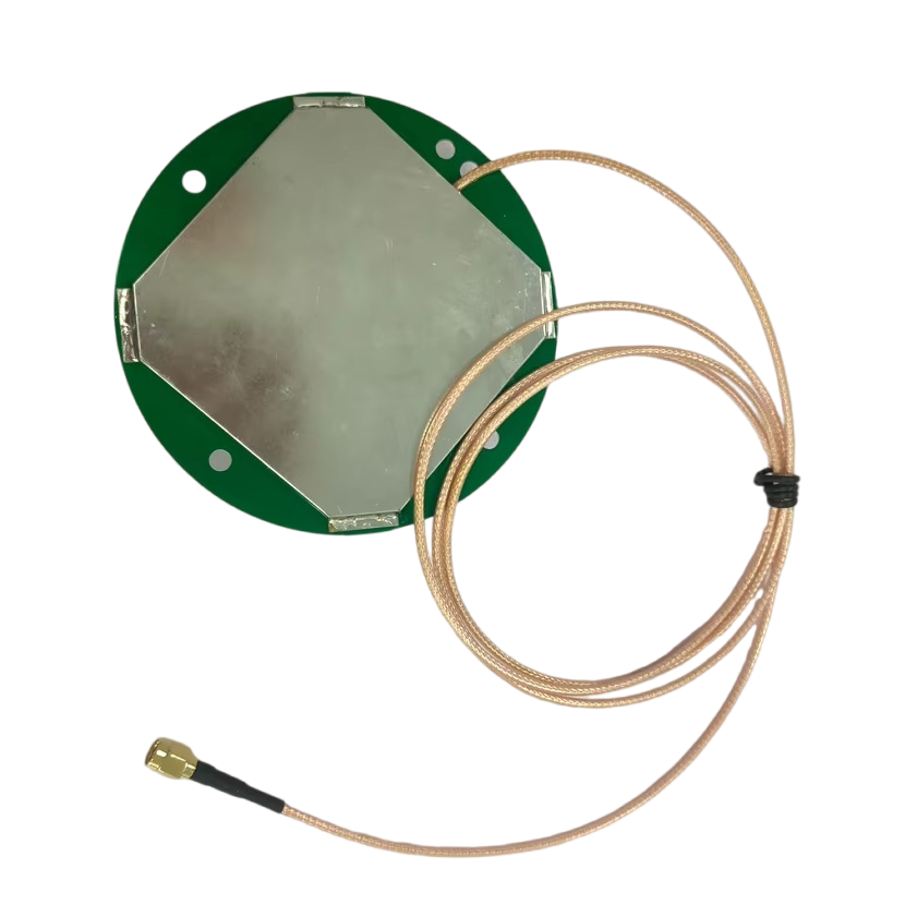
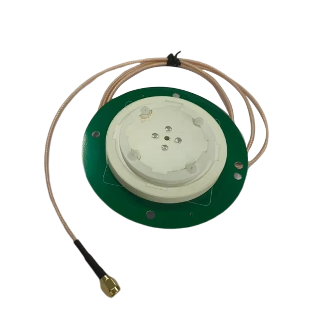
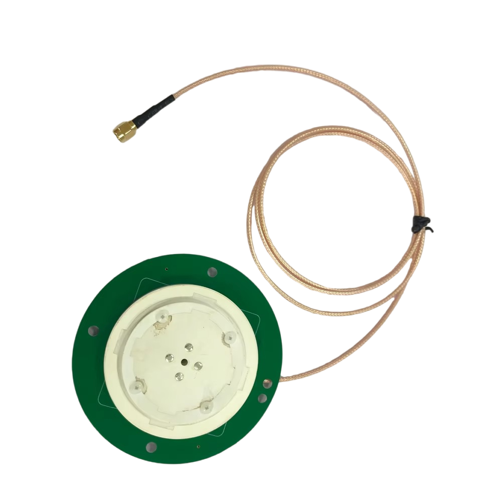
The design and construction of a Compact RTK Combination Antenna are a meticulous exercise in electromagnetic engineering, materials science, and mechanical robustness. Every aspect of its architecture is optimized to maximize signal reception, minimize interference, and ensure durability in harsh environments. The design can be broken down into several key subsystems.
1. The GNSS Antenna Element:
The heart of the device is the GNSS antenna, typically a Quadrifilar Helix Antenna (QHA) or more commonly, a precision-designed patch antenna. Patch antennas are favored for their low profile, hemispherical coverage, and excellent phase center characteristics.
Substrate and Patch: The radiating element is a metallic patch (often copper) etched onto a dielectric substrate. The material and thickness of this substrate are critical as they affect the antenna's bandwidth and efficiency. Low-loss, temperature-stable materials like ceramic or PTFE (Teflon) are used to maintain performance across varying environmental conditions.
Ground Plane: Beneath the patch lies a continuous ground plane, which is essential for defining the antenna's radiation pattern. A well-designed ground plane ensures the antenna has a wide, hemispherical view of the sky to track satellites from horizon to horizon, while rejecting multipath signals reflected from the ground.
Phase Center: The most critical property of a survey-grade GNSS antenna is its stable phase center. This is the electrical point from which the signal is received, and it must remain consistent regardless of the satellite's azimuth or elevation angle. Any variation introduces error into the precise carrier-phase measurements. Designers use intricate feeding techniques and stacked patches to create a constant and well-defined phase center.
Radome: The antenna is protected by a radome. This cover must be radio-transparent at GNSS frequencies. Materials like polycarbonate or ABS plastic are common. Its shape is also engineered—a dome shape helps to minimize the accumulation of water, snow, or dirt, which can detune the antenna and degrade performance.
2. The Data Link Antenna:
Integrated within the same radome, or more often as a separate element encircling the base of the GNSS antenna, is the data link antenna. This is typically a cellular antenna (for NTRIP correction networks) or a UHF radio antenna (for direct radio links).
Integration Challenge: The major design hurdle is isolating the powerful transmit signal of the data link (which can be +23 dBm or more) from the ultra-sensitive GNSS receiver, which is trying to detect signals as weak as -130 dBm. Without proper isolation, the data link transmission can completely desensitize the GNSS receiver, causing it to lose lock on satellites.
Isolation Techniques: Engineers achieve this through a combination of:
Spatial Separation: Physically placing the two antennas as far apart as possible within the housing.
Frequency Separation: Using inherent frequency band filters (GNSS at ~1.5 GHz, Cellular at ~1.8-2.1 GHz, UHF at 400-900 MHz).
Shielding: Incorporating metallic shields and absorptive materials between the antennas.
Filtering: Implementing advanced band-pass and notch filters in the electronic circuitry to block out-of-band interference.
3. Low-Noise Amplifier (LNA):
Immediately behind the GNSS patch antenna is a Low-Noise Amplifier. Its purpose is to boost the incredibly weak satellite signals before they travel through the cable to the receiver, thereby overcoming the signal loss inherent in the coaxial cable. A high-gain, low-noise-figure LNA is crucial for achieving good system sensitivity.
4. Housing and Mechanical Design:
The housing is more than just a shell; it is a critical part of the antenna system.
Materials: Typically made from robust, UV-resistant plastics or metal alloys. The base often contains a strong magnet for quick attachment to metal surfaces (e.g., vehicle roofs) and a standard threaded mount (e.g., 5/8"-11) for permanent installation on poles or masts.
Environmental Sealing: To meet IP67 or higher ratings, the unit is fully sealed with O-rings and gaskets to be waterproof and dustproof, ensuring reliable operation in rain, snow, and dusty conditions.
Cable and Connector: A single, ruggedized coaxial cable with a weatherproof connector (e.g., TNC, SMA) carries both the amplified GNSS signal and, in many modern designs, DC power to the integrated LNA. Some advanced models also integrate the RTK receiver and modem directly into the antenna body, making it a truly "all-in-one" solution that outputs position data directly via a single Ethernet or USB cable.
In essence, the construction of a Compact RTK Combination Antenna is a complex balancing act, harmonizing the conflicting demands of multiple RF systems within a minimal volume while ensuring the whole assembly is mechanically robust and environmentally sealed for field deployment.
The working principle of a Compact RTK Combination Antenna is best understood by following the data flow from satellite signals to a finalized centimeter-accurate position. It operates as the critical front-end for an RTK system, which relies on the carrier phase of the GNSS signal rather than the encoded information.
Step 1: GNSS Signal Reception and Amplification
The process begins with the GNSS antenna element capturing faint electromagnetic waves transmitted from satellites in Medium Earth Orbit. These signals, centered around 1.5 GHz (L1, L2, L5 bands), contain a spread-spectrum code (C/A code, P-code) and a carrier wave. The antenna's design ensures it receives signals from a wide field of view with a stable phase center. The weak signals, often just billionths of a watt, are immediately amplified by the integrated Low-Noise Amplifier (LNA). This initial amplification is vital to prevent the signals from being drowned out by the inherent thermal noise introduced by the coaxial cable that connects the antenna to the RTK receiver.
Step 2: Data Link Operation - The Correction Pathway
Simultaneously, the antenna is engaged in two-way communication via its data link. The RTK process requires a reference, typically a stationary base station at a known location. There are two primary modes:
RX Mode (Receiving Corrections): The built-in cellular modem receives correction data from an NTRIP (Networked Transport of RTCM via Internet Protocol) caster. This data, formatted in RTCM (Radio Technical Commission for Maritime Services) messages, contains the observed carrier phase errors from the base station.
TX/RX Mode (For Rover-Base Setup): In a traditional setup, the combination antenna may be on a rover unit. It transmits its own raw GNSS observation data to the base station (via radio or cellular) and, in turn, receives the correction data calculated by the base.
Step 3: Signal Processing in the RTK Engine
The amplified GNSS signals from the antenna and the correction data from the modem are fed into the RTK receiver (which may be external or integrated). The receiver's processor performs several complex tasks:
Carrier Phase Tracking: It locks onto the carrier phase of the signals from each satellite. The wavelength of the GPS L1 carrier, for example, is only about 19 cm. By measuring the phase of this wave, incredibly precise range measurements can be made.
Double Differencing: This is the mathematical core of RTK. The receiver calculates the difference between the phase measurement made by the rover and the phase measurement made by the base station for the same satellite. It then differences that result between two different satellites. This "double difference" cancels out nearly all common errors: satellite clock errors, receiver clock errors, and the vast majority of atmospheric (ionospheric and tropospheric) delays.
Ambiguity Resolution: The initial carrier phase measurement is ambiguous—the receiver knows the fractional part of the wavelength but not the integer number of full wavelengths between the satellite and antenna. Resolving this integer ambiguity is the key to centimeter accuracy. The receiver uses the code-phase measurements and the correction data to statistically search for and fix the correct integer values. Once this "integer fix" is achieved, the position is known with centimeter-level precision.
Step 4: Position Output
With the ambiguities resolved, the RTK engine can now compute the precise vector (baseline) between the base station and the rover antenna. Since the base station's coordinates are known to within millimeters, the rover's position can be calculated with equal precision. This precise latitude, longitude, and height are then output at a high rate (5-20 Hz) via serial, USB, or Ethernet protocols to the host system—be it an autopilot on a tractor, the flight controller of a drone, or a mapping software on a tablet.
The entire working principle hinges on the antenna's ability to provide a clean, stable, and low-noise GNSS signal and a reliable, low-latency communication channel for the corrections. Any degradation in signal quality—from interference, multipath, or a dropped correction link—directly impacts the system's ability to achieve and maintain a fixed RTK solution, reverting it to a less accurate, meter-level positioning mode.
The adoption of Compact RTK Combination Antennas brings a host of significant advantages that revolutionize precision positioning, but it also introduces unique engineering and operational challenges that must be carefully managed.
Advantages:
System Integration and Simplicity: The most profound advantage is the radical simplification of the system architecture. By combining two critical antennas and often integrating the LNA and filters, it reduces the number of separate components, cables, and connections. This leads to easier installation, lower overall system cost, and greatly improved reliability by eliminating common points of failure like cable connectors and separate antenna mounts.
Enhanced Reliability and Robustness: A single, professionally sealed unit is far more robust than a makeshift setup with multiple cables and antennas. It is designed from the ground up to be waterproof, dustproof, and resistant to vibration and shock, making it ideal for demanding environments like agriculture, construction, and marine applications.
Optimized Performance: Because the GNSS and data link antennas are co-designed by engineers, they can be optimized to work together. Careful placement and shielding minimize inter-system interference, leading to better performance than what might be achieved by haphazardly placing two separate antennas in close proximity on a platform.
Portability and Mobility: The compact form factor is essential for applications where size, weight, and power (SWaP) are constrained. It enables high-precision positioning on drones, handheld mapping devices, robotic platforms, and wearable gear, opening up new use cases that were previously impossible.
Reduced Multipath: The integrated ground plane and carefully designed radome help to reject signals reflected from the ground (multipath), which are a major source of error in precision GNSS. A well-designed combination antenna can have superior multipath rejection compared to a simple patch antenna without a proper ground plane.
Challenges:
Electromagnetic Interference (EMI): This remains the paramount engineering challenge. Despite best efforts, the close proximity of a high-power transmitter (cellular/UHF) to an ultra-sensitive receiver creates a difficult interference scenario. Designing filters and shields that are effective without being overly large, heavy, or expensive requires sophisticated engineering and can drive up the cost of the unit.
Power Consumption: Integrating an active cellular or radio modem within the antenna housing increases power consumption. For battery-operated platforms like drones, this can be a significant consideration, reducing flight times. Efficient power management is crucial.
Thermal Management: The LNA, modem, and other active components generate heat. In a sealed, compact enclosure with limited airflow, managing this heat buildup is critical to prevent performance degradation or component failure over time, especially when operating in direct sunlight.
Cost: High-performance GNSS components (stable patch antennas, high-quality LNAs) and robust cellular modems are inherently expensive. Combining them into a single, ruggedized package with specialized RF engineering results in a component that is significantly more costly than a basic GNSS antenna. This can be a barrier to entry for some cost-sensitive applications.
Dependency on Correction Link: The antenna's ultimate performance is entirely dependent on the availability and latency of the correction data link. In remote areas with poor cellular coverage, a cellular-based unit will be unusable. Similarly, UHF radio links have limited range and can be obstructed by terrain. The system is only as strong as its weakest link.
In conclusion, while the advantages of integration, simplicity, and performance are transformative, successfully deploying these antennas requires an understanding of their limitations, particularly regarding EMI, power, and connectivity, to ensure they are matched to the application's specific requirements.
The Compact RTK Combination Antenna is a key enabling technology, finding applications wherever precise, reliable, and mobile positioning is required. Its influence is rapidly expanding across a diverse range of industries, and its future evolution is tied to the advancement of autonomy and connectivity.
Applications:
Precision Agriculture: This is one of the largest markets. RTK-guided tractors and harvesters automate field operations with centimeter accuracy, enabling straight rows, avoiding overlaps (saving seed, fertilizer, and fuel), and enabling yield mapping. Autonomous spraying robots also rely on this technology for precise navigation.
Unmanned Aerial Vehicles (UAVs / Drones): Drones for surveying, mapping, mining volume calculations, and corridor mapping require precise geotagging of every captured image. A compact RTK antenna provides the necessary positioning accuracy for photogrammetry without the need for numerous ground control points, drastically reducing survey time.
Robotics and Autonomous Vehicles: From last-mile delivery robots navigating city sidewalks to warehouse robots managing inventory and large-scale autonomous mobility, these systems require an absolute position fix to correlate sensor data (LiDAR, cameras) with a high-definition map. The RTK antenna provides this foundational layer of localization.
Surveying and Construction: While traditional surveyors use larger equipment, combination antennas are used for machine control (guiding bulldozers and graders to exact grade), for as-built verification, and on handheld devices for GIS data collection, providing high accuracy in a portable form factor.
Marine and Hydrography: Used on autonomous surface vessels (ASVs) for bathymetric surveys, on buoys for precise monitoring, and for port automation, where knowing the exact position of cranes and containers is critical.
Emerging Consumer and Industrial Applications: This includes augmented reality (AR) systems that need to precisely anchor digital content to the physical world, and personal mobility devices for the visually impaired.
Future Trends:
Tighter Integration: "Antenna as a Sensor": The trend is toward further integration. The next generation will see the RTK receiver, IMU (Inertial Measurement Unit), and modem fully embedded within the antenna housing. This creates a complete "positioning engine" or "sensor" that outputs finalized, robust position, velocity, and time (PVT) solutions via a single Ethernet cable, abstracting away the underlying GNSS complexity for the end-user.
Multi-Band, Multi-Constellation Becomes Standard: Future antennas will be designed from the outset to receive all modern signals (GPS L5, Galileo E5, BeiDou B2a). This provides more signals, faster integer ambiguity resolution, and better resilience in challenging signal environments like urban canyons.
Advanced Interference Mitigation: With the RF spectrum becoming increasingly crowded, future designs will incorporate more sophisticated on-board interference detection and mitigation techniques, such as adaptive filtering and null-steering capabilities, to maintain operation in hostile RF environments.
AI and Cloud Integration: Antennas and receivers will become smarter, using machine learning models to predict signal outages, optimize tracking loops, and even select the best correction stream from a network automatically. Cloud-based correction services (PPP-RTK) will become more prevalent, offering global centimeter-level accuracy without the need for a local base station.
Miniaturization and Reduced Power: As components become smaller and more efficient, the antennas will shrink further and consume less power, enabling their integration into smaller devices like smartphones, wearables, and micro-mobility scooters, bringing centimeter-accuracy to the mass market.
The Compact RTK Combination Antenna will continue to evolve from a specialized component into a ubiquitous sensor, forming the cornerstone of the positioning infrastructure for the autonomous future.
Conclusion
The Compact RTK Combination Antenna is far more than a simple peripheral; it is a transformative technology that has democratized access to centimeter-accurate positioning. By solving the critical integration challenge of co-locating a high-precision GNSS antenna with a robust data link, it has dismantled the barriers of complexity, cost, and reliability that once limited high-accuracy GNSS to specialized survey applications. This innovation has been a fundamental catalyst for the rapid advancement of autonomy across agriculture, construction, drone technology, and robotics.
Its value proposition lies in its elegant synthesis of multiple complex systems into a single, rugged, and user-friendly package. This synthesis enhances performance through careful electromagnetic design, boosts reliability by eliminating failure-prone external connections, and enables entirely new applications through its compact and mobile form factor. However, this integration is not without its challenges, primarily the perpetual battle against electromagnetic interference and the dependency on continuous correction data links, which necessitate careful system design and deployment planning.
Looking forward, the trajectory of this technology is one of continued convergence and intelligence. The antenna is evolving into a complete, self-contained positioning sensor, absorbing more functionality like inertial navigation and advanced processing. As it becomes smaller, more powerful, and more connected to cloud services, its role will expand from guiding large machines to enabling precise location context for a vast Internet of Things (IoT) and augmented reality experiences. The Compact RTK Combination Antenna has successfully bridged the gap between the satellite-powered world of absolute positioning and the connected world of real-time data, and in doing so, it has firmly established itself as an indispensable component in building the intelligent, automated systems of the future.

 86 0755 2819 9597
Lucy Yang | lucy.y@toxutech.com
Nicole Li | nicole@toxutech.com
Dotty Zhao | sales04@toxutech.com
Global Business Director / Sales Team / Global Operations


 En
En Cn
Cn Korean
 Home >


